
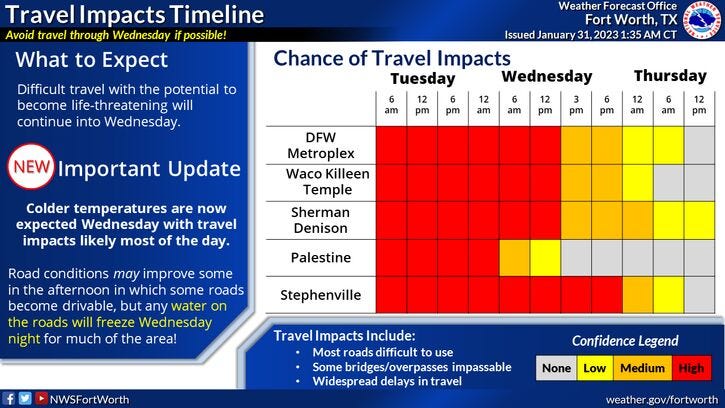
The National Weather Service on Tuesday issued an Ice Storm Warning for more than a dozen North Texas counties. The warning goes into effect Wednesday at 6 a.m. for Comanche, Denton, Eastland, Erath, Hood, Jack, Johnson, Palo Pinto, Parker, Somervell, Stephens, Tarrant, Wise, and Young counties.
A Winter Storm Warning remains in effect for counties not impacted by the Ice Storm Warning. Both warnings expire at 6 a.m. on Thursday.
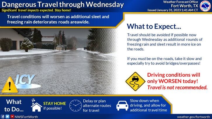
Widespread sleet broke out to the south on Tuesday morning and moved across the area through the early afternoon. All of it stuck and will stay around all day long because temperatures will hover in the mid to upper 20s. The widespread sleet tapered off around 12 p.m.
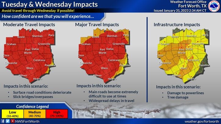
Tuesday night, areas of light freezing drizzle will break out, changing over to all freezing rain by Wednesday morning and expanding in coverage and intensity throughout the day. Some areas will pick up a half inch of freezing rain, wreaking havoc across the area. This is when sporadic power outages may take place as the day wears on as tree branches could fall into power lines. Make sure you have supplies to keep warm and to be able to see Wednesday night.
We will wake up to more freezing rain across much of the area on Thursday morning, however, the freeze line will creep from southeast to northwest through the day. Most areas will be above freezing by afternoon, causing the freezing rain to change over to cold rain, This will all end by early evening. Afternoon highs will be in the low to mid-30s.
Sunshine returns Friday lasting into Monday. Highs Friday near 50, low 60s Saturday, mid-60s Sunday, and the upper 60s by Monday.
*Yest Rain: 0.01"; High: 30; Low: 37
*Today’s Averages: High: 58; Low: 37
*Record high: 93 (1911); Record low: -2 (1949)
*2023 rain: 1.02"; Deficit: 1.36"
*Sunrise: 7:25am; Sunset: 5:59pm
Today: Cloudy, breezy and cold. Waves of Sleet through noon, isolated after that. High: Mid to upper 20s. Wind: North 10-20 mph.
Tonight: Cloudy, breezy and cold. Areas of freezing drizzle. Low: Mid to upper 20s. Wind: North 10 mph.
Tomorrow: Cloudy, breezy and cold. Widespread freezing rain. High: 28-31. Wind: NNE 5-10 mph.
Thursday: Cloudy and cold. Last wave of morning freezing rain, changing to all cold rain east of 35W. Ending by late afternoon. High: Low to mid 30s.
Friday: Sunny and cool. Thawing out. High: Low 50s.
Saturday: Sunny and a bit warmer. High: Low 60s.
Sunday: Mostly sunny and pleasant. High: Mid 60s.
Monday Mostly sunny and nice. High: Upper 60s.
Related

LISTEN on the Audacy App
Sign Up and Follow NewsRadio 1080 KRLD