

Buffalo, N.Y. (WBEN) - A sigh of relief can be felt across the Buffalo southtowns as lake effect snow that has pounded the area has finally made a move for the north, giving Buffalo and the northtowns a turn at the relentless snow machine dumping accumulations by the foot off the eastern end of Lake Erie.
"The intense band of snow across Buffalo metro will continue to produce snowfall rates of 3"/hr this morning as it moves northward into Northern Erie and Niagara counties," the National Weather Service says in its morning forecast discussion. "Expect an additional 6 to 12 inches from this band north of a downtown Buffalo to Clarence line," forecasters say.
The lake effect snow band is forecast to begin to drop southward across the Buffalo metro area and settle into the southern portion of the region beginning at around 8 pm Saturday. After another accumulation of 8 to 12 inches, the band will weaken and remain well south.
After days of meteorologists warning that an intense lake effect snow event was setting up to target metro Buffalo with the potential for 4 feet of snow, any naysayers are being quieted as the snow totals actually rival the 4 foot benchmark and continue to grow.
Orchard Park was perhaps the hardest hit community, with as much 54 inches of snow reported in parts of the town. East Aurora, Hamburg and West Seneca were also hard hit as the intense line of snow that set up from the Chautauqua ridge inland, across the southtowns and northward just south of a line from South Buffalo to the airport.
Municipal crews have been working across the southtowns to keep main highways passable for emergency crews for the past 36 hours and are now finally able to go deeper into their communities, moving mountains of snow with plows and heavy equipment.
Check: WBEN Closings
The heavy snow forced the closure of the NYS Thruway from I-190 to Dunkirk, Routes 219 and 400 and the Route 5 lakeshore complex Friday. Driving bans remain in place for areas south of William Street in Buffalo.
The lake effect snow forecast forced the Buffalo Bills and the NFL to make the decision late Thursday to move Sunday's Bills game to Detroit.
Related

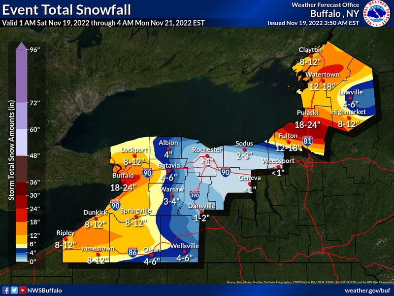
Here is the latest snowfall total forecast from the National Weather Service for Saturday through Monday.
You can read the warning and watches posted by the National Weather Service below and stay tuned to News Radio 930 WBEN for the latest as the forecast continues to evolve.

LAKE EFFECT SNOW WARNING REMAINS IN EFFECT UNTIL 1 PM EST SUNDAY
* WHAT...Heavy lake effect snow. Additional snow accumulations of 8 to 16 inches in the most persistent lake snows. Winds gusting as high as 40 mph.
* WHERE...Northern Erie and Genesee counties. Lake effect snow across the Buffalo metro area early this morning will move north of the area this afternoon before moving back south across the area tonight into Sunday morning.
* WHEN...Until 1 PM EST Sunday.
* IMPACTS...Travel could be very difficult to impossible. Areas of blowing snow could significantly reduce visibility.
PRECAUTIONARY/PREPAREDNESS ACTIONS...
Heavy snow will fall in relatively narrow bands. If traveling, be prepared for rapidly changing road conditions and visibilities.
LAKE EFFECT SNOW WARNING IN EFFECT FROM 10 PM THIS EVENING TO 1 PM EST SUNDAY
* WHAT...Heavy lake effect snow expected. Total snow accumulations of 5 to 10 inches in the most persistent lake snows. Winds gusting as high as 40 mph.
* WHERE...Southern Erie county.
* WHEN...From 10 PM this evening to 1 PM EST Sunday.
* IMPACTS...Travel could be very difficult. Areas of blowing snow could significantly reduce visibility.
PRECAUTIONARY/PREPAREDNESS ACTIONS...
Heavy snow will fall in relatively narrow bands. If traveling, be prepared for rapidly changing road conditions and visibilities.
LAKE EFFECT SNOW WARNING REMAINS IN EFFECT UNTIL 7 AM EST SUNDAY
* WHAT...Heavy lake effect snow. Additional snow accumulations of 6 to 12 inches in the most persistent lake snows. Winds gusting as high as 40 mph.
* WHERE...Niagara county.
* WHEN...Until 7 AM EST Sunday.
* IMPACTS...Travel could be very difficult to impossible. Areas of blowing snow could significantly reduce visibility.
PRECAUTIONARY/PREPAREDNESS ACTIONS...
Heavy snow will fall in relatively narrow bands. If traveling, be prepared for rapidly changing road conditions and visibilities.
LAKE EFFECT SNOW WARNING IN EFFECT FROM 10 PM THIS EVENING TO 10 PM EST SUNDAY
* WHAT...Heavy lake effect snow expected. Total snow accumulations of 6 to 12 inches in the most persistent lake snows. Winds gusting as high as 35 mph.
* WHERE...Cattaraugus county.
* WHEN...From 10 PM this evening to 10 PM EST Sunday.
* IMPACTS...Travel could be very difficult to impossible. Areas of blowing snow could significantly reduce visibility.
PRECAUTIONARY/PREPAREDNESS ACTIONS...
Heavy snow will fall in relatively narrow bands. If traveling, be prepared for rapidly changing road conditions and visibilities.
LAKE EFFECT SNOW WARNING IN EFFECT FROM 10 PM THIS EVENING TO 10 PM EST SUNDAY
* WHAT...Heavy lake effect snow expected. Total snow accumulations of 6 to 12 inches in the most persistent lake snows. Winds gusting as high as 40 mph.
* WHERE...Chautauqua county.
* WHEN...From 10 PM this evening to 10 PM EST Sunday.
* IMPACTS...Travel could be very difficult to impossible. Areas of blowing snow could significantly reduce visibility. Gusty winds could bring down tree branches.
PRECAUTIONARY/PREPAREDNESS ACTIONS...
Heavy snow will fall in relatively narrow bands. If traveling, be prepared for rapidly changing road conditions and visibilities.Localized travel problems will be possible.
WINTER WEATHER ADVISORY REMAINS IN EFFECT UNTIL 7 AM EST SUNDAY
* WHAT...Snow. Additional snow accumulations of 3 to 5 inches.
Winds gusting as high as 40 mph.
* WHERE...Orleans county.
* WHEN...Until 7 AM EST Sunday. Most of the snow will fall this morning, and then again tonight with a break during this afternoon.
* IMPACTS...Plan on slippery road conditions.
PRECAUTIONARY/PREPAREDNESS ACTIONS...
Periods of snow will result in snow covered roads and limited visibilities. Slow down and use caution while driving.
WINTER WEATHER ADVISORY IN EFFECT FROM 10 PM THIS EVENING TO 1 PM EST SUNDAY...
* WHAT...Lake effect snow expected. Total snow accumulations of 4 to 7 inches in the most persistent lake snows. Winds gusting as high as 40 mph.
* WHERE...Wyoming county. Mainly across western portions of the county.
* WHEN...From 10 PM this evening to 1 PM EST Sunday.
* IMPACTS...Plan on slippery road conditions. Areas of blowing snow could significantly reduce visibility.
PRECAUTIONARY/PREPAREDNESS ACTIONS...
Lake effect snow will fall in relatively narrow bands. If traveling, be prepared for rapidly changing road conditions and visibilities.