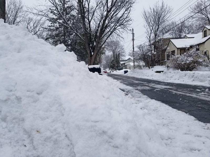

The Sunday night, Monday morning light snow event turned into more than we bargained for.
WCCO Chief Meteorologist Paul Douglas says predictions of an inch or two were exceeded across a large portion of southern and central Minnesota as you headed out the door Monday.
“It is pretty out there, coating everything, but it's more than we thought,” Douglas says. “This winter is exhibit A, it pays to be conservative when you're predicting snowfall amounts. If the models say eight go four. You'll be closer to the truth. But yesterday we were thinking two to four and it's really more like three to six.”
There were areas to the south of the metro that actually got more. There were almost seven inches near Chanhassen, and almost eight inches in Oakdale where the heaviest snow set up.
“There was a band of very heavy snow that set up yesterday evening and last night from New Ulm, right up the Minnesota Valley into the south metro,” Douglas told Vineeta Sawkar on the WCCO Morning News. “It was snowing at the rate of an inch an hour. There was some thunder and lightning. It was convective snow, which actually is a sign of spring.”
For the rest of Monday, there could be some more light snow, mostly cosmetic says Douglas. Roads should remain mainly wet and temps do rise above freezing.
More Snow on the Way
We get a break Tuesday. A one day break. Welcome to the winter of 2022-23. That break comes before the next major system drifts into Minnesota late Wednesday, Wednesday night and then all the way into Friday.
“Thursday and Friday look like snowy days,” says Douglas. “Still a little early to be giving amounts and all of that. What I will say is that the computer models are all over the map. I'd say the consensus right now, if there is one, is six to ten inches, maybe a foot worst case. Or best case scenario.”
That makes it sound likely that we will see plow-able amounts of snow Thursday and Friday. By the weekend it should wind down.
Douglas will have more updates as the storm settles into a track Tuesday, and especially Wednesday, but get ready for more of the white stuff.
Already One of Minnesota’s Snowiest Winters
Douglas says there’s no question now we’ll see a top ten winter snowfall, maybe by the end of the week.
To get into the top 10 we have to hit 78.4,” Douglas explains. “With the snow that fell last night we're right around 74 officially at MSP International where the official measurements are taken. So 78.4 top ten and if we get to 85 that would be a top five winter. I'm starting to think we stand a really good chance of getting to 85 before the daffodils finally pop up.”
The Twin Cities have only had seven winters exceed 80 inches of snow so we’re getting pretty historic now.
Boy’s Hockey Tournament…. And a snow storm
It’s almost a tradition in Minnesota. The Boy’s State Hockey Tournament is at the Xcel Energy Center later this week, and now we have a storm looming.
It begins Wednesday, and for those teams that are traveling from Greater Minnesota they may have to navigate some tough travel weather. Douglas says it should be doable though.
“It (snow) actually starts late Wednesday, Wednesday night,” Douglas said. “I think if you're traveling much of the day Wednesday will be okay. The bad travel days will be Thursday and Friday morning and midday. Hard to say when this will taper off. It may get better late in the day Friday if you want to be safe. I think getting home on Saturday we should be dug out.”
Douglas adds that even when it is snowing, we're going to be consistent mid to upper thirties which gives MnDOT a much better chance to keep the roads cleared.
“I don't think it's going to be crippling, but it could be very plow-able and we'll keep you posted and hope the models kind of agree here in the coming days,” Douglas said. “But I think it's going to be enough to shovel and plow, meaning at least six inches by the end of the week.
Related

Spring Flooding Potential
Douglas says that once again, the Red River could be under the gun for flooding, but so is the Minnesota and even the Mississippi RIvers.
“The odds of significant river flooding are higher than usual because we have so much water,” Douglas says. “After last night, after this week's snow, we're going to have three, four, five inches of liquid water or more tapped into that snow pack.
He explains that the tough part in predicting flooding each spring is knowing know how much is it going to rain over the next four to six weeks.
“And will that rain be accompanied by fifties, which could happen,” he says. “We just don't know if it's a gradual, slow motion meltdown, thirties and then we ease into the forties and a few light rain events. That would be a best case scenario. If we get a warm front, fifties and heavy rain on top of the snow, that would mean rapid runoff and that would greatly increase the chance of significant flooding.”
But certainly, we're locked and loaded for a more concerning spring flooding scenarios than usual.
The good news is we have eased our drought conditions.
“You know, we've been in a drought for the better part of two, two and a half years,” Douglas said. “We really didn't have to worry about this, but the soil moisture is back. We're out of the drought now, at least central and eastern Minnesota. If you live in an area that has had spring flooding in the past, you should certainly be alert, take precautions and stay tuned.”
Forecast
Monday: Some light flurries. High 36.
Tuesday: Mostly cloudy. High 37, low 28.
Wednesday: Light snow arrives late in the day, overnight. High 34, low 28.
Thursday: Heavy snow potential. High 33, low 29.
Related
