

It’s been a glorious week of Minnesota weather, with temps mostly in the 70s across the state. Friday is just as nice. WCCO Chief Meteorologist Paul Douglas takes you through a couple of weather headlines as we hit the weekend.
Why yes, it has been very windy.
Have you noticed how windy is has been? If you’re thinking this summer has been particularly breezy, you’re not wrong.
Douglas says the wind has actually been historic across the state.
“Dr. Kenny Blumenfeld of the Minnesota DNR and the State Climate Office, he's the guy that that brought this to my attention because I've been hearing from a lot of people, and I've noticed it myself,” Douglas told Adam Carter on the WCCO Morning News Friday.
It's hard not to notice the fact that the wind, which we've always had, just seemed to be at a entirely new level this year.
“And sure enough, at least going back 40 years, it has been the windiest year in the Twin Cities and most of Minnesota, on record,” Douglas said. “He (Blumenfeld) believes that the data may actually go back farther than 40 years. He said, ‘look, there are a couple of caveats. The wind instrumentation is more sensitive now.’ And that technology has improved. Some of that could be the wind sensors. They've moved the location of where they measure the official winds around the Twin Cities. That could be a factor. So a couple of caveats and disclaimers.”
All of that to say, there is still a fair amount of evidence that we are living through the windiest year since at least 1980, and a lot longer according to Douglas and the evidence from the State Climatological Office.
This beautiful Friday weather is about to heat up.
Douglas also says it’s going to be a hot wind again heading into this weekend, and again mid-week.
“It’s going to be back up near 90 on Saturday and Sunday, and then a little bit of a break on Monday,” says Douglas. Only mid-eighties before the next wave of heat. By the middle of next week, I think mid-nineties. The European model, which as you know is my favorite, is saying 100 the first Saturday of August. So not this Saturday, but the following Saturday in the metro. That that may be a little high, but there's little doubt we're going to be well up into the 90s again.”
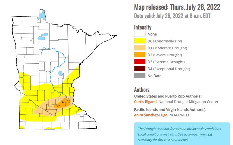
Central Minnesota continues to battle drought conditions.
The Twin Cities metro, especially the southern ‘burbs, is really dry.
“The drought, which is now severe over the south metro, I can't see how we avoid the drought getting worse as we push into August,” Douglas predicts. “I wish I had some better news on that score. But my sense, my Spidey sense, is that we're going to be using the D word, the drought word, well into August. Possibly longer and we're getting a taste of that heat next week. There's little doubt last year was the warmest year on record in the Twin Cities and at the rate we're going this summer maybe close in terms of the extent of the heat. So I wish I had better news.
The MSP metro is nearly 6" drier than average since June 1. And that is nothing compared to the western U.S. where it's not only in drought, it's in exceptional drought which is the worst categorization the U.S. Drought Monitor uses. The west is literally drying up.
Is there any rain in our future?
A few storms late Sunday, Sunday night,” Paul says. “Enough to settle the dust. Some of those storms could even be severe. We'll have to keep an eye on that.”
However, he says the current weather pattern does not favor significant rain anywhere in the state looking out the next two weeks.
“Hopefully that pattern will shift as we get into late August, September,” says Douglas. “But in the near term I think hot, dry and windy.”
An early look at State Fair Weather.
Is this going to be a hot, sweaty State Fair? Will it stay dry? Paul says it’s a bit far out to know for sure, but the trend is in that direction.
“When in a drought, don't predict rain. When in debilitating heat, don't predict cool fronts,” he says. “So yeah, that's way over the horizon, but if I had to gamble I'd gamble on a hot, sweaty State Fair again this year. Yeah, absolutely.”
Related

Related
