

LEXINGTON (WWJ) - The National Weather Service confirmed a tornado did cause damage in Sanilac County during yet another bout of severe weather on Friday afternoon.
The NWS sent a team to survey damage from the reported twister that touched down between 3:30 p.m. and 3:35 p.m. on July 14 in the city of Lexington Township, Applegate and others parts of east and central Sanilac County.
According to the report released just before 4 p.m. on Saturday, the tornado reached maximum wind gusts of 85 mph and tracked for roughly 5 miles.
"Tornado touched down southeast of Applegate and tracked southeast through Townsend Road and Wixson Road," officials said. "The main damage in this area was large snapped tree limbs and crop damaged. Estimated winds in this area were up to 70 mph."
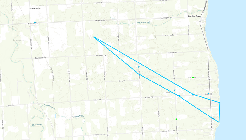


Heavier, more concentrated damage began near the intersection of Babcock Road and Aitken Road where surveyors reported several large limbs had been snapped and softwood trees uprooted in a "circular pattern" with one home having minor damage to its fascia.
"Estimated peak winds in this concentrated area of damage were up to 80 mph with a width of 475 yards," the NWS added. "The track continued moving to southeast crossing M-25 into Sanilac County Lexington Park where additional large tree limbs were downed and one snapped small softwoodtree. One of the larger tree limbs fell onto a camper in the park."
Experts said the tornado's path eventually exited into Lake Huron.
According to weather experts, radar indicated a strong, low-level rotation during a storm across the central portion of the county in Michigan's Thumb region.
The severe weather threat prompted a Tornado Warning for roughly 13,000 residents in the area at 3:16 p.m. The alert expired about 30 minutes later.
According to officials, reports of downed trees, debris in the road and damage to buildings strongly suggested a tornado touched down.
According to DTE Energy's Outage Map, a couple hundred residents in Sanilac County were without power on Saturday morning. The company sited wind damage in some of the outages reported around in the southern portions of Lexington while others in the area have yet to be determined by crews.
Throughout all of Metro Detroit, a little over 2,300 DTE customers are in the dark after another round of strong weather hit Southeast Michigan. After a month of nearly no precipitation back in May and June of this year, this week has more than made up for it as torrential downpours, strong wind gusts, damaging hail and more threatened most of the southern portions of the Lower Peninsula from New Haven to Detroit.
Friday's severe weather event in Lexington is the second tornado to hit Michigan within 48 hours with a confirmed touchdown Wednesday night near Colon in St. Joseph County, not far from Kalamazoo.
Related
