
(WWJ) - Summer may be waning, but Mother Nature isn't done packing a punch as the Mitten State is set to see severe storms and heat indices soar up to 100 degrees on Wednesday.
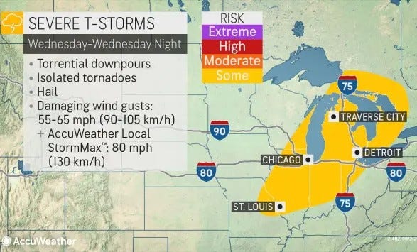
AccuWeather meteorologists say a fresh line of thunderstorms with hail, damaging wind gusts and flooding downpours will sweep through much of the Lower Peninsula.
A line of strong storms is expected to barrel through the northern parts of Minnesota, Wisconsin and the U.P. on Tuesday. While some of those storms may affect portions of lower Michigan into Tuesday night, a new system is expected to fire up Wednesday and impact the listening area.
"The severe risk on Wednesday will shift to the south and east, covering areas of Missouri, Iowa, Wisconsin, Illinois, Indiana, Michigan, Ohio and Ontario," said AccuWeather Meteorologist Andrew Kienzle.
Detroit, Grand Rapids and Traverse City will be caught in the crosshairs -- the National Weather Service estimates more than 32 million across the Midwest could be at risk of some form of severe weather.
"Damaging wind gusts will be the primary severe threat across the entire region, but potential for supercells and stronger low-level hodograph curvature suggests a tornado or two is possible across northern Lower MI," the NWS forecasted.
The NWS said hot, humid air will will fuel the severe weather. Temperatures are expected to rise into the lower 90s with heat indices peaking around 100 degrees.
The heat may even reach the high of 96 degrees, AccuWeather said.
So far, no advisories or alerts have been issued for Metro Detroit, but meteorologists recommend residents stay alert as advisories and watches can change at a moment's notice.
You can stay tuned to your traffic and weather together every ten minutes on the :08s LIVE on WWJ.
Related
