
DETROIT (WWJ) -- If you've got some holiday shopping left to do, you should plan to have it done by Wednesday night.
The National Weather Service is warning of a "rapidly intensifying winter storm" that will bring accumulating snowfall, strong wind gusts, and bitter cold to Southeast Michigan just ahead of the Christmas weekend.
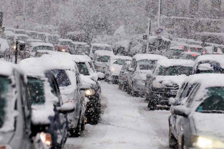
Along with the snow, the NWS says the primary concerns with the storm will be dangerous driving conditions, bitter cold temperatures, and damaging winds that could cause power outages.
WWJ AccuWeather Meteorologist Brian Thomson says the forecast is looking "pretty nasty" on Thursday into Friday, when what he called a "powerful winter storm" hits Metro Detroit.
"It does look like we'll see some rain mixed in at least at the beginning of the storm. And then as the colder air wraps around we will see that becoming mainly snow," Thompson said, speaking live on WWJ on Monday.
It's a little too early at this point to determine just how much snow we'll get, although NWS is calling for as much as five inches of accumulation.
"The exact track of the storm will determine the snow's intensity, how much rain mixes in, which will really be key for accumulation," Thompson said. "We'll continue to watch that closely here over the next couple of days."
High temperatures will hang out in the mid-30s Tuesday though Thursday, with lows in the 20s. Then Friday gets a little crazy.
On Friday, the forecasted high at this point is close to 40 degrees, with a forecasted low in the single digits, at around 8 degrees, as temperatures plummet heading into the Christmas weekend.
"Then Saturday (Christmas Eve) is just going to be a brutally cold day," Thomson said. "On the backside of this storm it's going to get very windy; winds could easily gust over 40 miles per hour."
Metro Detroit could see another snow shower on Saturday, and a high of only 19 degrees. "That's cold enough," Thompson said, "but when you factor in that wind gusting over 40 mile per hour, AccuWeather real-feel temperatures likely will be 5 to 15 below (zero) throughout much of the day."
Currently, the Christmas Day (Sunday) forecast calls for flurries and frigid air, with a high of around 23 degrees in Detroit, and a low of 11 degrees.
This storm will likely impact holiday travel, as AAA estimates 3.5 million Michiganders will travel 50 miles or more from home between Dec. 23, 2022, and Jan. 2, 2023, with 3.2 million people planning to travel by car.
The good news: If you wanted a White Christmas, you'll likely be pleased. With snow forecasted so late in the week, and cold temps to follow, anything that sticks is likely to stick around for Santa and his sleigh.
Before you leave the house, tell your smart speaker "play WWJ nine-fifty" to hear the latest weather and traffic updates every 10 minutes on the :08s. And be sure to download the free Audacy App and favorite WWJ.
Related
