
DETROIT (WWJ) - Over 160,000 residents across Metro Detroit are in the dark Thursday morning after yet another round of severe weather slammed into the area on Wednesday afternoon.
And while residents in the hardest hit areas -- like Livonia, Ann Arbor, Grosse Pointe and Redford -- begin to assess the damage, meteorologists warn there's more bad weather in store.
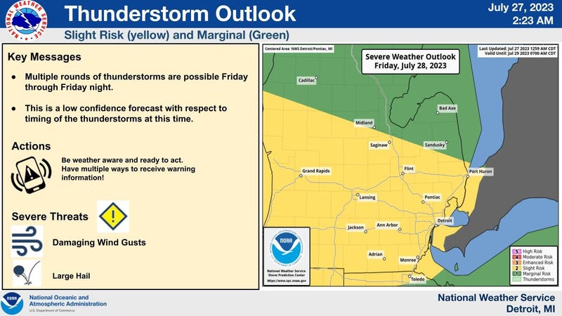
"Multiple rounds of strong to severe storms are possible Friday and Friday night," the National Weather Service said in a 2:30 a.m. update. The biggest threats at this time sound like a broken record for Michiganders — the storms are forecasted to bring damaging winds, large hail and flooding potential.
Experts said the timing of the storms remains to be determined as the forecast becomes clearer, but did warn residents to be prepared.
"Torrential rainfall is expected with any thunderstorms," NWS stated. "There is the potential for multiple round of thunderstorms to impact the same area. Friday night has the best change to see the heaviest rain."
The National Oceanic and Atmospheric Administration (NOAA) gave much of Lower Michigan a "Slight Risk" risk for storms on Friday, July 28. A Slight Risk category means the area could be impacted by organized severe storms that "are not widespread in coverage with varying levels of intensity."
The severe weather is being fueled by a cold front that will push southward across the upper Mississippi Valley and into the Great Lakes as a "mini heat wave" also bakes the region.
AccuWeather meteorologist Dean Devore said Thursday's high will be in the mid to upper 80s, but the heat and humidity will make it feel more like the upper 90s.
Temperatures on Friday afternoon are forecasted to swelter Metro Detroit with AccuWeather Real Feel temperatures reaching 100 to 105 degrees.
According to NOAA, a cluster of storms near the Nebraska/Iowa border will begin to make their way through the Midwest as atmospheric conditions appear to encourage stronger development with the threat of damaging winds.
"A severe risk will probably continue into the late night aided in part by a strengthening west-southwesterly low level jet during the evening across the southwest Great Lakes," NOAA added.
The stifling heat on Thursday combined with Friday's severe weather outlook does not come as welcome news for Michiganders who are without power and must begin the clean-up process after storms hammered Metro Detroit on Wednesday.
DTE's Outage Map reports 162,333 outages across the region at 8 a.m. Thursday with 2,729 crews in the field working to restore power. Even with immediate efforts, energy officials said it may be the end of the day on Saturday, July 29, before everyone gets back online.
WWJ's Mike Campbell reported live from the Redford-Detroit border where massive, mature trees were toppled across streets and vehicles in a hard-hit neighborhood called "The Eye," off of Telegraph Road and Grand River Ave.
Resident Tierra Jordan lives in a home in the area and Campbell said a tree massive snapped about halfway up during the storm and is now "knocking at her front door."
"It's a huge mess," she told Campbell. When asked when her power was estimated to be resorted, she said DTE told her Sunday, July 30
"There was a long pause after that," Campbell reported. "Sunday -- I was surprised that she said they wouldn't get to her until Sunday... I had heard Saturday is the goal and I'm sure DTE will get to it as quick as they can, but there are so many trees down in this neighborhood. It's going to be a while."
Campbell also said Livonia was hit exceptionally hard. When he drove past homes in the area of Fenton near Santa Maria, south of 7 Mile and Grand River, he saw a giant tree that knocked down a light pole and buried a vehicle.
"But miraculously, mostly missed two houses," he said.
Residents took to Facebook to show a multitude of downed trees and damage caused by backyard furniture and even trampolines that were sent flying.
Although not confirmed, one woman is convinced a tornado hit her neighborhood. The woman, who lives on Fairlane, north of Five Mile, says some streets were untouched while others were completely destroyed.
Northeast of Detroit in the Grosse Pointe area, WWJ's Charlie Langton reported much of the same damage Campbell saw.
"Down trees, no traffic lights, generators, tree branches all over the streets. I got stopped a couple of times because I just couldn't get through the street," Langton said he experienced all while going through Grosse Pointe, Grosse Pointe Park and the surrounding areas.
Trees that fell during the storm disabled two main power lines into the Grosse Pointe Pump Station, leading officials to urge residents to take precautions by taking valuables off their basement floors in case of flooding.
Langton said residents were up early to tackle the momumental clean-up, but the scope of the damage is just being revealed as the sun rises.
"I saw one tree literally on top of a house that's not good." Langton said.
Langton reported see a number of DTE crews out working to restore power, along with police just driving around making sure that everyone is OK.
This is a developing story. Stay tuned to WWJ LIFE for full storm coverage plus Traffic & Weather together every ten minutes on the “8s”