
DETROIT (WWJ) -- The Michigan State Police is encouraging Metro Detroiters to start planning for a powerful winter storm expected to strike late in the week.
MSP says the entire state will be under a Winter Storm Watch or warning ahead of the Christmas weekend, with snow, high winds and dangerous cold a concern beginning Thursday night and continuing Friday.
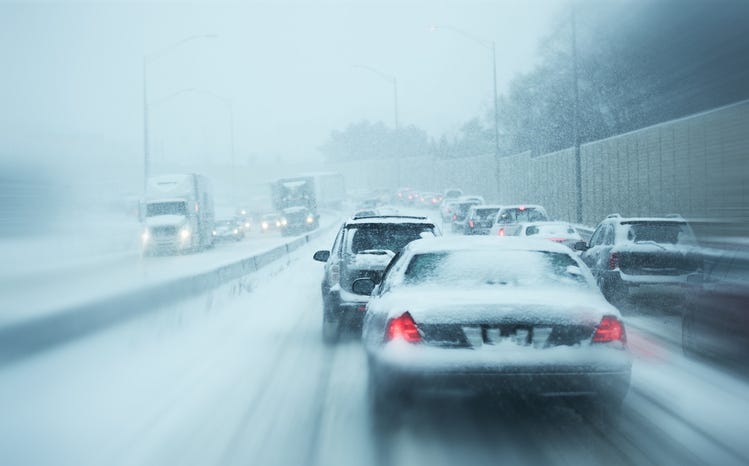
Blizzard conditions are expected to last through Saturday with wind gusts between 40-50 mph and gusts over 60 mph possible at times Friday into Saturday.
AccuWeather Meteorologist Matt Benz says Detroit and its suburbs see half-a-foot of snow by the time things die down.
"It's going to be a significant (storm)," Benz said, speaking live on WWJ Newsradio 950 on Tuesday. "I think that's a pretty safe bet here at this point, at least with regards to impact to travel across much of lower Michigan Thursday into Friday."
Benz said it's all expected to begin with rain on Thursday, mixing with snow as temperatures drop, and then changing over to all snow as it turns sharply colder overnight as the wind picks up.
"And that combination of snow and wind can bring blizzard conditions to the area around Metro Detroit and much of lower Michigan," he said.
Benz said the Metro Detroit area is expected to get "at least 6 inches of snow"; although higher amounts will be possible, depending on the storm track.
Meanwhile, some local businesses, including hair salons, have already announced they'll be closed and are canceling appointments for Friday.
MSP is urging people with places to be to keep the snow in mind and to plan ahead for by checking out the miDrive map. "Please do not call 911 for weather conditions!" the MSP Second District added, in a tweet.
MSP said residents should be sure to have a supply of essential items ready in advance to use during emergencies such as a power outage or being stranded in a vehicle. These supplies should be kept at home, at work and in vehicles for use during an emergency.
“Winter weather can be highly unpredictable, and we encourage residents to start their travel early, if possible, or delay if plans are flexible,” said Capt. Kevin Sweeney, Deputy State Director of Emergency Management and commander of the MSP’s Emergency Management and Homeland Security Division. “The most important thing residents can do to stay safe during extreme weather is to be ready ahead of time by equipping their homes and vehicles with basic emergency preparedness items and developing an emergency plan.”
Winter preparedness tips:
- Develop a 72-hour emergency supply kit that includes essential items like a three-day supply of food and water, a battery-powered or hand-crank weather radio, blankets, flashlights with extra batteries and emergency contact information.
- Know the difference: a Winter Storm Watch means a winter storm is possible in your area; a Winter Storm Warning means a winter storm is occurring or will soon occur in your area.
= Identify a safe alternative heat source and supply of fuel in the event of a power outage.
- Listen to the radio and TV for weather reports and emergency information.
- Stay inside during winter storms. If you must go outside, wear several layers of lightweight clothing, a hat and gloves to prevent loss of body heat. Cover your mouth to protect your lungs.
- For those requiring oxygen, ensure you have a backup power source in case of long-term power outages.
Automotive preparedness tips:
- Carry an emergency supply kit in your vehicle with essential items such as salt, sand, a shovel, food and blankets.
- Ensure your car has the proper mix of antifreeze and water in the cooling system and that windshield washing fluid is topped off.
- Keep tires at the car manufacturer’s recommended pressure and routinely check tire pressure during cold weather.
- Keep the fuel tank near full to prevent freezing of the fuel line.
- When traveling, let someone know your destination, route and expected arrival time.
For those headed out of our area, take note: Forecasters in West Michigan predicting 12 to 17 inches of snow in some areas.
Along with the snow and hazardous driving, the National Weather Service says damaging winds could cause power outages — which could be dangerous as cold as it's gong to get.
On Friday, the forecasted high in the Detroit area is close to 30 degrees, with a forecasted low in the teens, as temperatures plummet heading into the Christmas weekend.
Then Saturday, Christmas Eve, AccuWeather says it's going to be brutally cold, with a high of only around 16 degrees — which will feel more like 4 degrees below zero with the wind chill — and a chance for more blustery snow.
Christmas Day won't be much warmer, with a high of only 19, feeling like the single-digits, and some flurries around.
Before you leave the house, tell your smart speaker "play WWJ nine-fifty" to hear weather and traffic updates every 10 minutes on the 8s. And download the free Audacy App and favorite WWJ to listen to us anywhere, anytime.
Related
