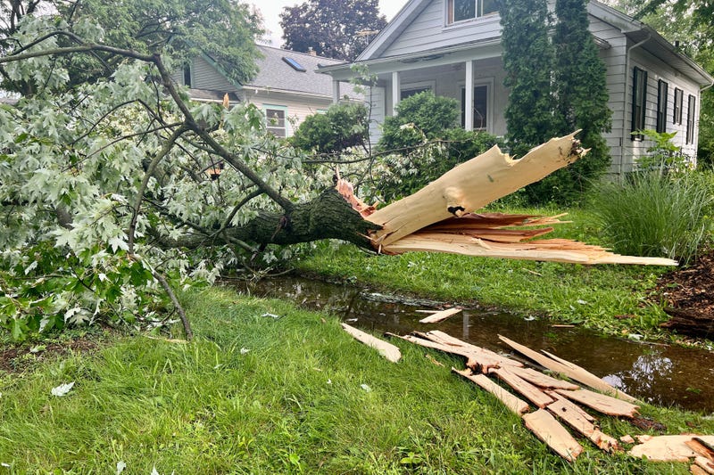

METRO DETROIT (WWJ) - Residents in Southeast Michigan are waking up to no power, scattered debris, flooded roadways and hail damage from Thursday's fast-moving, but hard-hitting storms.
DTE Energy is reporting 60,357 of their customers are without power scattered across their service area as of 10 a.m. The company said 2,159 crews are currently working on restoration efforts.
Since Thursday evening, DTE has brought roughly 12,000 customers back online -- and they plan to have 80% of outages resolved by "end of day Friday, July 21."
"Our crews are working as quickly and safely as possible to restore power to everyone impacted by the extreme weather that hit Southeast Michigan," DTE stated in a storm update. "This storm event resulted in hundreds of 'singles' – jobs in which restoration efforts will result in getting the power back on to a single customer address."
Severe weather blew up across the listening area in the mid-afternoon hours on July 20 as a strong cold front pushed through into Canada. Most of the power outages in Southeast Michigan are concentrated in Oakland County, Wayne County and Macomb County.
The storms brought 70 mph winds, hail the size of tennis balls, heavy rainfall and the formation of several funnel clouds.
DTE said the severe weather mix caused power lines to come down and warned residents to keep their distance.
"We want to make sure the listeners stay safe," DTE said. "Always stay at least 25 feet away from downed power lines or anything in contact with them. Please keep your children away too. Assume any downed line is live and dangerous. Never cross yellow caution tape. Lines may be hidden by tree branches or other debris - be on the lookout after damaging storms."
Drivers in Dearborn, headed into Allen Park, became stranded as a torrential downpour completely flooded the road in both directions. WWJ's Charlie Langton said Friday morning that Oakwood Boulevard under I-94 is still completely underwater.
"Don't go under or don't go on Oakwood Boulevard under I 94," Langton warned. "It is completely flooded in both directions. They've got all kinds of signs there. In fact, on westbound I-94 you cannot get on to the southbound Oakwood exit."
But despite the warnings, Langton said drivers are still attempting to get through, like Dearborn resident Josh Archer.
He got stuck, only to get unstuck, but barely.
"I made it after I started my car a little bit after. Do not go under bridges. You cannot make it," Archer told Langton. "Call your bosses, tell them you'll be late and now I have to go home and change my pants and my shoes for pushing my..."
Langton cut him off, as Archer described how frustrated he was.
"He was not happy getting stuck and getting wet," Langton chuckled.
While flooding rains plagued Wayne County, residents in Genesee County were left to clean up broken glass from busted out windshields when tennis ball-sized hail came smashing down in the mid-afternoon hours.
Davison, between Flint and Lapeer, was hard hit and employees at MMC Collision off State Road were one of many businesses seen by WWJ's Mike Campbell vacuuming up shards and other debris from damaged vehicles in their lot.
"Some of the stuff went right through the roof of this place," Campbell said as he saw multiple vehicles at the business with bags over their busted windows.
Resident Amy Willett’s told Campbell that she was on her way to work when she was struck by what she says were "big balls."
"Yeah, it was pelting down pretty hard, kind of like a tennis court when all the tennis balls are falling, kind of like that," she told Campbell.
Willett’s car rear window was shattered and her home skylights were cracked and siding damaged. Campbell said the hailstones were about two and a half inches in diameter.
WWJ's Dean DeVore said the rest of the weekend should remain quiet and pleasant after Thursday's storms. Friday will have times of clouds and sun with a rain shower possible in some spots in the afternoon hours, especially up toward the thumb. The highs are expected to reach 81.
Friday night will be clear to partly cloudy, but comfortable with a low of 62 degrees.
Plenty of sun with some clouds are forecasted for Saturday and Sunday. The next chance for a thunderstorm comes around on Sunday afternoon. Highs for both days are expected to reach 82.