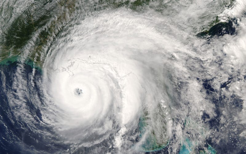

Hurricane Ida is expected to make landfall in Louisiana Sunday as a catastrophic Category 4 hurricane, bringing deadly weather conditions as it crosses over Southern Louisiana, WWL-TV reported.
For live updates on the hurricane and important information for the area check back here.
5:30 p.m.
Our partners at the Times-Picayune | New Orleans Advocate report that Thibodaux Regional Medical Center's ICU had a generator failure amid Hurricane Ida's impacts. Patients had to be transported via a stairwell to another part of the hospital with power, WWL-TV reported.
5:15 p.m.
A Flash Flood Emergency has been issued for the Braithwaite are of Plaquemines Parish. Levees in the area have significantly overtopped on the eastbank of the parish between the parish line and White Ditch.
If anybody is in that area, they need to seek higher ground immediately.
5 p.m.
New Orleans firefighters responded to a 2-alarm fire on Rampart Street during Hurricane Ida after elevator motors on the fifth floor of a building caught fire.
It's unclear exactly when the fire broke out, but most emergency responders have by now begun sheltering in place from life-threatening winds across the city.
4:55 p.m.
Hurricane Ida appears to be stalling over Southeast Louisiana, which is bad news for just about everybody currently in its path. Ida is holding its strength as a strong Category 4 storm in lower Terrebonne Parish.
Rain will continue to fall at a rate of 3-4 inches per hour until the storm either passes or weakens.
Devastating winds are expected to continue through the foreseeable future.
4:45 p.m.
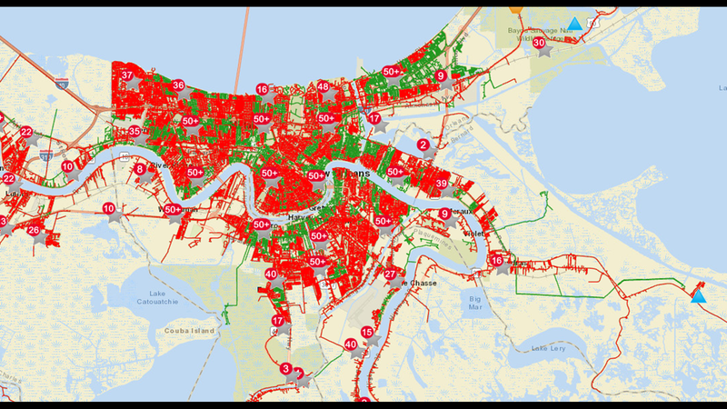
More of New Orleans is red on Entergy's Outage map than green, indicating most of the city is without power even before the worst of Hurricane Ida reaches the city. Entergy lists about 122,000 customers without power in the parish.
Across the state, just under 480,000 customers are currently without power, nearing the outage totals from Hurricane Zeta last year.
Power companies report outages in terms of customers. Each customer represents a building. Some of those buildings are likely empty as people have evacuated ahead of the storm and closed businesses, but others will have multiple people inside them.
4:35 p.m.
All parts of Terrebonne Parish east and south of the Gulf Intracoastal Waterway (GIWW) are now under a boil water advisory because of problems caused by Hurricane Ida.
4:20 p.m.
The city of New Orleans is planning a post-storm evacuation plan after Hurricane Ida has passed. Anybody interested in serving as a volunteer for that effort in any capacity can sign up to do so here.
4 p.m.
S&WB officials now say 24 of the 84 sewer lift pumps in New Orleans are without power.
These are not the drainage pumps that drain water from the city.
Instead, these pumps regulate wastewater disposal throughout the city. With some down, there is a chance for sewage backflow into homes nearby.
3:50 p.m.
There are more than 420,000 Entergy customers without power across Louisiana. That number is expected to grow even higher as Hurricane Ida continues to make its way over land towards Baton Rouge.
During Hurricane Zeta last year, 480,000 people were without power at the height of outages.
3:45 p.m.
Despite making landfall nearly four hours ago, Ida shows no signs of weakening as it slows over the marshy areas of south Terrebonne Parish.
Baton Rouge isn't expected to see major impacts until around 7 p.m., meaning there are still many long hours ahead for Southeast Louisiana as the storm passes overhead.
3:35 p.m.
The ferry that broke loose from its mooring in Chalmette is one of the newest in the fleet. It only went into service last year and cost at least $10 million.
The boat appears to have become grounded.
Emergency tug boats have been assigned to recover it as soon as conditions are safe to do so.
3:05 p.m.
President Joe Biden is promising the full resources of the federal government to recovery efforts after Hurricane Ida.
FEMA is staged to assist the state in the storm's aftermath.
3 p.m.
St. James Parish is implementing a curfew at 4 p.m. Sunday. It will remain in place until sunup Monday morning. Residents should not be out on the street until after Hurricane Ida has passed.
2:55 p.m.
NOPD officers responded to reports of a stabbing at an apartment complex on the North I-10 Service Road Sunday amid rapidly deteriorating conditions in New Orleans. A woman at the location had been stabbed in the back.
According to Ramon Vargas with the Times-Picayune | New Orleans Advocate, the officers took the woman to the hospital themselves because EMS was not able to get to the scene because of the weather conditions.
This is one of the last emergency calls that NOPD officers will be able to respond to until Hurricane Ida has passed.
2:55 p.m.
Footage from St. Bernard Parish Coastal Director Jane Lane shows the passenger ferry that drifted free near Chalmette earlier today.
2:50 p.m.
Video from the St. Bernard Parish shows the outside of the Delacroix fire station one hour before and after Hurricane Ida hit land. The security footage shows the flooding that happened within one hour.
2:45 p.m.
New Orleans is seeing consistent 70 MPH gusts as Hurricane Ida continues north. Wind speeds are expected to rise further through the rest of the day.
2:35 p.m.
St. Bernard Parish President Guy Mcinnis confirmed that the RTA pedestrian ferry was the ferry that got loose of its mooring. The ferry is usually docked across from the Chalmette Ferry terminal.
It's unclear if any of the surrounding levees are at risk from the drifting ferry.
2:15 p.m.
Gov. Edwards says there are about 1,500 people sheltering in 23 emergency shelters throughout the state, and that number could grow in the aftermath of the storm as people assess the damage caused by Hurricane Ida.
2:10 p.m.
Gov. John Bel Edwards is urging residents to avoid sightseeing in the immediate aftermath of Hurricane Ida. Downed power lines, debris and other potentially hidden dangers could be deadly to anybody who ventures out after the storm.
2 p.m.
The Chalmette Ferry has broken loose of its mooring and is currently headed upriver on the Mississippi. The ferry is near Mile Marker 90, and officials say there is nothing that can be done to stop it until the storm passes.
1:55 p.m.
Any reports of a major oil facility in the Gulf of Mexico having issues are unconfirmed. Shell cannot determine if any of those reports are true until after the storm has passed and they can conduct a damage assessment.
However, officials confirmed to WWL-TV that the platform was evacuated ahead of Ida and all oil wells are shut down.
1:30 p.m.
More than 230,000 customers across Louisiana are without power as Hurricane Ida continues to march slowly across the state.
About 64,000 of those outages are in New Orleans, with another 75,000 in Jefferson Parish.
Even more outages are expected throughout the day, with estimated restoration times for some areas stretching into the weeks.
1:15 p.m.
There have been calls for rescue on Grand Isle, but because of deteriorating weather conditions and flooding on Highway 1, Parish President Cynthia Lee Sheng says the people still on the island — about 40 people — will need to wait it out until the storm passes.
1:10 p.m.
Kenner police have been asked to shelter in place as hurricane force winds from Ida continue to whip through the southeastern part of the state.
It now seems that for the next several hours, or until the storm from Ida subsides, residents will not be able to receive help from emergency responders.
12:50 p.m.
Washington Parish will be placed under a parish-wide curfew at 5 p.m. that will last through 7 a.m. Monday. No one will be allowed out on the streets unless they are responders, medical emergency or required to report to work.
All parish residents should seek shelter and stay there until Hurricane Ida has passed.
12:35 p.m.
There are now at least 130,500 customers without power across Southeast Louisiana. Widespread outages could last for weeks.
Some parish officials have said they expect outages to last 25 days or more.
12:30 p.m.
A Twitter user in the path of Hurricane Ida posted a video, possibly from Grand Isle, showing a tree becoming uprooted by the winds and floodwaters.
Other residents in the area have released video footage fo the rain and winds whipping into houses.
Noon
Hurricane Ida has made landfall near Port Fourchon. Shelter in place.
11:55 a.m.
All emergency services in New Orleans have been suspended until Hurricane Ida has passed. No emergency calls will be answered in the city by NOPD, NOFD or EMS until conditions improve.
11:45 a.m.
All emergency responders in Lafourche Parish have begun to shelter in place, meaning they will not respond to calls until the storm has passed.
Other parishes are expected to begin similar procedures as the storm reaches land and begins passing over Louisiana.
11:40 a.m.
Mayor LaToya Cantrell says New Orleans could experience deadly winds as Hurricane Ida makes landfall.
Parish officials warned that because of the winds, emergency responders would be unable to respond to calls until the storm passes.
“There’s nobody coming to help right now,” said Collin Arnold, the city's director of emergency management.
11:30 a.m.
Several Sewerage and Water Board sewer pump stations are without power on both the eastbank and westbank.
These are not the drainage pumps that pump water out of the city.
The sewer pumps being out means there is potential for sewer backups in homes. Anybody with power is being asked to reduce the amount of wastewater leaving their homes by not running the dishwasher or washing machine.
11:25 a.m.
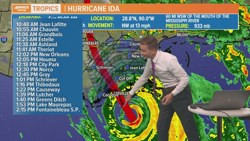
WWL-TV has released a timeline of when to expect the worst from Hurricane Ida in your area.
11:10 a.m.
The inner eyewall of Hurricane Ida is making landfall over Port Fourchon. The center of the storm is going to reach the Louisiana coast within the next hour.
10:45 a.m.
Former WWL-TV Chief Meteorologist Carl Arredondo is seeing an outer band from Hurricane Ida all the way on the Florida coast.
Here's his view from the Fort Walton beach.
10:35 a.m.
Tangipahoa Parish will be placed under a mandatory curfew at 9 p.m. that will be in place until Monday at 10 a.m.
Parish officials urge everybody to stay inside and hunker in place. The time to evacuate has passed, and anybody still in the parish should prepare for hurricane-force winds and heavy rainfall.
10:30 a.m.
9-1-1 service is back online in New Orleans after a brief outage. Residents who need to call in an emergency should be able to do so with no complications.
However, emergency responders could be delayed or stopped by weather conditions, meaning they may not be able to immediately respond to all calls.
10:25 a.m.
St. Tammany Parish President Mike Cooper says a curfew will begin across the parish at noon and will last until further notice. Nobody should be outside while Hurricane Ida is passing through Louisiana.
10:20 a.m.
Slidell police say no businesses are open in the city, including gas stations. Several red lights have gone out, and more are expected to go down in the next few hours.
Police say that once winds reach a certain speed, it will be difficult for officers to respond to emergencies, and in certain circumstances may be impossible until conditions improve.
Residents should shelter in place until after Hurricane Ida has passed.
10:10 a.m.
St. Bernard Parish President Guy Mcinnis posted a video shortly after talking with WWL-TV where he showed the ring levees around Delacroix that are about to overtop.
He said they are expected to overtop by about 5-6 feet and to stay overtopped for another 12 hours at least.
10 a.m.
9-1-1 is experiencing technical difficulties in New Orleans, according to the Orleans Parish Communications District.
Residents who need to report an emergency should call 504-821-2222.
City officials said Saturday they expect emergency response service to be spotty for at least the first 72 hours after the storm because of dangerous conditions and blocked roads.
9:40 a.m.
St. Bernard Parish President Guy Mcinnis says some levees in the parish are close to overtopping.
Ring levees around Delacroix about to overtop, Mcinnis told WWL-TV.
The storm surge in the parish is about 6-8 feet, with higher surges expected in the coming hours.
9:35 a.m.
The Causeway will close at 11 a.m. because of high winds, bridge officials say.
Winds of up to 50 MPH have been clocked over Lake Pontchartrain.
9 a.m.
Hurricane Ida is continuing its trek towards Louisiana's coast, with an expected landfall somewhere near Port Fourchon. Landfall is expected sometime around noon.
Winds are picking up throughout the coastal parishes, with gusts beginning to jump up further inland. The worst weather is still expected to be through Sunday afternoon.
8:35 a.m.
Terrebonne Parish President Gordon Dove urged residents living in mobile homes of any kind to evacuate immediately ahead of winds up to 150 MPH expected in the parish Sunday night.
if you live in a trailer, if you live in a motor home, you live in a travel trailer, get out," Dove said. "Don't even think, even if you've got straps, that's not going to hold against that monster coming after us. This thing is bad and we are urging people to get out of these mobile homes because that's nothing to play with. They're going to blow apart."
He urged any residents with nowhere to go to contact the parish for accommodations. Terrebonne Parish has partnered with a number of hotels to house those displaced ahead of the storm.
8:20 a.m.
St. Charles Parish has set up two areas as a refuge of last resort:
Edward A Dufresne Community Center at 274 Judge Edward A. Dufresne Parkway (West Bank)
Harry Hurst Middle School gym located at 170 Road Runner Lane in Destrehan (East Bank)
Those who are unable to shelter anywhere else should go to the nearest of those locations immediately.
For a full list of shelters across Southeast Louisiana, click here.
8:10 a.m.
Here's the latest update on Hurricane Ida, expected to make landfall around noon as a devastating Category 4 hurricane.
7:55 a.m.
An Extreme Wind Warning has been issued for much of Southeast Louisiana. Winds over 115 MPH will begin in the area within the next hour. Residents are advised to treat the storm like a tornado and to take shelter in a sturdy structure away from windows.
7:35 a.m.
On Grand Isle, where power was just lost, water and wind are surging in.
Councilman Ricky Templet evacuated from the island, but sent WWL-TV some video showing the ferocity of the storm's outer bands.
Some residents have decided to stay, despite the mandatory evacuation order.