
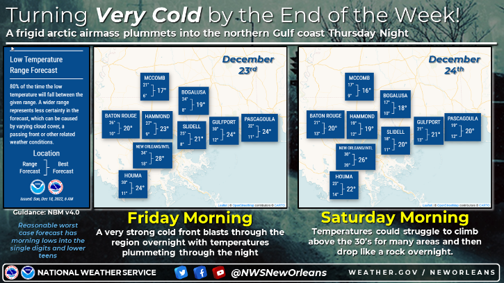
By the end of this week Arctic air blasts into the deep south, plunging temperature for Southeast Louisiana just in time for Christmas.
"A strong Arctic cold front charges in late Thursday," according to WWL TV Meteorologist Payton Malone. "This one will bring freezing conditions for three nights in a row starting Thursday night."
He says a hard freeze looks likely on Christmas Eve morning both north and south of the lake.
"Make sure any exposed outdoor pipes are protected before Thursday."
Lows on Christmas Eve Saturday will be in the teens on the Northshore and away from the city with low 20s in the New Orleans metro area.
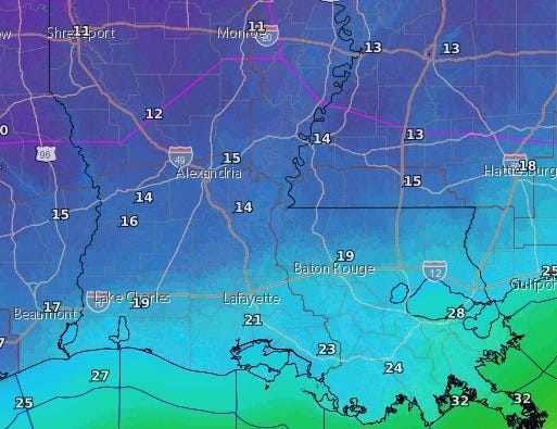
Before that we get rain.
"This week starts cold and rainy ahead of the blast of frigid air," Malone forecasts. "Expect cloudy skies and a chilly feel for Monday with an east breeze. Showers will spread in during the afternoon."
Rain will continue overnight tonight, with showers lingering on Tuesday.
Could we see snow? Malone says there is a small chance.
"There is a low-end potential for a little wintry precipitation very late Thursday night as the cold front sweeps in. We're several days out, so models are swinging back and forth about whether we'll get any precipitation at all... and if we do, whether it will come in frozen form or just a cold rain."
He stresses the forecast is uncertain.
"Models are hinting at some cold rain, snowflakes or a wintry mix for our northern areas into Mississippi. Timing would be a brief window very late Thursday night. Overall, we wouldn't expect any big issue from this, but something we'll watch."
Detailed Forecast...
TODAY:
Mostly cloudy and breezy. 80% chance of scattered showers in the afternoon and evening, more overnight. Low: S 46, N 35. High: 55.
TUESDAY:
60% chance of showers. Mostly cloudy, chilly and windy. Low: S 50, N 45. High: 55.
WEDNESDAY:
Mostly cloudy and chilly. Low: S 49, N 44. High: 59.
THURSDAY:
Mostly cloudy and cool. 20% chance of rain, possibly wintry mix late? Low: S 53, N 48. High: 64.
FRIDAY:
Hard freeze north and west of the lake, light to moderate freeze south of the lake. Sunny, very cold and windy. Low: S 30, N 24. High: 34.
CHRISTMAS EVE:
Hard freeze for entire area - north and south of the lake. Sunny, very cold and breezy. Lows: N 16, S 23. High: 37.
CHRISTMAS DAY:
Hard freeze north and west of the lake, light to moderate freeze south of the lake. Partly cloudy and cold. Low: S 28, N 21. High: 41.