PORTLAND, Ore. (AP) — The first of a series of powerful storms dumped heavy rain and swelled rivers in the Pacific Northwest on Tuesday, closing roads and prompting high water rescues.
Residents in parts of Oregon and Washington grappled with power outages, flooding and school closures, while drivers navigated debris slides and water that closed roads and submerged vehicles.
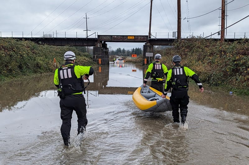
Fire officials northeast of Seattle said crews conducted several rescues, using inflatable kayaks to pull people from stranded cars and carrying another person about a mile (1.6 km) to safety after they were trapped in a wooded area by rising water.
Forecasters warned that the worst was still to come, with some major rivers expected to crest later in the week.
“We're starting to see a lot of rivers begin to rise and move very rapidly with lots of runoff with the rain,” said Harrison Rademacher, a meteorologist with the National Weather Service's Seattle office.
Rademacher described the atmospheric river soaking the region as “a jet stream of moisture” stretching all the way across the Pacific Ocean “with the nozzle pushing right along the coast of Oregon and Washington.”
The National Weather Service’s Weather Prediction Center forecast several days of heavy rainfall along the coast and more than a foot of new snow in the northern Rockies in northwestern Wyoming. Flood watches were in effect with scattered flash flooding possible along the coast and into the Cascade Mountains through midweek.
Police said deputies went door-to-door in certain neighborhoods to warn residents of imminent flooding, including evacuating a mobile home park along the Snohomish River northeast of Seattle. In Auburn, south of Seattle, workers installed temporary flood control barriers along the White River.
Another storm system is expected to bring rain to the region starting Sunday, said Rademacher. “The pattern looks pretty unsettled going up to the holidays,” he said.
Portland transportation officials warned of an increased risk of car crashes due to hydroplaning or driving through flooded roads.
Further north, an arctic blast is affecting parts of southeast Alaska, with wind chills possibly hitting as low as minus 50 degrees (minus 45.6 Celsius) in Skagway, minus 25 (minus 31.6 Celsius) in Haines and minus 15 degrees (minus 26 C) in Alaska’s capital city, Juneau, according to the National Weather Service.
Meanwhile, a fast-moving storm tracking across the Upper Midwest on Tuesday was forecast to bring freezing rain, high winds and heavy snow.
Much of North Dakota was under a no-travel advisory due to freezing rain and slippery roads. Some schools closed or moved to virtual lessons due to the weather conditions.
Most of Montana and the Dakotas were under a high wind warning. Winds of up to 65 mph (105 kph) were expected Tuesday, said Connor Smith, meteorologist for the National Weather Service in Bismarck. High winds could make travel difficult and blow around unsecured objects, Christmas decorations and already fallen snow, he said.
Wintry weather was also expected to impact the evening commute in Minnesota and northwest Wisconsin, starting Tuesday afternoon and lasting into the night, said Ryan Dunleavy, meteorologist for the National Weather Service in the Twin Cities. Parts of central and northern Minnesota and northwest Wisconsin could see heavy snow, with a mix of winter weather forecast across the Twin Cities metro and southwest Minnesota, with potentially strong winds to follow, Dunleavy said.
Commuters should allow for extra time traveling, he said. The storm is expected to head into the Great Lakes region by Wednesday.