
A brief warm up today, another cold front early tomorrow drops temperatures once again, clouds invade tomorrow and stick around through late Saturday, a slight chance of snow flurries before noon Saturday, remaining cool through Monday, and we may hit 60° by next Tuesday and Wednesday. Those are your weather stories over the next 7 days.
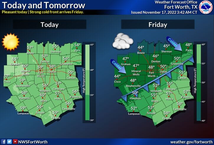
Temperatures have fallen into the upper 20s to mid 30s across North Texas this morning. You'll definitely need a jacket. Plenty of sunshine will be seen today with high temperatures near 60°. Enjoy, because another cold front will arrive before noon tomorrow, dropping high temperatures into the 40s again.
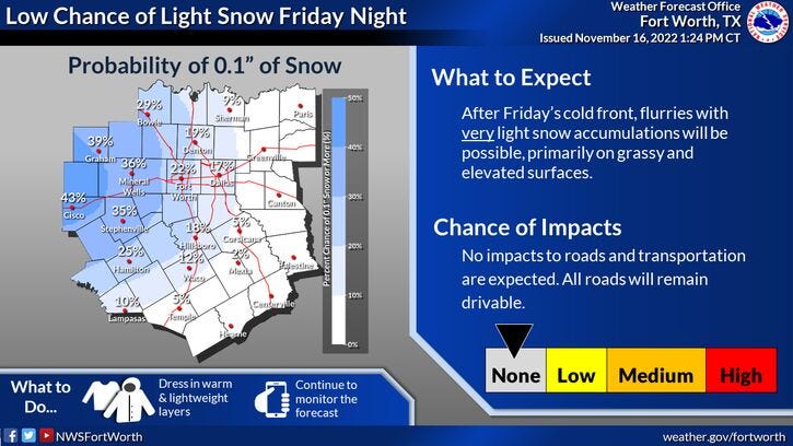
Clouds will also increase through the day, but no precipitation is expected until possibly after midnight into Saturday morning. There's a very slight chance of some light snow, especially just west and north of DFW Saturday morning. It's not out of the question that we could see some flakes flying across the Metroplex, but no accumulations are expected. However, there may be a light dusting on the grass and rooftops off to our west. Morning lows on Saturday will range between 30 and 34° with afternoon highs in the low to mid 40s. Clouds will move out by Saturday evening.
Sunday looks nice but remains on the cool side. Plenty of sunshine with highs in the low 50s.
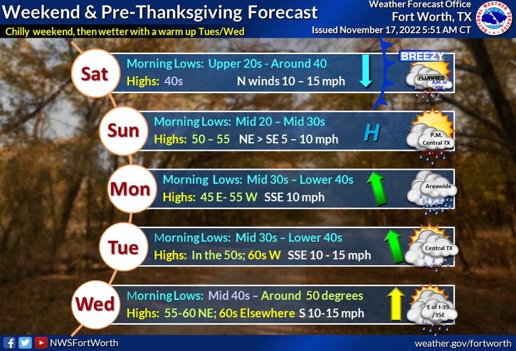
Clouds will increase Sunday night and into Monday. There's a very slight chance of a morning shower on Monday and it will remain cool with highs in the low 50s.
Skies will briefly clear on Tuesday, we might even hit the 60° mark. By Wednesday, clouds will be on the increase again with a slight chance for a shower. Afternoon highs will warm to near 60°.
As far as Thanksgiving goes, model data is all over the place. Some data suggests we'll see rain, others keep it dry.
*Yest Rain: 0.00"; High: 56; Low: 38
*Today’s Averages: High: 66; Low: 46
*Record high: 87 (1938, 2013); Record low: 20 (1959)
*November rain: 4.01"; Surplus: 2.50"
*2022 Rain: 31.86”; 2022 deficit: 1.29"
*Sunrise: 7:00am; Sunset: 5:26pm
Today: Passing high clouds and a bit warmer. High: Upper 50s. Wind: SW 5 mph.
Tonight: Leonid Meteor Showers peaking. Mostly clear and chilly. Low: 33-40. Protect plants and pets. Wind: Lt. var.
Friday: Late morning cold front. Increasing clouds and cold. High: Upper 40s early, then slowly falling temperatures through the day. Wind: NE 10-15 mph.
Saturday: Cloudy and cold. Morning flurries/light rain. No accumulations. Clearing late. Low: 29-33; High: Low to mid 40s.
Sunday: Sunny, continued cool. High: Low 50s.
Monday: Mostly to partly cloudy and cool. Slight chance of morning showers. High: Low 50s.
Tuesday: Partly cloudy and a bit warmer. High: Near 60.
Wednesday: Mostly cloudy. Slight chance of showers. High: Near 60.
Related

LISTEN on the Audacy App
Tell your Smart Speaker to "PLAY 1080 KRLD"
Sign Up and Follow NewsRadio 1080 KRLD