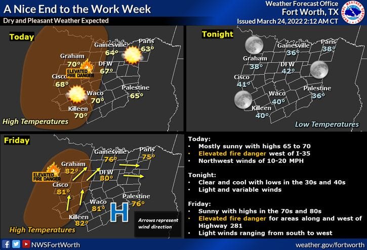

One more day today with below average temperatures and then readings will warm into the eighties this weekend and into early next week. Unfortunately, the grass fire danger returns today through the weekend as well, mainly west of I-35W.
By Monday and Tuesday, humidity levels will start to rise ahead of our next weather maker. This system is due to arrive late Tuesday into the 1st half of Wednesday. Unfortunately, there is a threat for strong to severe thunderstorms again. As we get closer to our next event, I will spell out the timeline, the severe threats, and rainfall amounts to be expected.
In the meantime, enjoy the warmer temperatures, but please be mindful of the elevated fire danger west of Fort Worth through the weekend and into early next week.
*Yest Rain: 0.00”; *Yest High: 64; Low: 46
*Today’s Averages: High: 71; Low: 50
*Record high: 89 (1929, 2018); Record low: 30 (2006)
*February rain: 1.18”; March deficit: 1.29"
*2022 Rain: 3.29”; 2022 deficit: 4.47"
*Sunrise: 7:25 am; Sunset: 7:43pm
Today: Mostly sunny, breezy and cool. Elevated grass fire danger west of I-35W. High: Upper 60s. Wind: WNW 15-25 mph
Tonight: Clear and chilly. Protect tender vegetation. Low: 40-45. Wind: NW 5-10 mph.
Tomorrow: Sunny and warmer. High: Upper 70s. Wind: WNW 5-10 mph.
Weekend: Passing high clouds, windy and warm. Elevated grass fire danger, especially west of I-35W. High: Low to mid 80s.
Monday and Tuesday: Partly to mostly cloudy, windy and VERY warm. Increasing humidity. High: Mid to upper 80s.
Wednesday: Morning strong to severe storms, afternoon clearing. Breezy and a bit cooler. High: Mid 70s.
Related

LISTEN on the Audacy App
Sign Up and Follow NewsRadio 1080 KRLD