
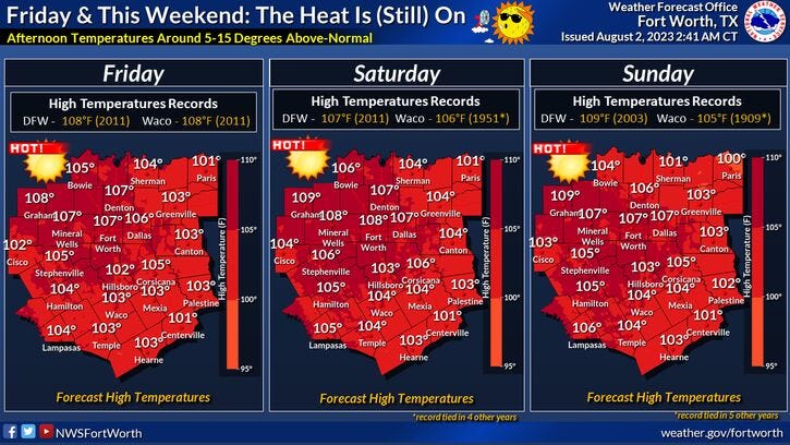
North Texas tied the record high temperature yesterday of 107° and unfortunately this relentless heat will continue through the weekend. We'll also be flirting with record highs Friday, Saturday, and Sunday.
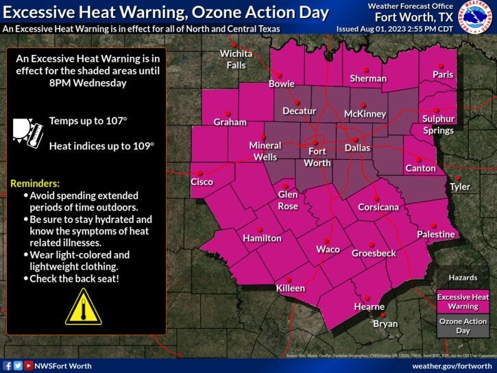
An Excessive Heat Warning is in effect today and will most likely be extended into the weekend as well.
Afternoon highs tomorrow through Sunday will range between 106° and 108°. Grass fire danger will also remain high throughout the period, especially west of I-35W.
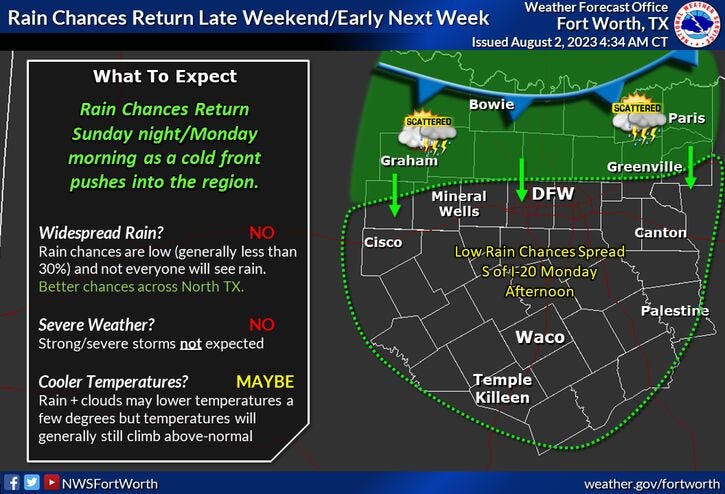
I'm still monitoring the potential for a weak cold front to slide through the area early next week, dropping temperatures into the upper 90s. There is also a slight chance of rain Monday and Tuesday.
*Yest Rain: 0.00"; Yest High: 107R Low: 81
*Today’s Averages: High: 97; Low: 77
*Record high: 110 (2011): Record low: 62 (1965)
*August Rain: 0.00"; Deficit: 0.05
*2023 Rain: 14.83"; Deficit: 7.59"
*Sunrise: 6:42am; Sunset: 8:26pm
Today: *Excessive Heat Warning; Air Quality Alert* Mostly sunny, breezy and hot! High: 107. Grass fire danger. Wind: SSW 10-20 mph.
Tonight: Clear and warm. Low: 78-82. Wind: South 10-20 mph.
Thursday: *Excessive Heat Warning likely* Mostly sunny, breezy and hot. High: 106. Grass fire danger. Wind: SSW 10-20 mph.
Friday: *Excessive Heat Warning likely* Sunny, breezy, and hot. Near record (108) heat. Grass fire danger. High: 106.
Saturday: *Excessive Heat Warning likely* Partly cloudy and hot. Near record (107) heat. High: 107.
Sunday: *Excessive Heat Warning likely* Partly cloudy, continued hot. Near record (109) heat. High: 108.
Monday and Tuesday: Partly cloudy and a bit cooler. Isolated showers and storms. Highs: Mid to upper 90s.
Related

LISTEN on the Audacy App
Tell your Smart Speaker to "PLAY 1080 KRLD"
Sign Up to receive our KRLD Insider Newsletter for more news