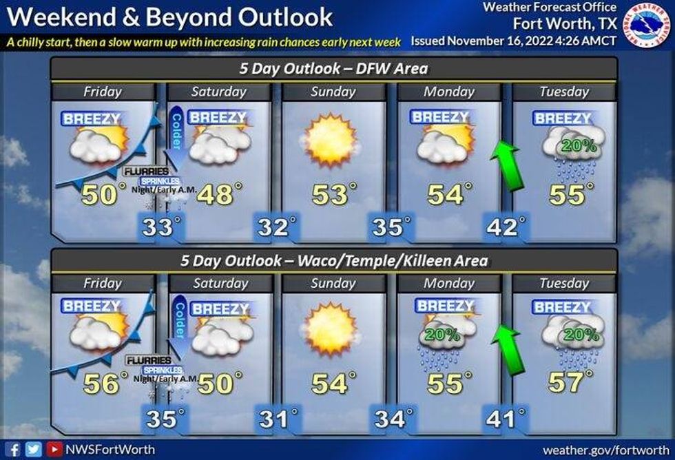
Another week is cruising by and temperatures continue to be very cold for this time of the year. We'll continue to feel below average temperatures over the next 7 days, experience another cold front from the Arctic on Friday, and there's a very slight chance of a snow flurry or two early Saturday morning while you're sleeping. Those are your weather stories over the next 7 days.
We're waking up to temperatures in the 30s again this morning, but the wind is much lighter. High clouds will continue to stream overhead through the day today with afternoon highs only reaching the low 50s. Our average high is 66°!
Tomorrow will actually be our warmest day for a while as readings jump up into the upper 50s. It'll feel like summer again. Not..
Sometime around lunch time on Friday, another arctic cold front will settle into the area. Some areas may get up into the low 50s before temperatures slowly tumble through the 40s through the late afternoon and evening. Clouds will also increase Friday evening as an upper level disturbance approaches. This disturbance will bring some light snow to the Panhandle and Big Country Friday evening. And, it's not out of the question that we see a few snow flurries around North Texas while you're sleeping into Saturday morning. Chances are very slim, but it is possible.
 National Weather Service - Fort Worth
Very dry air and unseasonably cool temperatures will dominate us through the weekend. Saturday will remain mostly cloudy with highs only in the mid-40s. Sunshine will return on Sunday, but it'll still be chilly with readings in the low 50s. A slow warm-up is in store into next week with highs back in the mid 50s on Monday and Tuesday.
It's still too early to accurately forecast what the weather will be like for Thanksgiving, but some of the extended model data is hinting at a very rainy Thanksgiving.
*Yest Rain: 0.00"; High: 46; Low: 37
*Today's Averages: High: 66; Low: 46
*Record high: 87 (2016); Record low: 24 (1920, 1932, 1997)
*November rain: 4.01"; Surplus: 2.58"
*2022 Rain: 31.86"; 2022 deficit: 1.21"
*Sunrise: 6:59am; Sunset: 5:26pm
Today: Passing high clouds and cool. High: Low 50s. Wind: NNW 5-10 mph.
Tonight: Partly cloudy and cold. Low: Low to mid 30s. Protect plants and pets. Wind: Lt. var.
Thursday: Mostly sunny, a tad warmer. High: Mid to upper 50s. Wind: SSW 5-10 mph.
Friday: Increasing clouds, turning windy and colder by afternoon. High: Low 50s early, then falling temperatures through the 40s. WInd chills in the 30s by evening.
Saturday: Morning flurries? Mostly cloudy and chilly. Clearing late. High: Mid 40s.
Sunday: Sunny, continued cool. High: Low 50s.
Monday: Mostly sunny and cool. High: Mid 50s.
Tuesday: Increasing clouds and cool. High: Mid to upper 50s.
LISTEN on the Audacy App
Tell your Smart Speaker to "PLAY 1080 KRLD"
Sign Up and Follow NewsRadio 1080 KRLD