
Weather radar above courtesy of our news media partners at NBCDFW
UPDATE: 3:50 p.m. A Severe Thunderstorm Watch has been issued for the until 10 p.m. Wednesday for the following counties: Collin, Cooke, Dallas, Delta, Denton, Fannin, Grayson, Hunt, Jack, Lamar, Montague, Parker, Rockwall, Tarrant, and Wise.
Here are your weather stories over the next 7 days… isolated severe weather late this afternoon through the evening, turning sharply colder before you wake up tomorrow morning, more wind, it stays cool through Saturday, but a rapid warm up will take place Sunday and especially into Monday and Tuesday of next week.
We're starting off this morning in the 40s across north Texas. Most of the day will be decent with plenty of sunshine, more wind, with afternoon highs near 80゚!!
I'll also be keeping an eye on the radar to the west of DFW between 4 PM and 7 PM, in the heart of the Metroplex between 7 PM and 9 PM, an area's east of Dallas from 9 PM to midnight. Please keep in mind, a lot of you won't see a drop of rain, but one or two storms may become severe with large hail, damaging wind, and an isolated tornado being the threats. I will be watching!
In other news, winter returns bigtime before you wake up tomorrow morning, as a strong cold front plows through the area. You'll wake up to temperatures in the mid to upper 30s, with wind chills in the 20s, as north winds gust to 35mph. Wind gusts to 40mph are possible through the day, as highs struggle to get above 45゚. Wind chills will be in the 30s all day long... BRRRRRR!
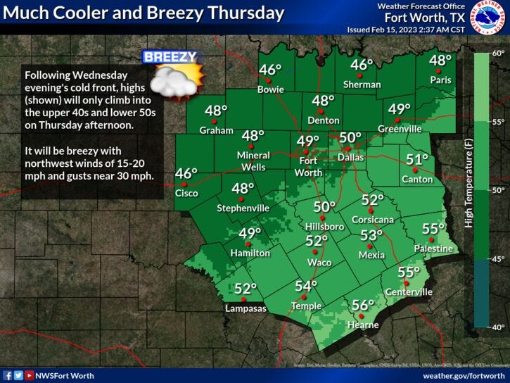
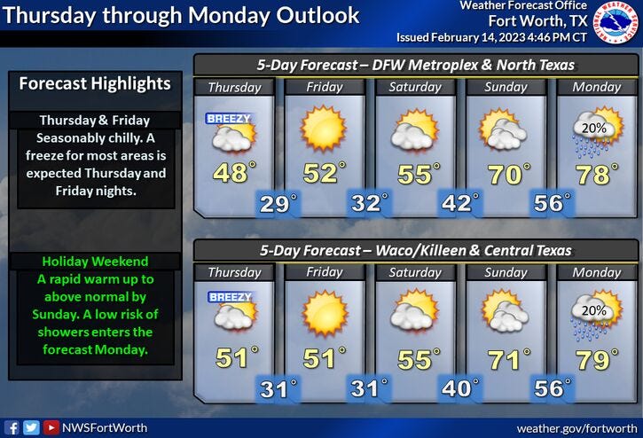
A pretty hard freeze is expected on Friday morning, as temperatures fall into the mid to upper 20s. Plenty of sunshine and less wind will greet you on Friday, but temperatures will remain below average. I am forecasting highs in the low 50s. Mid to upper 50s with high clouds is expected on Saturday, near 70゚ with wind and high clouds on Sunday, and believe it or not, will be approaching the 80゚ mark next Monday and Tuesday with a gusty southerly wind.
Stay weather aware late this afternoon into the evening hours, and again I will be watching things closely just in case one or two storms becomes severe. Have a terrific day and please enjoy the weather when you can, it's the only way that you've got!
7-Day Headlines:
* DFW reached 71 degrees yesterday.
* Warm and windy today.
* Isolated severe threat from 4pm-10pm today.
* Turning windy and MUCH colder early Thursday morning.
* 40s tomorrow, 50s Friday and Saturday.
* Big warm up Sunday-Tuesday.
*Yest Rain: 0.58"; High: 71; Low: 53
*Today’s Averages: High: 61; Low: 40
*Record high: 83 (2005); Record low: 4 (2021)
*February Rain: 3.48"; Surplus: 2.23"
*2023 Rain: 4.86"; Surplus: 1.08"
*Sunrise: 7:12am; Sunset: 6:13pm
Looking Ahead:
Today: Mostly sunny, windy and warm. Scattered strong to severe storms by late afternoon into the evening (4pm to 10pm from west to east). Threat level: 2 (slight) out of 5 . Storm threats: Large hail, damaging wind and isolated tornadoes. Turning windy and much colder after midnight. High: Near 80. Wind: South 15-25, G30 mph.
Tonight: Decreasing clouds, windy and colder after midnight. Low: Mid to upper 30s. Wind chills in the 20s. Wind: NNW 20-30, G35 mph.
Thursday: Sunny, windy and cold. High: Mid 40s. Wind chills in the 30s. Wind: NNW 20-30, G40 mph.
Friday: Sunny and cool. Less wind. High: Low 50s.
Saturday: Passing high clouds and seasonable. High: Mid to upper 50s.
Sunday: Passing high clouds, breezy and warmer. High: Near 70.
Monday: Partly cloudy, windy and VERY warm. High: Near 80.
Related

LISTEN on the Audacy App
Tell your Smart Speaker to "PLAY 1080 KRLD"
Sign Up and Follow NewsRadio 1080 KRLD