
Winter makes a brief return today and tomorrow and then seasonable temperatures are expected the last 5 days of your 7 day forecast! Some of you lucky ones may see a few showers around on Saturday, especially east of DFW. You want some widespread rain? As of now, it looks like late Wednesday through the end of next week may be a little cold and wet.

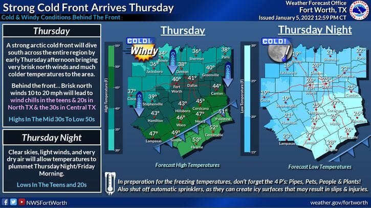
In the meantime, the Arctic cold front is now moving through north Texas. Temperatures will continue to fall a little below freezing over the next few hours across North Texas. Wind will pick up by late morning and start gusting to 30 mph. This will create wind chills in the upper teens to low twenties all day long, even with abundant sunshine overhead. Bundle up!
Tonight will be the coldest night over the next 7 days and I'm talking pipe bursting cold! Please make sure you take your cold weather precautions before heading to bed tonight. Let your faucets drip. Morning lows will drop between 18゚ and 24゚ across North Texas. The coldest temperatures will be north of highway 380 and out West of highway 281.
We warm up tomorrow as southerly winds slowly return. Plenty of sunshine with highs in the upper forties.
Clouds increase tomorrow night and this weekend will have more clouds and sun overhead, especially on Saturday. There may even be a few scattered showers around.
On Sunday, more clouds than sun will greet you, as our next cold front arrives by late morning. Afternoon highs will go from the upper fifties early, to the upper forties by dinner time.
Next Monday through Wednesday is a pretty easy forecast. More clouds than sun with high temperatures in the mid fifties, morning lows in the mid to upper 30s.
It looks like we have a pretty decent chance of a cold rain by late Wednesday through Friday of next week. Stay tuned!
*Yest Rain: 0.00”; *Yest High: 62; Low: 38
*Today’s Averages: High: 56; Low: 36
*Record high: 79 (1982); Record low: 11 (1912)
*January rain: 0.05”; January deficit: 0.40"
*2022 Rain: 0.05”; 2022 deficit: 0.40"
*Sunrise: 7:32am; Sunset: 5:37pm
Today: Sunny, windy and colder. High: Steady in the mid to upper 30s. Wind: North 20-30 mph.
Tonight: Clear and chilly. Protect pets, pipes and plants. Let faucets DRIP!. Low: 18-24. Wind: North 5-10 mph.
Tomorrow: Sunny, less wind and chilly. Highs: Upper 40s. Wind: SSE 5-10 mph.
Saturday: Mostly cloudy, breezy and cool. Chance of showers, especially EAST of Dallas. High: Mid 50s.
Sunday: Mostly to partly cloudy, turning windy and cooler. High: Upper 50s, dropping onto the upper 40s by late afternoon.
Monday - Wednesday: Partly to mostly cloudy and seasonable. High: Mid 50s.
Rain chances return by THURSDAY!
Related

LISTEN on the Audacy App
Sign Up and Follow NewsRadio 1080 KRLD