
We have lots going on in the world of weather this morning, not just here in north Texas, but the tropics are getting active. We have a major hurricane, it's name is Hillary heading towards Baja California and Southern California by early Monday morning.
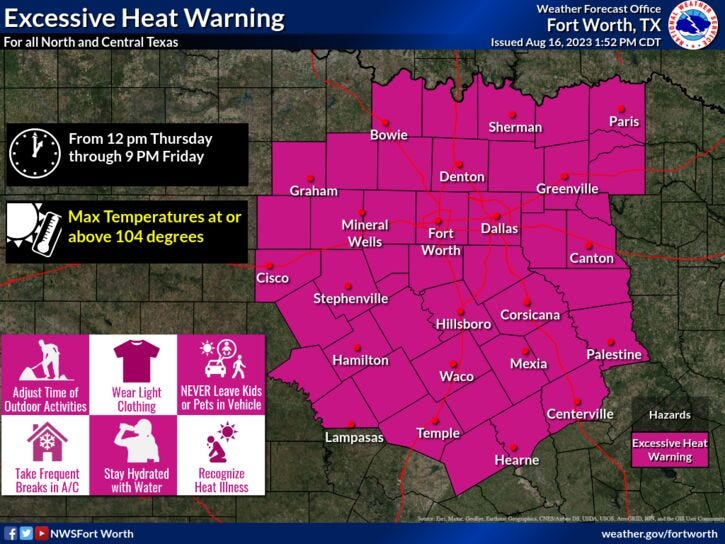
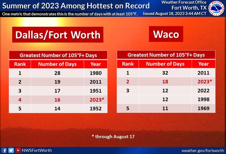
Of course, as we all know the big story is the record-breaking heat across North Texas. Yesterday we topped out at 109°, breaking the old record from 1951 when we hit 107°. More records will be broken across North Texas over the next 7 days.
One of the strongest upper level high pressure areas in decades is gripping, not just north Texas but the entire state. It also stretches into the central plains states into the mid Mississippi River Valley. Records will be broken in all of these areas of the coming days. The record high at DFW today is 112°. I'm forecasting a high of 110°. We will come very close to tying this record.
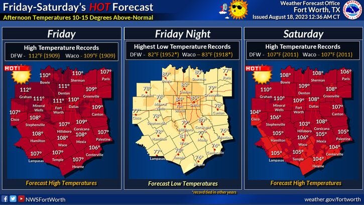
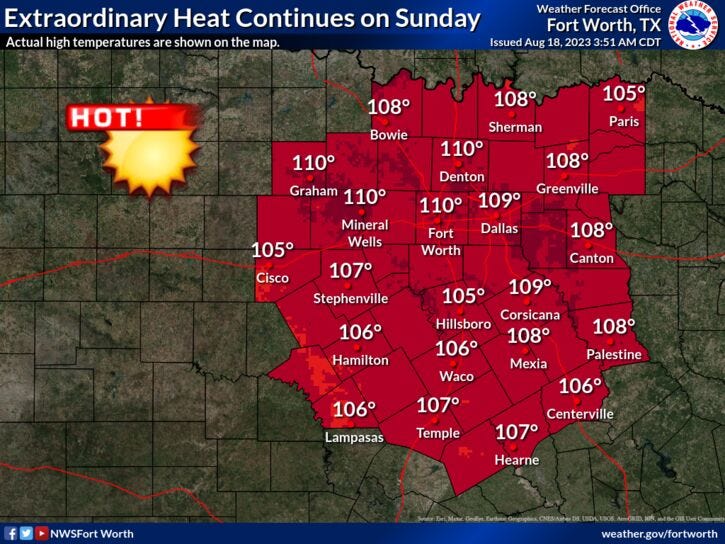
Unfortunately, records will be broken this weekend. The records for both days are 107°. I'm forecasting a high tomorrow of 109°. 111° on Sunday. The hottest temperature ever recorded in the month of August was 112°, again that's our record high for today.
The relentless heat will continue next week, but it will be a few degrees cooler. The record highs for Monday and Tuesday are 105°. I'm forecasting a high of 107° on Monday, 106° on Tuesday. Wednesday and Thursday will be equally as hot. 104° on Wednesday, 107° on Thursday. We may tie the record on Thursday. Excessive heat warnings will continue through the weekend and most likely into next week.
Extended data is showing temperatures cooling to near 100° the following weekend with maybe some rain around.
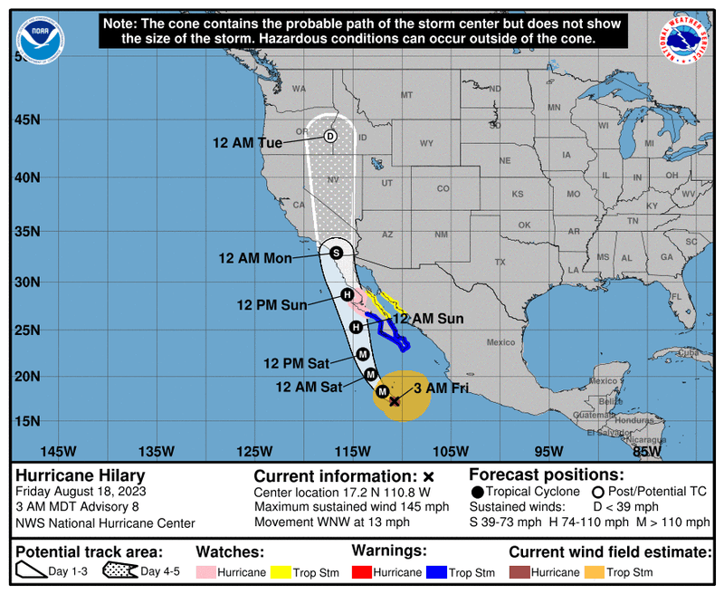
In other news, major Hurricane Hillary continues to turn about 600 miles southwest of Cabo San Lucas and southern Baja California. Wind as of 5:00 a.m. this morning was at 145 mph as it continues to move NNW at 12 miles per hour. This storm will miss Cabo, but increased wave height, storm surge and some rain will be the threats. Hillary will continue to move NNW and will make landfall across the northern parts of west central Baja early Sunday. It will continue to move north and head towards San Diego by early Monday morning producing tropical storm force wind. Only four storms since the mid 1800s have produced tropical storm force wind in southern California. Only one hurricane has made landfall and that was way back in 1858. Widespread flash flood watches are in place across the Desert Southwest next week where 6 to 12 inches of rain will fall, with higher totals in the mountainous terrain. This storm will make national news, with major flooding taking place in areas that don't see much rain during the year.
A quick update on the rest of the tropics. The Gulf of Mexico is quiet, in the western Atlantic, there is an area of disturbed weather around the Turks and Caicos Islands. This is forecast to move into the Gulf of Mexico this weekend and bring some welcome rain to areas of south Texas, mainly south of Interstate 10, starting late Monday through Wednesday. A few showers could sneak close to DFW, but it looks doubtful right now. There are three more areas of disturbed weather in the far eastern Atlantic. All of these need to be watched over the coming days and weeks. Peak hurricane season arrives in September.
*Yest Rain: 0.00"; Yest High: 109R; Low: 74
*Today’s Averages: High: 96; Low: 76
*Record high: 112 (1909): Record low: 65 (1992)
*August rain: Trace; Deficit: 1.03"
*2023 Rain: 14.83"; Deficit: 8.57"
*Sunrise: 6:53am; Sunset: 8:10pm
Today: *Excessive Heat Warning; Air Quality Alert* Sunny and hot. Near record heat. High: 110 (Record is 112). Wind: SSE 5-10 mph.
Tonight: Clear and warm. Low: 78-85. Wind: SSE 5-10 mph.
Saturday: *Excessive Heat Warning* Sunny and hot. Record heat. High: 109 (Record is 107). Wind: SSE 5-10 mph.
Sunday: *Excessive Heat Warning*. Sunny and very hot. Record heat. High: 111. (Record is 107).
Monday: *Excessive Heat Warnings likely* Sunny and hot! Record heat. High: 107 (Record is 105).
Tuesday: *Excessive Heat Warning likely* Sunny and hot! Near record heat. High: 106 (Record is 105).
Wednesday: Sunny and continued hot. High: 104 (Record is 107).
Thursday: Sunny and hot. Near record heat. High: 107 (Record is 106).
Related

LISTEN on the Audacy App
Tell your Smart Speaker to "PLAY 1080 KRLD"
Sign Up to receive our KRLD Insider Newsletter for more news