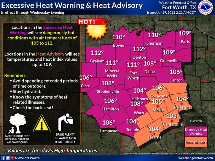

Excessive Heat Warnings, record breaking heat, high grass fire danger, a brief cool-down, a few scattered showers and storms, and then more heat. Those are your weather stories across north Texas over the next 7 days.
We're starting off this morning in the low to mid-80s, just like we did yesterday. Unfortunately, this means we'll be back near 109° today, like we felt yesterday. We didn't break a record yesterday, but our records today and tomorrow are 108° at DFW Airport. We're going to come close to tying or breaking records each day.
If there's any good news out of this, we won't be dealing with heat index values, because the air will be so dry at the surface. Speaking of the word dry, no measurable rain has fallen at DFW airport for 45 days now. Unfortunately, we'll add two more days to that before a subtle weather change arrives into Thursday and Friday. Slightly cooler temperatures are on the way!
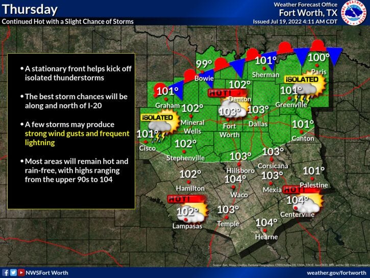
A cold front will slide into Oklahoma tomorrow, producing scattered showers and storms to our north. These storms will stretch farther west and southwest affecting parts of the Panhandle and the northwestern Red River Valley. A few of these storms could sneak into our northwestern counties by Wednesday evening, before dying out around midnight. As this front gets closer, and leftover cool boundaries work across north Texas on Thursday, there is a chance of scattered showers and storms, but chances are only at about 30%. Gusty wind, dangerous lightning, and heavy downpours are the threats.
With the clouds and higher humidity around both days, temperatures will only be in the upper 90s, but cool rapidly if you see rain in your backyard. Rainfall chances on Friday are only at about 10%, as high pressure slowly builds back into the area. This means more triple digit heat is on the way, but not as hot as we've been experiencing yesterday and over the next couple of days.
I'm forecasting highs between 101° and 104° through early next week.
*Yest Rain: 0.00”; *Yest High: 109; Low: 86
*Today’s Averages: High: 96; Low: 76
*Record high: 108 (2018); Record low: 68 (1917. 1990, 2014)
*July rain: 0.00”; July deficit: 1.46"
*2022 Rain: 12.41”; 2021 deficit: 9.34"
*Sunrise: 6.33am; Sunset: 8:35pm
Today: *Excessive Heat Warning* Sunny, breezy, and VERY hot. High: 108-110 (Record 108). Wind: SSW 15-20 mph.
Tonight: Clear and warm. Low: Low to mid 80s. Wind: SSW 10-20 mph.
Tomorrow: *Excessive Heat Warning* Sunny, breezy and VERY hot. Slight chance of showers and storms by evening (NW of DFW). High: 108-110 (Record 108). Wind: SSW 10-20 mph.
Thursday: Partly to mostly cloudy and a bit cooler. A slight chance of showers and storms. High: Upper 90s.
Friday: Mostly sunny and hot. High: 102.
Weekend: Sunny and hot. HIghs: 102-104.
Monday: More of the same. Sunny and hot. High: 103.
Related

LISTEN on the Audacy App
Sign Up and Follow NewsRadio 1080 KRLD