
More heat, Heat Advisories, a couple of cold fronts, and slight rain chances. Those are our weather stories across north Texas over the next 7 days!
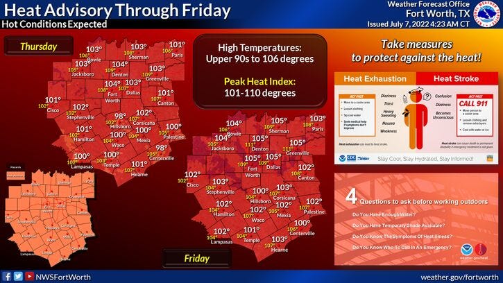
We'll have to wait a few more days for the first cold front. In the meantime, Heat Advisories remain in effect for today and tomorrow and will be extended into the weekend.
UPDATE- 7/7 3:30 p.m.: Excessive heat warning now in effect through Sunday.
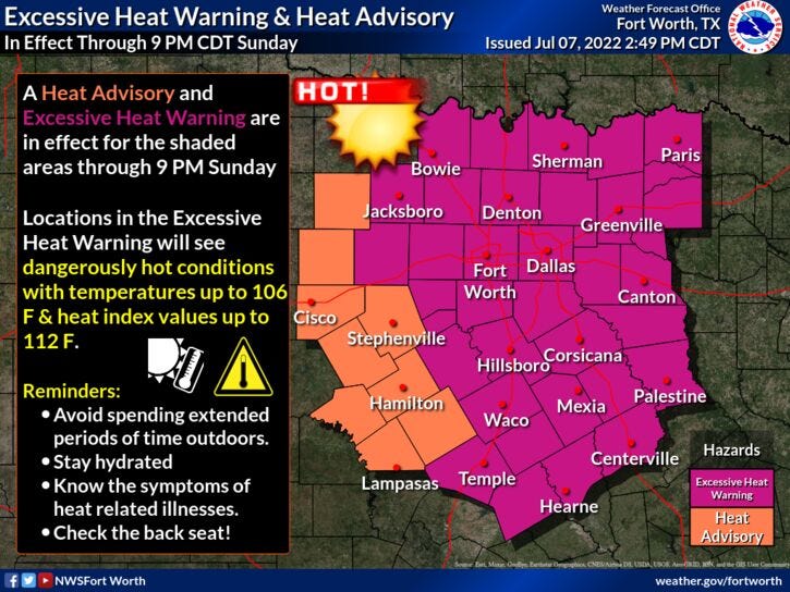
We're starting off this morning in the 80s again and we'll warm rapidly to around 103° this afternoon. Humidity won't be too bad, so the heat index value will barely be above 105°. Still hot, but tolerable. More of the same for tomorrow and most likely a degree higher with readings close to 104°. I think Saturday will be our hottest day over the next 7 days with highs approaching 105° to 106° degrees. A little more humidity around will push that heat index to near 108°. A weak cold front will settle into the area by late evening into early Sunday morning bringing a very slight chance for a shower storm with it. Best chances will be along the Red River into Oklahoma.
Sunday looks to be a couple degrees cooler with a high around 103°. We're back around 105° on Monday with plenty of sunshine.
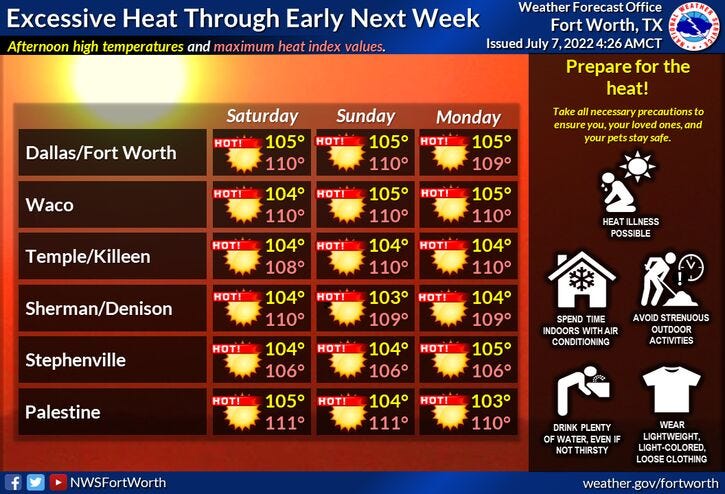
By Tuesday evening, another stronger front will back in from the NE. There is a slight chance for a storm to develop but a bit better chance across the area on Wednesday, but only in about 30%. Afternoon highs on Monday will be around 104°, 102° on Tuesday, but only in the mid to upper 90s by Wednesday! Briefly. I say this because high pressure will build back into the area by the end of next week and into the following weekend, as triple digit heat will build back across the area. It's July in Texas.
*Yest Rain: 0.00”; *Yest High: 102; Low: 82
*Today’s Averages: High: 95; Low: 75
*Record high: 106 (1996); Record low: 64 (1968, 1972)
* July rain: 0.00”; July deficit: 0.60"
*2022 rain: 12.41”; 2022 deficit: 8.48"
*Sunrise: 6:26am; Sunset: 8:40pm
Today: *Heat Advisory* Sunny and hot. High: 99-103. Heat index 105. Wind: SSW 10-20 mph.
Tonight: Clear and warm. Low: Low 80s. Wind: South 10-20 mph.
Tomorrow: *Heat Advisory* Sunny and hot. Less wind. High: 104. Heat index 106. Wind: SSW 5-10 mph.
Saturday: Partly cloudy, continued hot. Slight chance of a late day storm. Highs: 102-106.
Sunday: Partly cloudy and hot. Highs: 101-104.
Monday: Sunny and hot. Highs: 102-104.
Tuesday: Partly cloudy and continued hot. Slight chance of showers and storms late. High: 99-101.
Wednesday: Partly cloudy. Not as hot. Slight chance of showers and storms. Cooler. High: Mid to upper 90s.
Related

LISTEN on the Audacy App
Sign Up and Follow NewsRadio 1080 KRLD