
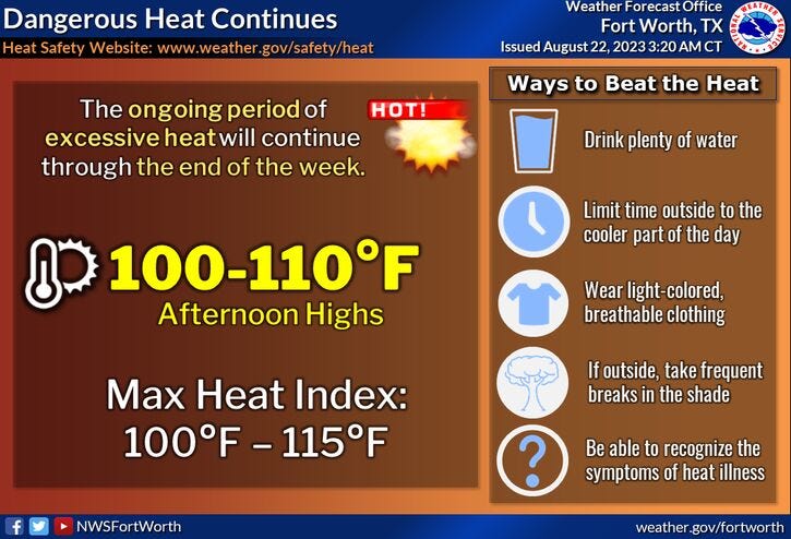
We set a record high again yesterday when we reached 106°. We'll come close to tying the record of 105° today.
This ridge of high pressure has weakened a little bit over north Texas but will move back towards us Thursday through Sunday with record-breaking heat returning to the area. Excessive Heat Warnings will return as well. Afternoon highs will range between 107 and 109° Thursday through Sunday tying or breaking records each day.
There is a slight chance of some showers and storms Sunday and Monday as a week front settles into the area. Monday's high may only reach 102°. Temperatures may drop below 100° after that through the middle of next week.
Shifting gears to the tropics, Tropical Storm Harold formed overnight. Wind as of 4:00 a.m. is at 45 mph and is ~50 miles ESE of Port Mansfield. A bit more strengthening may occur over the next 6 hours, before it makes landfall after the noon hour between Corpus Christi and Brownsville.
Tropical storm warnings are in effect along the lower Texas coast today, where two to five inches of rain will fall over the next 24 hours. Dangerous rip currents and coastal flooding are the threats. Not a good beach day.
This system will continue to weaken quickly as it moves west into the mountains of northern Mexico late this evening. Harold will then curve northbound and move close to El Paso late tomorrow and into Thursday bringing heavy rain to west Texas. Flash flood watches are in effect for these areas.
41 triple digit days so far this year, 21 105° plus days as well. Hang in there ... we'll slowly creep below 100° by the beginning to middle of next week. Fall is 32 days away.
*Yest Rain: 0.00"; Yest High: 106R; Low: 82
*Today’s Averages: High: 95; Low: 75
*Record high: 105 (1980, 2010): Record low: 61 (1956)
*August rain: Trace; Deficit: 1.33
*2023 Rain: 14.83"; Deficit: 8.87
*Sunrise: 6:56am; Sunset: 8:06pm
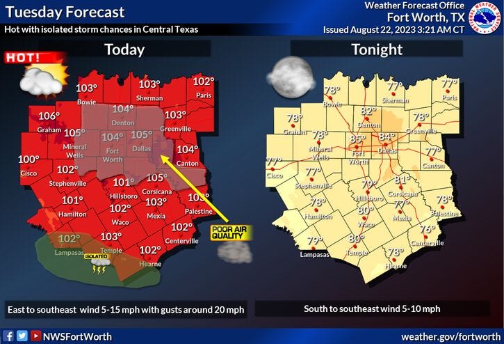
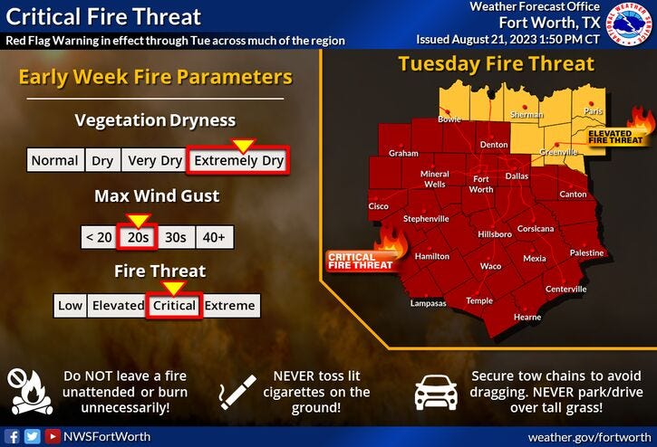
Today: *Excessive Heat and Red Flag Warnings; Air Quality Alert* Partly cloudy, breezy and hot. Grass fire danger. Near record heat. High: 105 (Record is 105). Wind: ESE 10-20.
Tonight: Partly cloudy and warm. Low: 78-85. Wind: South 5-10 mph.
Wednesday: Mostly sunny and hot. High: 104 (Record is 107). Wind: East 10-20 mph.
Thursday: *Possible Heat Warnings* Sunny and hot. Near record heat. High: 107 (Record is 106).
Friday: *Possible Heat Warnings* Sunny and very hot. Record heat. High: 109 (Record is 106).
Saturday: *Possible Heat Warnings* Sunny and very hot. Record heat. High: 109 (Record is 106).
Sunday: Partly cloudy, continued hot. Slight chance of rain late. Near record heat. High: 107 (Record is 107).
Monday: Partly cloudy, a bit cooler. Slight chance of rain. High: 102.
Related

LISTEN on the Audacy App
Tell your Smart Speaker to "PLAY 1080 KRLD"
Sign Up to receive our KRLD Insider Newsletter for more news