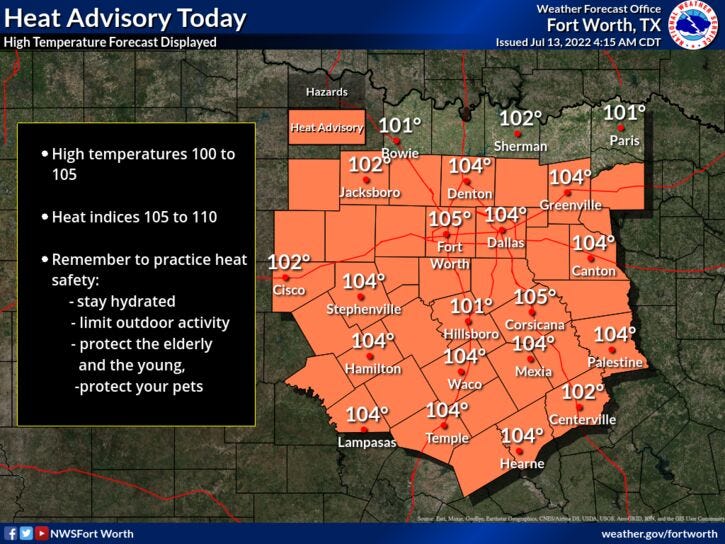

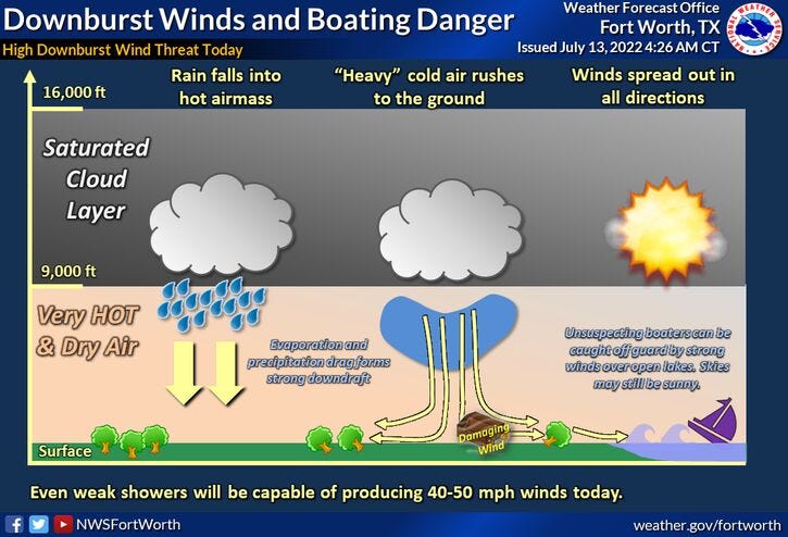
A Heat Advisory has been extended to run until 9 p.m. on Thursday, while there's also a very slight chance for a late afternoon and early evening shower storm today and tomorrow, after that we dry out through the weekend.
We're starting off this morning in the mid 70s to low 80s with not a cloud in the sky. Another Heat Advisory and Air Quality Alert is in effect for today with afternoon highs around 103°.
Again, there's a very slight chance for a late afternoon and early evening storm, but most will stay dry. Gusty wind will be the threat if you do see one in your neighborhood.
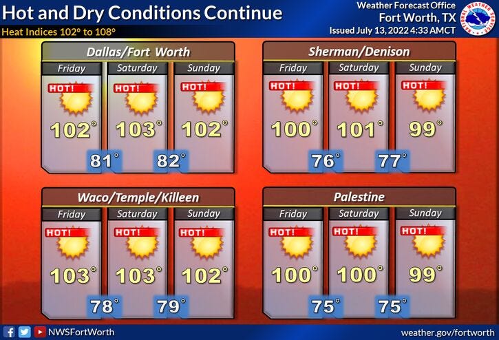
Unfortunately, we'll most likely have several more Heat Advisories over the next 6 days, with daytime highs between 102° and 104°. I'll mention again, there's a slight chance for a late afternoon and early evening shower storm tomorrow and then again next Monday.
By the way, today will be the 20th triple-digit temperature this year. That is right at average. Unfortunately, we have at least six more triple-digit temperatures to come through next Tuesday.
* Yest Rain: 0.00”; *Yest High: 102; Low: 80
* Today’s Averages: High: 95; Low: 76
* Record high: 107 (1980); Record low: 64 (1990)
* July rain: 0.00”; July deficit: 1.07"
* 2022 rain: 12.41”; 2022 deficit: 8.95"
* Sunrise: 6:30am; Sunset: 8:38pm
Today: *Heat Advisory and Air Quality Alert* Mostly sunny and hot. Slight chance for storms (4pm-9pm). High: 103. Heat index 106. Wind: NE 5-10 mph.
Tonight: Clear, warm and muggy. Low: 78-82. Wind: ESE 5-10 mph.
Tomorrow: *Heat Advisory until 9 p.m.* Mostly sunny and hot. Slight chance of showers and storms. High: 102. Wind: ESE 10-20 mph.
Friday - Sunday: Mostly sunny and hot. Highs: 101-103.
Monday: Partly cloudy and hot. Slight chance for afternoon and early evening storms. High: 102.
Tuesday: Mostly sunny, continued hot. High: 102.
Related

LISTEN on the Audacy App
Sign Up and Follow NewsRadio 1080 KRLD