
We ONLY hit 103° yesterday and did not break a record. Unfortunately, the heat will build back across the area today and especially Thursday, Friday, and Saturday.
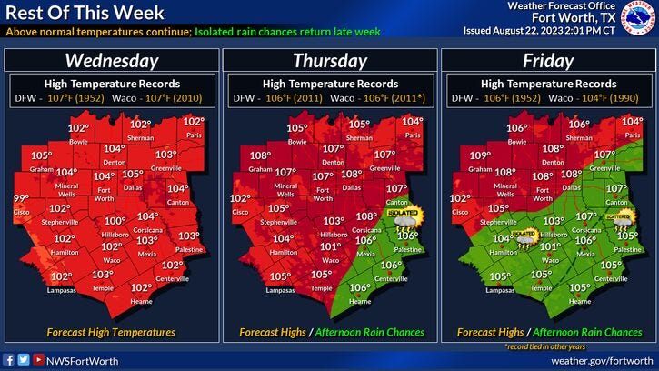
The upper level ridge of high pressure that has drifted a little bit farther away from north Texas will return soon, bringing record high temperatures back to the area. 104° today was a Heat Advisory. Heat index values will approach 110 degrees. 106 on Thursday, 108 on Friday and Saturday. We'll most likely break record highs.
By Sunday, a slow moving cold front will be crossing the Red River Valley, bringing a chance for some scattered showers and storms to north Texas. We'll still be hot with a high near 105.
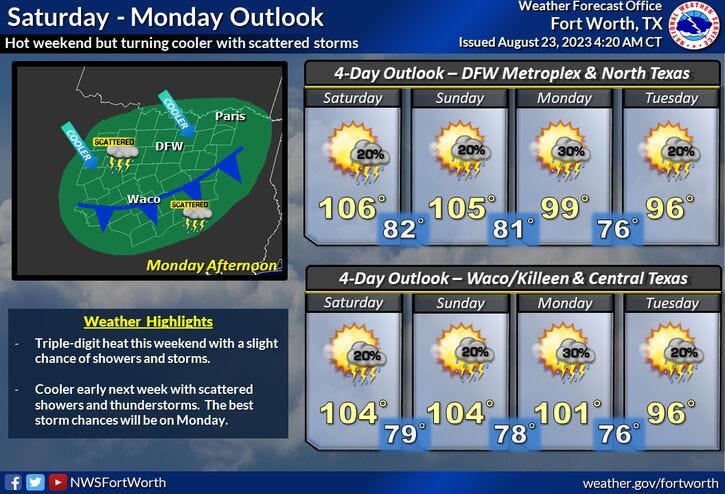
This weak front will settle just south of DFW on Monday with high temperatures ONLY in the upper 90s. A few scattered storms may develop during peaking hours. Upper 90s again for Tuesday with a few leftover late day showers and storms, especially south of DFW..
Fall is 31 days away. Hang in there, we'll cool off eventually.
*Yest Rain: 0.00"; Yest High: 103; Low: 82
*Today’s Averages: High: 95; Low: 75
*Record high: 1057(1952, 2010): Record low: 64 (1949, 1956, 1961)
*August rain: Trace; Deficit: 1.40
*2023 Rain: 14.83"; Deficit: 8.94
*Sunrise: 6:57am; Sunset: 8:04pm
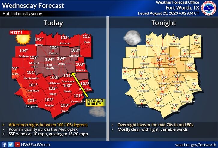
Today: *Heat Advisories and an Air Quality Alert* Mostly sunny, hot and humid. High: 104 (Record is 107). Heat index new 110. Wind: South 5-10 mph.
Tonight: Clear and warm. Low: 78-83. Wind: South 5-10 mph.
Thursday: * Possible Heat Warnings* Mostly sunny and hot. High: 106 (Record is 106. Wind: South 5-10 mph.
Friday: *Possible Heat Warnings* Sunny and very hot. Record heat. High: 108 (Record is 106).
Saturday: *Possible Heat Warnings* Sunny and very hot. Slight chance of rain by evening. Record heat. High: 108 (Record is 106).
Sunday: Partly cloudy, continued hot. Cold front approaches by evening. Slight chance of rain late. High: 105.
Monday and Tuesday: Partly cloudy, a bit cooler. Slight chance of rain. High: Upper 90s.
Related

LISTEN on the Audacy App
Tell your Smart Speaker to "PLAY 1080 KRLD"
Sign Up to receive our KRLD Insider Newsletter for more news
Follow us on Facebook | Twitter | Instagram | YouTube