
LIVE WEATHER RADAR ABOVE, COURTESY OF OUR MEDIA PARTNERS AT NBCDFW
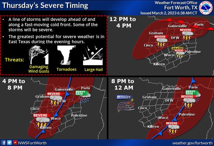
A Tornado Watch is in effect for parts of North Texas until 10 p.m. Thursday while Severe Thunderstorms are expected across all of North Texas.
The National Weather Service Storm Prediction Center lists a "Moderate" risk for severe weather, including winds up to 75 mph, hail as large as 3 inches, and a few tornadoes Thursday evening.
It will be windy and cooler overnight Thursday with leftover showers. Rapid clearing will follow Friday, with a breezy and cool weekend ahead. Temperatures will be near 80 on Monday and Tuesday. Our next rain chance arrives late Tuesday into Wednesday.
A cold front stalled south of North Texas Thursday morning. North of the front, temperatures were in the 50s, south of the front, readings were near 70 degrees. The front slowly lifted to the north late in the morning, sparking scattered thunderstorms. By 5 p.m., a line of severe storms will develop to the west of Fort Worth.
Please make sure you have a safety plan in place, that you get your weather information from a reliable source and have multiple ways of receiving warnings and make sure your cellphones are fully charged. Also, If you have any power banks laying around, make sure they're fully charged as well.
After midnight, the upper-level low will pass through the area, sparking some cold rain, especially along and north of I-20. The rain and clouds will exit rapidly to the east by mid-morning. Plus, the wind overnight will gust as high as 55 mph from the west, as temperatures fall into the low to mid 40s. Morning clouds afternoon sun tomorrow with highs in the low 60s.
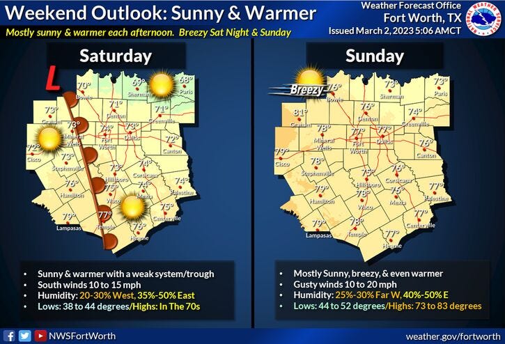
The weekend looks nice with plenty of sunshine. Highs will warm into the low seventies on Saturday, mid to upper seventies on Sunday.
Monday's weather will be just as nice and a bit warmer. Afternoon highs will reach the low eighties. Our next rain chance arrives late Tuesday into Wednesday. Tuesday's highs will be in the upper seventies, cooling into the low sixties on Wednesday.
Please stay weather aware this afternoon and evening and please listen to KRLD throughout the day as conditions start to deteriorate.
Stream 1080 KRLD on your mobile device - on the Audacy app

*Yest Rain: 0.04"; Yest High: 71; Low: 64
*Today’s Averages: High: 64; Low: 44
*Record high: 90 (1901); Record low: 15 (1980)
*March Rain: 0.04"; Deficit: 0.07"
*2023 Rain: 5.39"; Deficit: 0.01"
*Sunrise: 6:55am; Sunset: 6:26pm
Thursday: Mostly cloudy, windy and warm. Afternoon and evening severe storms. Threat levels 3 and 4 out of 5. Timing: 2pm-10pm from west to east. Tornado timing: 3pm-7pm; Storm Threats: Large hail, damaging wind, isolated tornadoes. High: Mid to upper 70s. Wind: SE 15-25, G30 mph.
Thursday night: Evening severe storms, then a chance of showers after midnight. Turning VERY windy and MUCH colder. Low: Low to mid 40s. Wind: West 25-35, G55 mph.
Friday: Sunny, VERY windy through late morning. Cooler. High: Near 60. Wind: WNW 20-30, G50 mph.
Saturday: Sunny and pleasant. High: Near 70.
Sunday: Sunny, breezy and a bit warmer. High: Mid to upper 70s.
Monday: Mostly sunny and warm. High: Near 80.
Tuesday: Mostly cloudy and mild. Chance of showers. High: Upper 70s.
Wednesday: Mostly cloudy and cooler. Chance of showers. High: Low 60s.
Related

LISTEN on the Audacy App
Tell your Smart Speaker to "PLAY 1080 KRLD"
Sign Up to receive our KRLD Insider Newsletter for more news