
UPDATE: 11:10 P.M.
The National Weather Service has issued a Tornado Warning for Waxahachie, Midlothian and Red Oak until 11:45 p.m.
UPDATE: 11:00 P.M.
The National Weather Service has issued a Severe Thunderstorm Warning that includes Mansfield, DeSoto and Cedar Hill until 11:45 p.m.
UPDATE: 10:43 P.M.
The National Weather Service has issued a Severe Thunderstorm Warning that includes Dallas, Garland and Mesquite until 11:30 p.m
LISTEN TO 1080 KRLD FOR LATEST NEWS, WEATHER & TRAFFIC.

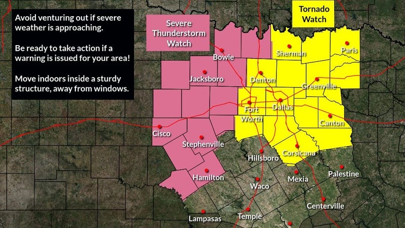
The National Weather Service has placed the Dallas-Fort Worth area of "enhanced" risk for severe weather Monday night.
The critical time for a big line of storms that plow through North Texas will be from 10 p.m. Monday to 1 a.m. Tuesday. Small hail, damaging winds, and isolated tornadoes are possible along the leading edge of this squall line.
In the meantime, North Texas is waking up to a blue sky, but clouds are rapidly moving in from the south. It will become cloudy through Monday morning into the early afternoon. Some breaks in the clouds are possible later Monday, with highs in the mid-70s -- cooler than Sunday due to the cloud cover.
Storms will break out to the west of Dallas and Fort Worth late this afternoon through mid-evening. This is where the larger hail and isolated stronger tornadoes are possible, especially west of U.S. Route 281, which runs from Wichita Falls to Mineral Wells towards Lampasas. This line will become linear after 9 p.m. and plow through the area toward midnight. Please make sure you stay weather aware again between 10 p.m. and 1 a.m. from west to east across Dallas and Fort Worth.
North Texas will also get some welcome rain out of this event, with one to two inches possible.
The skies will clear out by Tuesday morning, as the dryline punches through. It will be very warm Tuesday with highs well up into the 80s.
Two cold fronts will affect North Texas on Wednesday, and then again on Thursday -- unfortunately, they'll come through dry.
Highs will be in the 60s Wednesday through Friday, with morning lows Thursday and Friday dipping into the 30s away from town with low 40s in the immediate Dallas-Fort Worth area. Make sure you protect your plants and cover your gardens for Thursday and Friday morning.
By the weekend, temperatures will warm up into the 70s on Saturday and 80s on Sunday.
The next rain chance will arrive late Sunday and into Monday.
Download the Audacy app to listen to KRLD 24/7 anytime, anywhere.
_______________________________________________________
7-Day Headlines:
* High Sunday: 86 degrees at DFW.
* Severe storms Monday evening. Level 3 out of 5.
* THREATS: Hail, wind, isolated tornadoes, street flooding.
* Timeline: 7 p.m. - 1 a.m. from west to east.
* A VERY warm Tuesday.
* Strong cold front early Wednesday.
* A cooler and windy end to the week.
_________________________________________________________
*Sunday Rain: 0.00”; *Sunday High: 86; Low: 54
*Monday’s Averages: High: 74; Low: 52
*Record high: 94 (1940); Record low: 31 (1920)
_________________________________________________________
* April rain: 0.02”; April deficit:
*2022 Rain: 4.25”; 2022 deficit
*Sunrise: 7:12 am; Sunset: 7:51pm
Monday: Morning clouds, peeks of afternoon sunshine. Storms breaking out to our west after 3 p.m. High: Mid 70s. Wind: SE 10-20, G25 mph
Monday night: Severe storms possible. LeveI 3 out of 5 (Enhanced Risk). Threats: Hail, wind and Isolated tornadoes. Time: 7 p.m. - midnight. Rain totals: 1-2”. Low: Low to mid 50s. Wind: Shifting WNW 10-20 mph.
Tuesday: Mostly sunny, breezy and warm. High: Mid to upper 80s. Wind: SW 10-20 mph.
Wednesday: Sunny, windy and cooler. High: Upper 60s.
Thursday. Protect plants in the morning. Sunny and very windy and cool. High: Mid 60s.
Friday: Protect plants in the morning. Sunny, less wind and continued cool. High: Upper 60s.
Saturday: Sunny and perfect. High: Upper 70s.
Sunday: Mostly sunny. Our warm up continues. High: Low 80s.
Related

LISTEN on the Audacy App
Sign Up and Follow NewsRadio 1080 KRLD