
Live radar in the above video player is courtesy of KRLD's media partner NBC 5.
A Tornado Watch is in effect for most of North Texas until 8 p.m. Friday. The National Weather Service issued a Severe Thunderstorm Warning for areas including Mesquite, McKinney & Rowlett until 6:30 p.m. A Tornado Warning has been issued for areas including Rockwall, Greenville & Royse City until 6 p.m.
Tornado threat increasing just east of Dallas
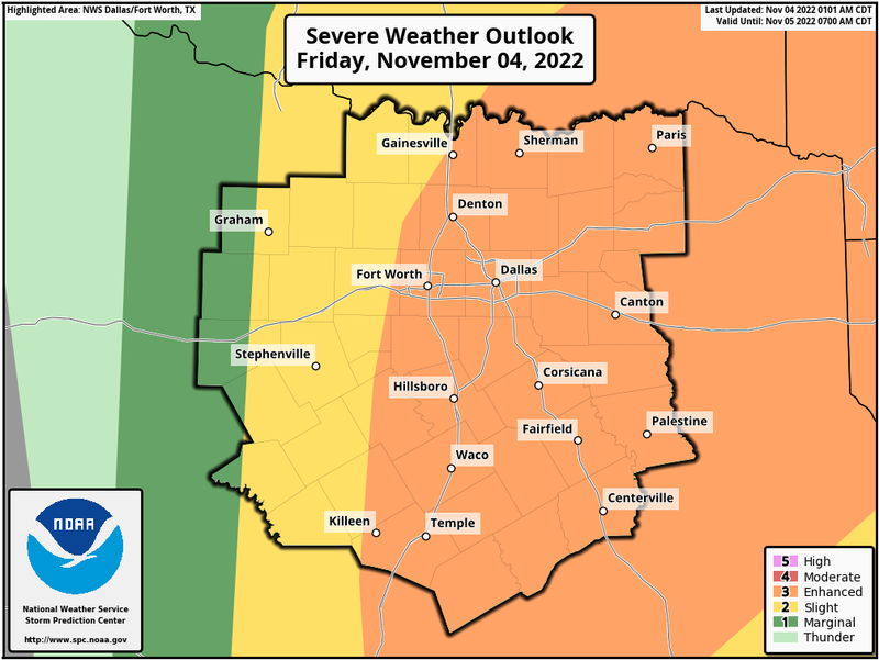
A level four out of five for severe weather is in place east of Dallas (in red shading). If you live in these areas, or if you have family and friends that live in these areas, please stay weather aware between 3 p.m. and 9 p.m. The window for severe weather in Dallas-Fort Worth is between 2 p.m. and 7 p.m. The tornado threat is much lower from DFW Airport and points west.
There will be two waves of strong to isolated severe storms to deal with. The first wave developed rapidly after 12 p.m., mainly along and east of Highway 281. These are the storms we need to watch for the largest hail, damaging wind, and an isolated tornado or two. These will rapidly move to the northeast. I do want to stress, not everyone will see severe storms with the first wave.
The second wave of storms will develop along a cold front that'll move through North Texas from west to east between 4 p.m. and 7 p.m. This will be a broken line of storms right along I-35W and rapidly congeal into a strong line of showers and storms as it presses east toward McKinney, Dallas, and Waxahachie. These storms will become more intense as they press just east of Dallas into East Texas. Damaging wind, small hail, and an isolated tornado will be the threats with this squall line.
After 7 p.m., the storms will be out of the Dallas-Fort Worth area and rock residents across East Texas. Damaging wind and an isolated tornado or two will continue to be the threats, as this line intensifies and moves into the Piney Woods of East Texas.
So in a nutshell, stay weather aware across North Texas between 1 p.m. to 7 p.m., from Weatherford to Rockwall, with two waves of storms. As soon as your wind turns northwesterly and you feel a rush of cool air, your storm threat is done. This will occur from west to east between 6 p.m. and 8 p.m. After that, clouds will rapidly decrease, and it will turn windy and much cooler.
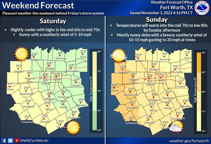
Saturday morning, you'll wake up to sunshine and chilly temperatures. Lows will drop into the mid to upper 40s. Sunshine and breezy conditions will dominate tomorrow with highs in the upper 60s. Sunday looks nice as well with a quick warm up. Morning lows will drop into the 50s, with afternoon highs warming into the mid to upper 70s.
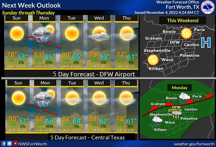
By Monday, there's a chance for a few scattered showers across the area streaming in from the south. These will be non-severe and a lot of you won't see a drop. Tuesday through Thursday look nice, but humid. Morning low clouds, afternoon sunshine with unseasonably warm temperatures will be felt. Afternoon highs will reach near 80°. Our next system looks to arrive late Thursday into Friday bringing another slight chance of rain and cooler temperatures into the weekend.
*Yest Rain: 0.00"; High: 80; Low: 66
*Today’s Averages: High: 71; Low: 50
*Record high: 90 (2017); Record low: 25 (1991)
*November rain: Trace; Deficit: 0.34"
*2022 Rain: 27.85”; 2022 deficit: 4.13"
*Sunrise: 7:49am; Sunset: 6:34pm
Today: Mostly cloudy and warm. Afternoon and early evening storms, some severe. Threats: Damaging wind, hail, isolated tornadoes between 1pm and 7pm. **The worst of it will be east of Central Express. and I-45** High: Mid to upper 70s. Wind: SSE 15-25, G30 mph.
Tonight: Early evening strong to severe storms, east of DFW, then decreasing clouds, windy and MUCH cooler. Low: Mid to upper. Wind: NW 20-30, G35 mph.
Saturday: Sunny, breezy and cooler. High: Mid to upper 60s. WInd: NW 15-25 mph.
Sunday: Mostly sunny, windy and warmer. High: Mid to upper 70s.
Monday: Partly to mostly cloudy. Isolated showers. High: Near 80.
Tuesday - Thursday: Mostly sunny and unseasonably warm. Highs: Near 80.
Related

LISTEN on the Audacy App
Tell your Smart Speaker to "PLAY 1080 KRLD"
Sign Up and Follow NewsRadio 1080 KRLD