
Welcome to another Tuesday! Above average temperatures, a couple of cold fronts, and the possibility of some rain finally returning to the area by late weekend. Those are our weather stories over the next 7 days.
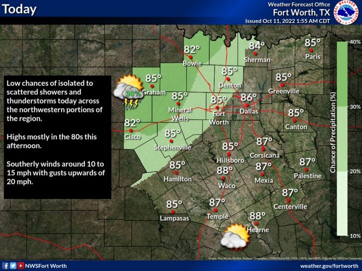
Not a lot going on this morning across north Texas. There will be a few scattered showers developing and cruising across the area through noon today. Unfortunately, most will stay dry. Temperatures are starting off in the low 60s to near 70°, with some cloud cover overhead in areas.
Sunny and warm today with highs back in the mid 80s. A south wind will blow 15 to 25 mph. It's been a while since we've had a breezy day. It'll feel nice!
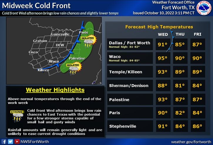
A fair sky will prevail tonight, with lows only in the mid to upper 60s. Tomorrow looks to be partly cloudy, as a cold front comes through after the noon hour. There's a very slight chance of showers and storms mainly east and northeast of DFW. I don't think we see a drop here. Afternoon highs still may reach 90°, especially south of DFW, before cooling into the 60s by evening.
After a cool start Thursday morning, temperatures will be a little cooler in the afternoon as well. Forecasting highs in the low 80s. Unfortunately, this cold front lifts back to the north on Friday. Afternoon highs back will warm into upper 80s. Near 90 for Saturday! By Saturday evening, clouds will rapidly increase and there is a chance for scattered showers and storms by midnight as a stronger cold front comes into the area. This will drop temperatures from the mid 70s on Sunday morning down through the 60s during the day, with a pretty decent shot of showers and storms. I'll keep you posted on precipitation coverage as we get closer to this weather change.
By Monday, there is still a chance for some scattered showers around, with high temperatures ONLY in the mid 60s! That's more like it!
Have a wonderful day today and enjoy the weather when you can, it's the only weather you've got!
7-Day Headlines:
* DFW reached 87 degrees yesterday... 0.00" of rain.
* A few showers this morning.
* Above average temperatures through Saturday.
* Weak cold front tomorrow.
* A bit cooler Thursday.
* Warming Friday and Saturday.
* Rain and cooler temps Sunday int Monday.
*Yest Rain: 0.00"; High: 87; Low: 65
*Today’s Averages: High: 81; Low: 59
*Record high: 99 (1977); Record low: 42 (1905, 1932, 1970)
*October rain: 0.00"; October deficit:
*2022 Rain: 23.42”; 2022 deficit:
*Sunrise: 7:29am; Sunset: 7:00pm

Looking Ahead:
Today: Morning clouds and showers, afternoon showers. Warm and windy. High: Mid 80s. Wind: South 15-25 mph.
Tonight: Mostly clear and mild. Low: Mid to upper 60s. Wind: South 10-20 mph.
Tomorrow: Partly cloudy, breezy and hot. Turning cooler by mid afternoon. DRY cold front. High: Near 90. Wind: Shifting NW 10-20 mph.
Thursday: Mostly sunny and a tad cooler. High: Low 80s.
Friday: Mostly sunny and warm. Highs: Upper 80s.
Saturday: Increasing clouds by evening. Chance of showers and storms by midnight. High: Near 90.
Sunday: Cloudy, breezy and cooler. Chance of showers and storms. High: Low 70s early, falling through the 60s by afternoon.
Monday: Cloudy and cool. Scattered showers. High: Mid 60s!!!
Related

LISTEN on the Audacy App
Sign Up and Follow NewsRadio 1080 KRLD