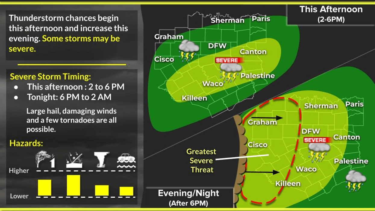
Severe weather threat returns to North Texas later this afternoon, overnight tonight, and again during the first part of tomorrow. All modes of severe weather are possible, but not everyone will experience severe weather.
Good morning, and welcome to Tuesday. We are waking up to mild temperatures for this time of year, with readings in the upper 60s to low 70s and low clouds moving in from the Gulf. Clouds will be slow to clear through the morning, but we will see some sunshine this afternoon, with afternoon highs reaching the upper 70s.
A very strong upper-level low-pressure system will move across northern Mexico today and slowly creep into South Texas before weakening as it heads into Louisiana late tomorrow afternoon. This upper-level low will ignite the first round of strong to severe storms later this afternoon through this evening, mainly between 4:00 p.m. and 7:00 p.m. in areas southwest and south of DFW. All modes of severe weather are possible in these areas.
Our saving grace will be a strong cap, or lid, on the atmosphere that will grip our area through the day today and into early evening, keeping severe weather out of much of North Texas through the day. As we work our way through this evening, several clusters of storms will form to our west during the late afternoon, containing large hail, damaging wind, and isolated tornadoes. These clusters will congeal into a line of showers and storms a couple of hundred miles to our west. This line will be pretty intense west of the Dallas-Fort Worth area around 9:00 p.m. as it races east through 2:00 a.m. Wednesday morning.
Model data shows signs of this weakening as it comes into the DFW, especially mid-cities and points east, through the early morning hours. Small hail, damaging wind, and a brief spin-up tornado are possible. Moderate to heavy rain will continue after 3:00 a.m., lasting until mid to late morning on Wednesday. Most areas will pick up an inch or two of rain.
As we work past 10:00 a.m. Wednesday, this area of rain will intensify and become another very strong to severe line of storms as it moves into East Texas by late morning and afternoon. All modes of severe weather are possible in these areas, but our severe weather threat will be gone after 2:00 a.m. Wednesday.
A cold front will move into the area early Wednesday afternoon, slowly clearing things out by mid evening and drying the air toward Thursday morning. Afternoon highs tomorrow will reach the mid to upper 70s. We will wake up Thursday morning to a north wind gusting 30 mph and temperatures in the low to mid 40s. It will be very chilly when you wake up Thursday morning, a bit of a shock to the body again. Plenty of sunshine will dominate Thursday, with highs only in the mid to upper 60s as the wind relaxes through the day.
Warming temperatures are on the horizon Friday through the weekend as south winds return. After lows in the 40s Friday morning, afternoon highs will reach the upper 70s. Plenty of sunshine will dominate Saturday, with readings in the low to mid 80s, and low 70s on Sunday, before a very strong cold front plows into the area by noon. Winds will shift to the north and gust to 35 miles per hour, and temperatures will plummet into the 40s by bedtime. Wind chills will be in the 30s. Be sure to bring your pets indoors before you go to bed Sunday. You will wake up Monday morning to a breezy north wind gusting to 25 mph, with temperatures ranging from 28° to 33°. Wind chills will be in the 20s when you wake up. A week or so ago, I mentioned not to plant your gardens yet, and this is why.
Plenty of sunshine will dominate Monday, with breezy conditions and highs only in the low 50s. Temperatures will be close to freezing again on Tuesday morning, especially northeast of the Dallas-Fort Worth area. Temperatures will warm up by afternoon as southerly winds return. Afternoon highs will be near 60°. A warm-up will continue after that.
Have a great day today, please stay weather aware this evening, and try to enjoy the weather when you can, it's the only weather you've got.
7-Day Headlines:
* DFW Airport reached 85 yesterday.
* Strong LID or CAP is over north Texas through early evening.
* Isolated severe storms late this afternoon (west and south).
* Threats: Large hail, damaging wind, isolated tornadoes.
* Decaying line of storms moves in late this evening.
* Threats: smaller hail, damaging wind, isolated tornadoes.
* More storms east of DFW on Wednesday.
* Beautiful weather Thursday – Sunday. No rain.
*Yest Rain: 0.00"; Yest High: 85; Low: 46
*Today's Averages: High: 67; Low: 46
*Record high: 99 (1911); Record low 15 (1948)
*March rain: 1.70"; Surplus: 0.70"
*2026 Rain: 3.94"; Snow: 2.4" Deficit:
*Sunrise: 7:43am; Sunset: 7:33pm
Tuesday: A few morning showers. Scattered late afternoon severe storms, mainly west and SW of DFW (large hail, wind and isolated tornado). High: Near 80. Wind: South 15-25 mph.
Tuesday night: Cloudy, windy and wet. A decaying line of strong to severe storms (9pm-2am Wed). Worst of it remains west of I35W. Threats: Hail, damaging wind, brief spin up tornado. Low: Mid 60s. Wind: South 15-25 mph.
Wednesday: Morning showers and storms move east by noon. Severe storms develop to the east of DFW. Mostly cloudy, windy and cooler. High: Mid 70s, falling into the 60s during the day. Wind: South to north 10-20 mph.
Thursday: Sunny, less wind and PERFECT! High: Mid to upper 60s.
Friday: Sunny, warmer, continued nice. High: Mid to upper 70s.
Saturday: Sunny, windy and beautiful. High: Low 80s.
Sunday: Partly cloudy, turning windy and colder. High: Low 70s, falling temperatures into the 40s by evening.
Monday: Sunny and chilly. Low: Low to mid 30s; High: Near 50.
LISTEN on the Audacy App
Tell your Smart Speaker to "PLAY 1080 KRLD"
Sign Up to receive our KRLD Insider Newsletter for more news
Follow us on Facebook | Twitter | Instagram | YouTube