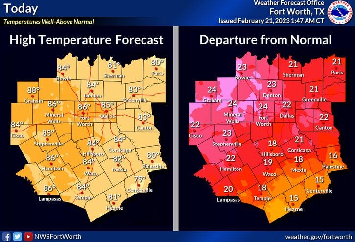

We're waking up the temperatures in the upper fifties to mid sixties this morning. Some areas are warmer than they should be on average during the afternoon hours. Mostly sunny today, breezy and very warm. High temperatures will reach the low to mid eighties.
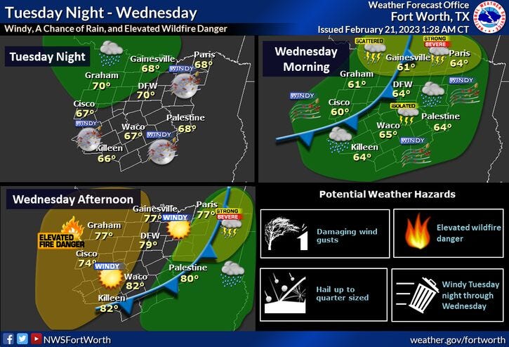
Tonight, increasing clouds with showers and a few rumbles of thunder moving into the area before daybreak.
On Wednesday, a few isolated severe storms are possible towards the Red River and east of Central Expressway. The rain will come to an end from west to east by lunchtime. Much drier air filters into north Texas behind the dry line. The wind will really increase (45mph gusts) around lunchtime.. Afternoon highs will reach the upper seventies.
The wind slowly relaxes overnight tomorrow into Thursday. Temperatures will be a bit cooler on Thursday with highs in the mid to upper sixties with plenty of sunshine..
Our next cold front arrives onThursday afternoon. Temperatures will tumble well down into the forties for Friday morning with increasing clouds. There is slight chance of showers on Friday, as afternoon highs struggle to get above 50゚.
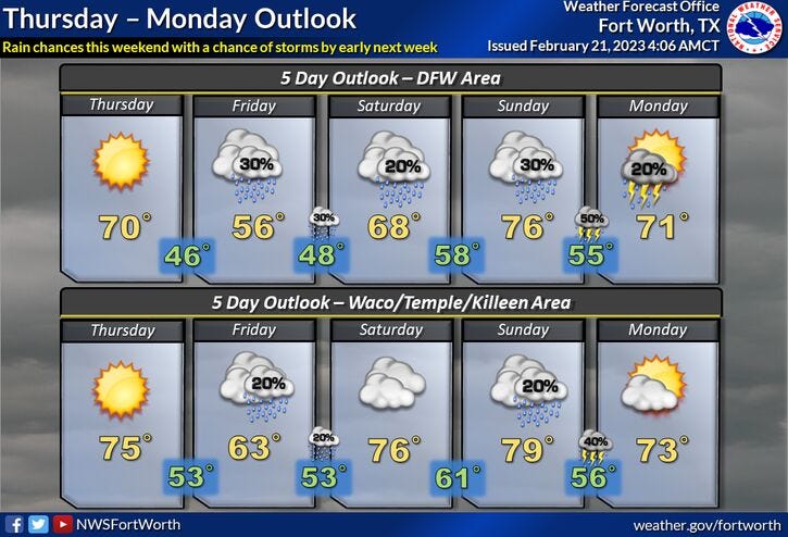
Your weekend doesn't look too bad. A slight chance of showers on Saturday with highs in the low sixties and we'll be back in the seventies on Sunday. Rain chances increase towards evening and especially overnight into early Monday morning. Afternoon highs Monday will be in the upper sixties.
*Yest Rain: 0.00"; Yest High: 80; Low: 56
*Today’s Averages: High: 62; Low: 42
*Record high: 95 (1996); Record low: 18 (1939)
*February Rain: 3.48"; Surplus: 1.62"
*2023 Rain: 4.86"; Surplus: 0.47"
*Sunrise: 7:05am; Sunset: 6:19pm
Today: Partly cloudy, windy and very warm. High: Mid 80s. Wind: SW 15-25, G30 mph.
Tonight: Increasing clouds, windy and mild. Scattered showers and isolated storms towards daybreak. Low: Low to mid 60s. Wind: SSW 20-30, G40 mph.
Tomorrow: Morning showers and isolated storms, nothing severe. Then decreasing clouds, VERY windy and warm. Lowering humidity. High: Near 80. Wind: SW 20-30, G45 mph.
Thursday: Mostly sunny and a bit cooler. High: Mid to upper 60s.
Friday: Cloudy, breezy and chilly. A slight chance of showers. High: Near 50.
Weekend: Cloudy, with warming temperatures. Mostly cloudy and mild. A slight chance of showers Saturday. Better rain chances late Sunday night. Highs: Low to mid 60s on Saturday, low 70s on Sunday.
Monday: Mostly cloudy, with a chance of showers and storms. High: Mid 60s.
Related

LISTEN on the Audacy App
Tell your Smart Speaker to "PLAY 1080 KRLD"
Sign Up and Follow NewsRadio 1080 KRLD