We're starting off this morning with plenty of cloud cover, wind, and mild temperatures for this time of the year. Sunshine will break out around lunch time with afternoon highs in the mid-90s. South winds will gusts as high as 35 mph.
By this evening, the dry line will work its way into north Texas producing some scattered showers and storms. If the cap breaks, some of these storms will become severe with hail and wind being the threats.
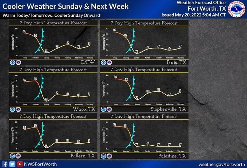
Storms dissipate after midnight, but reform late tomorrow afternoon along a strong cold front. Heaviest rain will be south and east of DFW. Afternoon highs will reach the low 90's.
It will turn windy and much cooler tomorrow evening into Sunday morning as the rain presses to our south and east. Morning lows will drop into the low to mid fifties on Sunday, with afternoon highs only in the mid-60s...unless the clouds clear out, then we'll jump up into the seventies. There's also a slight chance for some scattered showers and storms behind the front.
 Cooler WeatherNational Weather Service
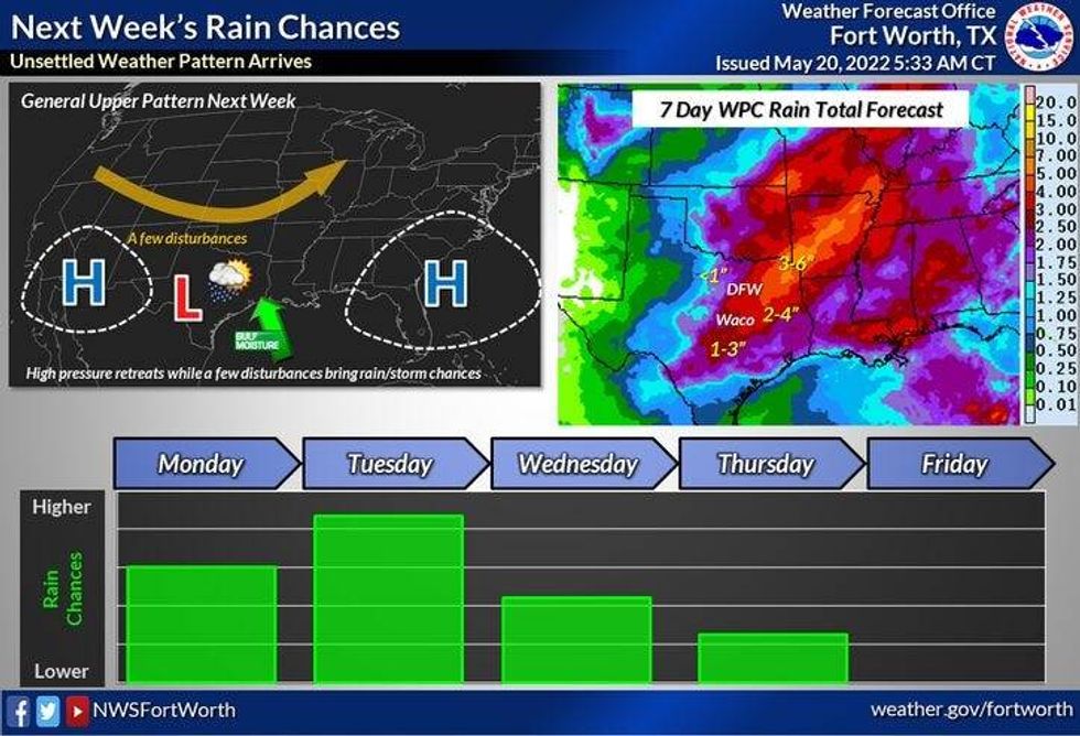
By next week, there's a good chance of off and on showers and thunderstorms Monday through Wednesday evening. Some of the rain could be heavy at times. Flooding is also a possibility. High temperatures next week will hold in the seventies! I'll have more on our flooding potential on Monday.
*Yest Rain: 0.00"; *Yest High: 96; Low: 73
*Today's Averages: High: 85; Low: 66
*Record high: 98 (1922); Record low: 48 (1981)
* May rain: 1.63"; May deficit: 1.33"
*2022 rain: 8.40"; 2022 deficit: 6.37"
*Sunrise: 6:25am; Sunset: 8:25pm
 Next Week WeatherNational Weather Service - Fort Worth
Today: Morning clouds, afternoon sun. Windy and hot. High: Mid 90s. (Record 98 degrees). Wind: SSE 15-25, G35 mph.
Tonight: Scattered storms, some severe. Not everyone will see rain. Threats: Hail and wind. Low: Low to mid 70s. Wind: SSE 15-25, G30 mph.
Tomorrow: Morning clouds, afternoon sun. Late afternoon cold front increases shower and thunderstorm chances. Isolated severe. High: Low 90s. Wind: SSE 15-25, G30 mph.
Tomorrow night: Isolated showers and storms. Windy and MUCH cooler. Low: Low to mid 50s!
Sunday: Mostly cloudy, breezy and cool. Isolated showers. High: Mid to upper 60s.
Monday - Wednesday: Cloudy and mild. Scattered showers and storms. Rain could be heavy at times. Highs: Mid to upper 70s.
Thursday: Partly cloudy, breezy and pleasant. Humidity drops. High: Upper 70s.

LISTEN on the Audacy App
Sign Up and Follow NewsRadio 1080 KRLD
Facebook | Twitter | Instagram
 Audacy