

One of the most significant "weather events" of winter is shaping up from Wednesday into Christmas Eve and the impacts may become life-threatening across parts of Minnesota, the Upper Midwest, Great Lakes, Ohio Valley and New England, as a sprawling storm whips up a long list of weather risks.
We've seen more snow, stronger winds and colder temperatures, but it's the combination of these elements that will create blizzard conditions from falling and blowing snow by Friday and Saturday as powerful 30-50 mph winds whip up on the backside of a massive storm that will pull arctic air into much of the USA east of the Rockies.
What is a Blizzard:
A blizzard means that the following conditions are expected to prevail for a period of 3 hours or longer. Sustained wind or frequent gusts to 35 miles an hour or greater; and considerable falling and/or blowing snow (i.e., reducing visibility frequently to less than a ¼ mile).
It's easy to forget that blizzard conditions can arise even when the sun is shining, from snow already on the ground blowing and drifting and dropping visibilities to near zero. Thank you Google for this reminder.
Winter Storm Headlines:
- Best travel weather comes today (Tuesday). Conditions may improve slightly on Christmas Eve, especially PM hours, but travel will range from slow to treacherous right through the holiday weekend.
- Snow starts up Wednesday morning with a potential for 5-10" for much of the area by the time it tapers Thursday PM. This should be a plowable snowfall.
- What will potentially make this a crippling storm is the combination of fallen snow, winds gusting to 45 mph (Friday) and wind chills as cold as -30 to -40F. A Trifecta of Pain. My sense is that Friday will be the worst day for ground blizzards and dangerous wind chills, even though the accumulating snow will be over by then.
- Winter Storm Watches and Wind Chill Watches are in effect. I suspect they will be upgraded by the Twin Cities National Weather Service to Blizzard Warnings and Wind Chill Warnings, but that may not happen until late tomorrow or Thursday morning.
- Frostbite potential will be significant from Thursday night into Saturday morning. With a wind chill of -40 exposed skin can become frostbitten in less than 10 minutes.
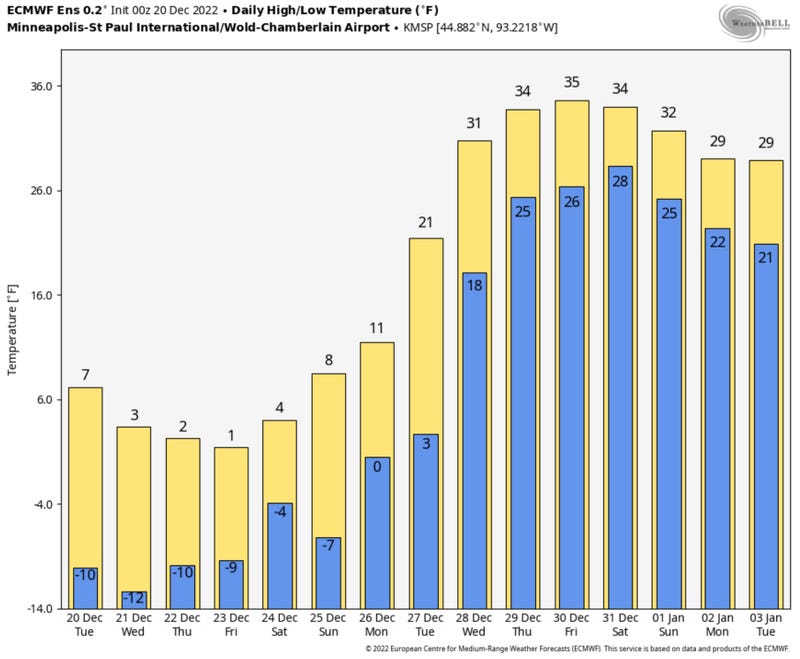
- Subzero daytime highs possible at MSP on Thursday, for only the 3rd time since 2000.
- If the daytime high on Christmas Eve is colder than 4F it will be the coldest MSP high for December 24 since 2000. Fun.
- 30s (above zero) return by the middle of next week. There will be an early January thaw, even a little drizzle in time for New Year's Eve! Keep the faith. This too shall pass.
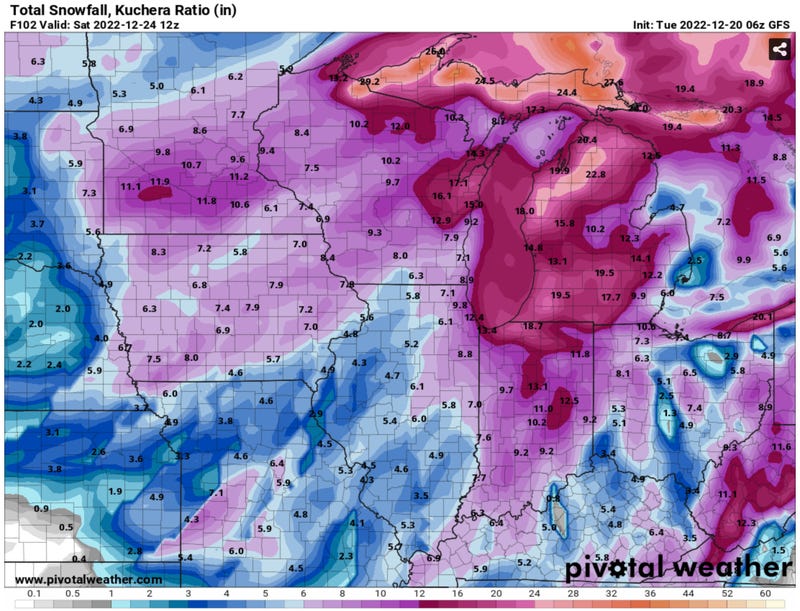
How Many Inches Paul? Surely this will be chiseled into my tombstone someday. The 6z GFS model from NOAA suggests 10"+, which may be a little high. I'm comfortable (wrong word) with a 5-10" prediction, but it's still too early to know who will pick up 10" or more, where the axis of heaviest snow will set up. Suffice to say this should be plowable.
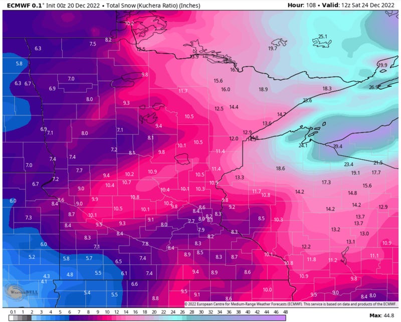
Predicted Snowfall by Christmas Eve: ECMWF. Here is the 00z European model forecast for accumulated snow, showing the heaviest snow generally north and east of MSP. Again, it's early to try to get too cute when it comes to specifics. It'll be enough snow to bring out the plows, and it will be a very light, fluffy, powdery snow that is prone to blowing and drifting, setting the stage for blizzard conditions Thursday into Saturday morning.
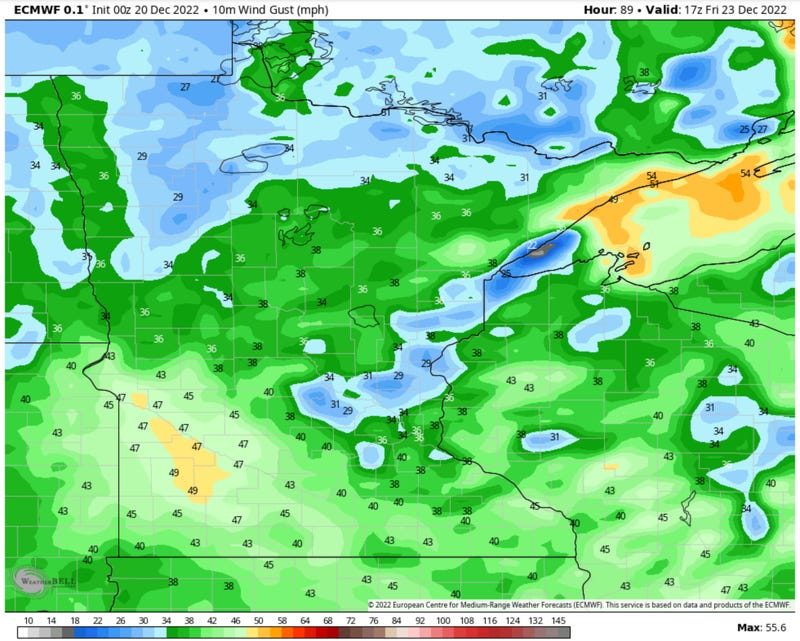
The Gales of December. Model guidance shows the strongest winds coming Friday, with some of the strongest gusts over the Buffalo Ridge of southwest Minnesota. In general, drifting (and a potential for ground blizzards and zero-visibility) will come south and west of the Twin Cities over open terrain with few trees. It will look like the Yukon out there by Friday.
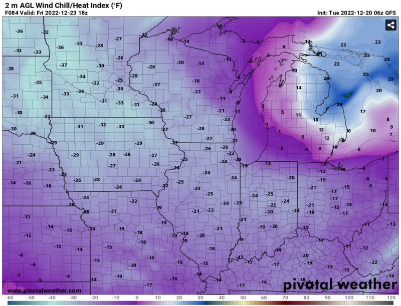
Predicted Midday Friday Wind Chills. With temperatures at or below 0F and winds gusting over 30-40 mph it won't be too hard to get a wind chill in te -30 to -40F range, even in the Twin Cities. Sorry urban heat island - not much help during a blizzard. This is the greatest concern. You slide off the road or have a bender-bender, what would normally be a minor nuisance or hassle could become life-threatening if you have to walk a long distance to get help.
The rule of thumb is to wait in your vehicle and call for help. Run your vehicle's engine and heater sparingly, and make sure snow isn't covering your exhaust (to prevent carbon monoxide poisoning, which can be fatal).
Listen to the Pros at the Twin Cities National Weather Service. During the weather discussion at MPX, the local Twin Cities office in Chanhassen, they didn't mince words: "high end, life threatening event". The danger isn't the snow itself, but that snow whipped along by 30-50 mph winds creating conditions that may prevent you from reaching your destination, or even worse, spinning out or sliding into a ditch. If THAT happens and you try to get help, the result could very well be frostbite or hypothermia (potentially fatal drop in body temperature). Again, in the age of smartphones, use it and wait for help to reach you, if you find yourself in this scenario later in the week.
I wish I had better news for Christmas travelers. I would try to get out of Dodge Wednesday morning, before much snow accumulates OR wait until Saturday afternoon, when the sun will be out and winds will taper (slightly). No idea how long it will take MnDOT to dig out our roads.
Even the interstates will experience drifting snow and many airports will have to close, especially Friday.
High winds may bring down tree limbs and spark spotty power outages - although I expect most of us to maintain power throughout this 3-4 day tantrum of snow, wind and dangerous cold.
This too shall pass - but the only silver lining I can think of at this moment: yes Virginia, there is a Santa Claus - and it's going to be a VERY white (and windswept) Christmas!
PS: An early Christmas and Hanukkah gift to you and yours!
Related
