
We’re expecting a small return of the heat this week, but it is nothing compared to what is happening on the West Coast where record temps have been a very big concern.
Meanwhile, the East Coast and the south have been getting torrential rains that have caused major flooding. It's been especially difficult for Jackson, Mississippi where many residents are still without drinking water.
WCCO’s Chief Meteorologist Paul Douglas breaks down what is happening both in Minnesota and across the country with this week’s weather trends.
California is burning up
There have always been heat waves in California, but Douglas says they are getting hotter and that is a concern.
“The heat waves are trending even hotter as background temperatures increase,” explains Douglas. “You know, we've warmed up nationally two, three degrees. Doesn't sound like much, but that does increase the potential that when a naturally occurring heat wave occurs, it's going to be amped up. It's going to be juiced and that's what we're seeing across much of the nation.”
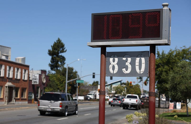
Tuesday’s temperature hit 116 in Bakersfield, California and it was even 110 to 115 in the eastern suburbs of the San Francisco Bay Area which is extremely unusual.
“Quite honestly, a lot of people do not have air conditioning in their homes,” Douglas says about the Bay Area. “They may have it in their vehicles and a lot of the warehouses that these big delivery companies use, are not air conditioned. So just an untenable situation, once again, extreme stress. Officials are pleading with people to set their thermostats up to 78 degrees and hopefully we can avoid rolling blackouts out there.”
Related

And yes, on top of all of this heat, there are still wildfires burning in California and serious concern this heat will only make the parched state worse heading into the fall.
Daytime highs are bad but watch those nighttime lows
Yes, 115 degrees during the day is a dangerous temperature for humans. But Douglas says the real problems occur when it doesn’t cool off at night.
“We all tend to get fixated on the daytime highs as we should,” Douglas told WCCO’s Vineeta Sawkar. “But it's the nighttime lows that are the big killer. If you go three or four nights in a row with nighttime temperatures above 80, the body just can't recover at night. Especially, obviously, if you don't have air conditioning. So it’s a tough situation.”
It's going to stay very hot for much of the west, right through the end of the week according to Douglas, and those temps are not limited to just California.
“It's 100 degree heat in Montana and parts of Utah,” Douglas said. “A little unusual, many areas setting all-time records, beating those all-time September records by ten degrees.”
Minnesota will warm up slightly, but nothing like it is out West
We're just getting a taste of heat in Minnesota the rest of this week. Call it a mini-heatwave for September.
“We’re just getting skimmed, brushed by this heatwave,” says Douglas. “Mid-eighties today. I think it will hit 90 tomorrow before some strong storms erupt late tomorrow, tomorrow night, and a few could be strong. Maybe severe, especially central and northeastern Minnesota.
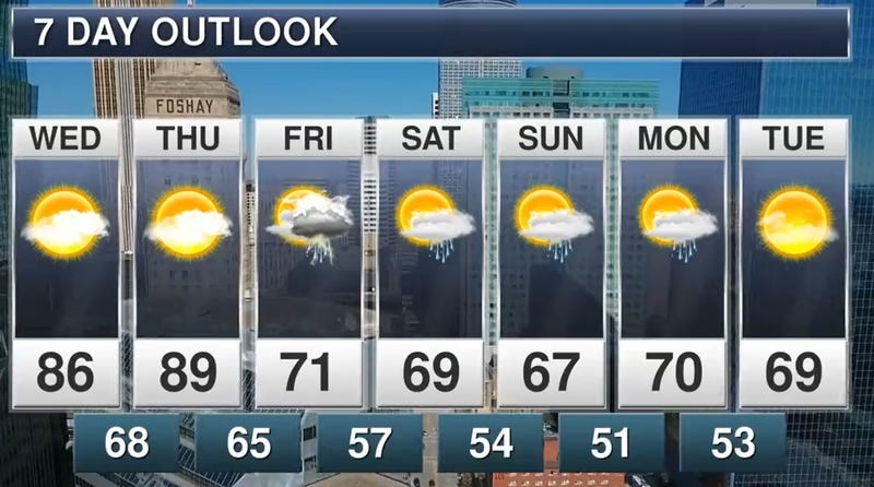
Douglas says we’ll cool off a little bit with some much-needed light rain Friday.
“Doesn't look like much,” Douglas says. “Quarter inch, maybe some half inch amounts before we cool off. I think clouds will linger much of Saturday.
Could be some more rain south of the metro near the Iowa border. Sunday looks like the nicer day, sunnier day. Once again, 70-72 for a high.”
It will feel more like September by this weekend, and then more sixties and seventies next week. He says there could be some low eighties sneaking in next week as well, as we start that inevitable transition into fall.
Those days are getting much shorter too if you hadn't noticed. Sunrise is now at 6:44 a.m. with sunset already as early as 7:39 p.m. in Minnesota.
“No significant drama compared to the flooding out east and the record heat out west,” Douglas explains. We are, you know, in a relatively good spot right here.”