

DETROIT(WWJ) -- We made it all the way to mid-November with no more than a few flakes... but there was some sticking snow in metro Detroit on Sunday morning.
Many areas across metro Detroit saw their first dose of the white stuff this season, with a mix of snow and rain expected throughout the day.
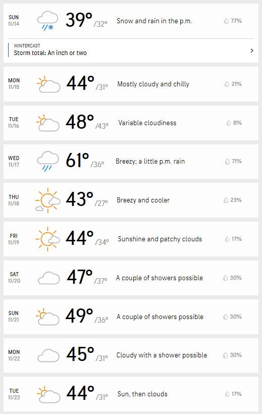
Most places in the area were expected to see about an inch of accumulation, with some spots seeing slightly higher accumulation totals.

The National Weather Service in Detroit says most of the accumulating snow is on grassy and elevated areas, but roads could still be a bit slippery.
Sunday's snow comes after a Saturday full of off-and-on rain, and AccuWeather meteorologist Brian Thompson says that could make for a mess on the roads.
"A lot of that will be on non-paved surfaces, but there could be some slick spots if the snow comes down a little harder for awhile," he said.
The WWJ Traffic Center is reminding drivers to use caution on the roads and take it slower than usual when the roads are slick.
Areas north and west of Detroit have the best chance for the most snow — and with that the best chance for some traffic trouble.
The NWS says while there's a chance for rain and snow showers into the early evening, accumulation would be light.
The high temperature Sunday will only be around 38 degrees.
Related

Looking into next week, Monday and Tuesday should be dry and bit less chilly, getting into the 40s in the afternoon, Thompson said. There's another chance for some rain on a warmer Wednesday, with a forecasted high of around 60 degrees.
Here's the 10-day AccuWeather forecast for Detroit:
Stay with WWJ Newsradio 950 for your latest weather and traffic updates, every 10 minutes on the :08s. CLICK HERE to listen live!
Related
