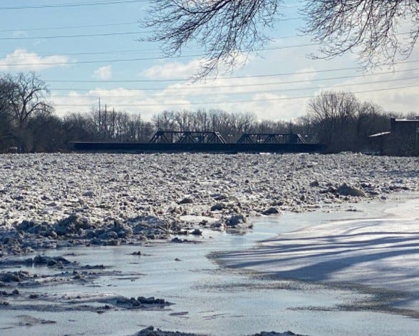

MONROE CITY (WWJ) - Severe flooding was observed at the River Raisin late Friday night, prompting officials to upgrade earlier flood warnings from moderate to severe.
Related
![River Raisin ice jams cause flooding, road closures in Monroe [PHOTOS, VIDEOS]](https://radioimg.audacy.com/aiu-media/Screen-Shot-20220218-at-104415-AM-fae9c328-e770-4fde-998f-6395dde4ab7f.jpg?crop=16:9)
The National Weather Service said homes along the western edge of the river in Monroe City are most at risk for significant flood waters and residents should take precautions now.
WWJ's Mike Campbell was on scene Friday morning as the River Raisin swelled past the 9 feet flood stage due to an ice block, causing waters to rise and flood into neighborhoods and over roads. Authorities made several water rescues throughout the day Friday as drivers became stranded in neighborhoods off Michigan Ave.
Emergency management officials said the river was expected to crest at noon on Friday, but it continued to rise, reaching 11.3 feet after nightfall.
Emergency officials changed flood bulletins from moderate to major around 7:30 p.m. Friday evening; the warning remains in effect until further notice as flood waters are expected to fluctuate between 10 and 12 feet.
As temperatures fell, rescue crews and tow trucks struggled to get to drivers who were stuck in flood waters that had frozen over -- according to one report, firefighters had to use a ladder to reach one women stranded in the middle of a street frozen with water.
Officials urged residents and drivers to take extreme caution and to stay away from flood waters.
"Turn around, don't drown when encountering flooded roads," the National Weather Service warned. "Most flood deaths occur in vehicles."
To learn more about what to do in a flood emergency, visit here for safety tips.
This is a developing story. Stay tuned to WWJ Newsradio 950 for the latest traffic and weather updates every 10 minutes on the 8s. >>> LISTEN LIVE!

Related
![Advisory: Ice blockage could lead to flooding for residents along St. Clair River [VIDEO]](https://radioimg.audacy.com/aiu-media/river-ice-5d842a19-a1fb-40ac-8b9d-c615bc51caf8.jpg?crop=16:9)