Buffalo, N.Y. (WBEN) - Lake effect snow remains on the move across Western New York today as a band of snow is again crossing the Buffalo metro area and will eventually settle south of the city. The snow will be heavy at times but not remain in any one spot for too long, which will hold accumulations down but still present times of extremely poor visibility and road conditions during the peak drive times.
At 1235 PM, a band of heavy lake effect snow was located across southern Niagara County, Buffalo north towns, and western Orleans county. This band will drop rapidly southward across the Buffalo metro area over the next couple hours. Expect snowfall rates of 1 to 2 inches per hour, with areas of blowing snow as this weather moves through. The band will continue to move south late this afternoon, exiting the Buffalo south towns around 3 p.m. Conditions can deteriorate rapidly in winter weather situations. Be prepared for snow or ice covered roads. Slow down and allow extra time when traveling. Locations impacted include... Buffalo, Cheektowaga, West Seneca, North Tonawanda, Clarence, Lackawanna, Batavia, Kenmore, Depew, Amherst, Tonawanda, Lancaster, Hamburg, East Aurora, Medina, Williamsville, Darien Lakes State Park, Grand Island, Evans and Elma.
The snow should wind down for the metro Buffalo area by late afternoon and for the southern portion of the region Wednesday evening.
CHECK: WBEN Closings
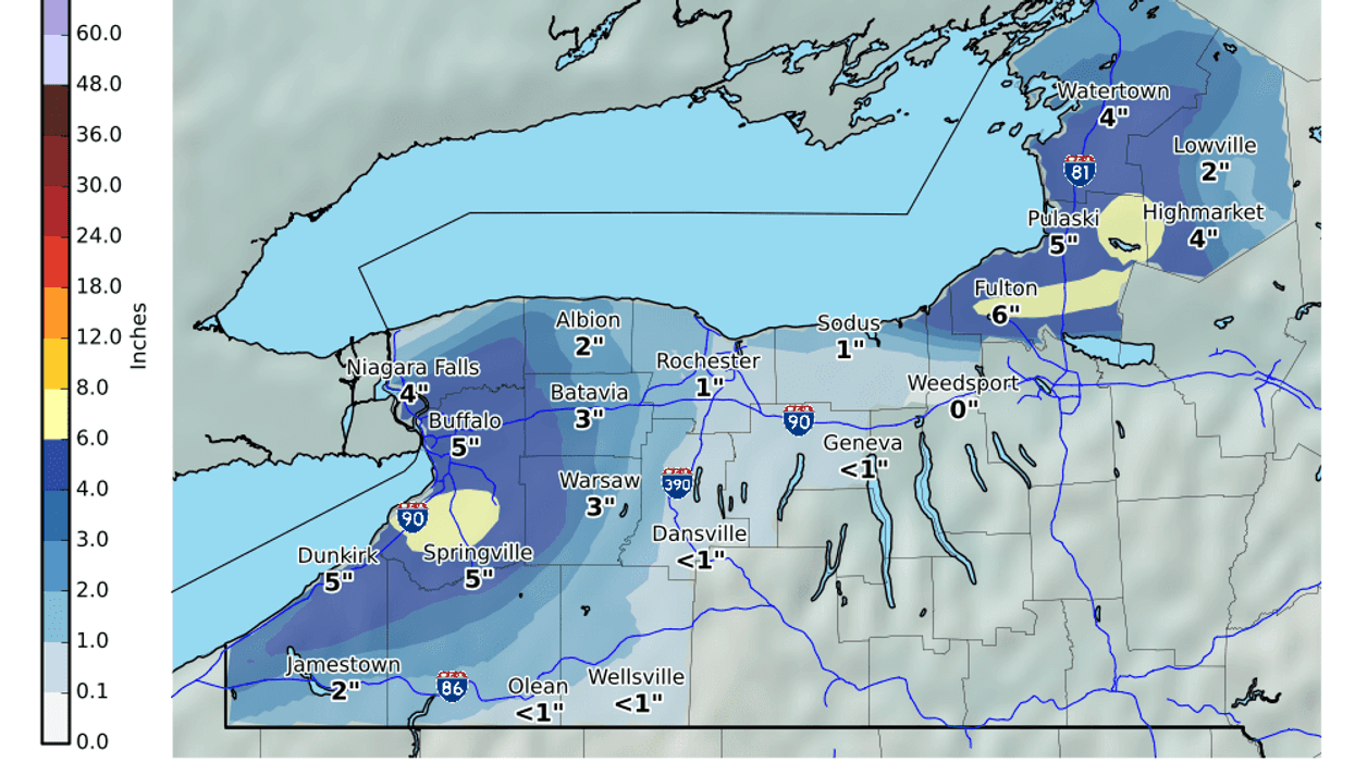
With gusty winds expected, driving conditions where the snow is falling may be extremely poor at times. The above map is a forecast of snow accumulation through 7am Thursday.
Lake effect snow is pushing northward this morning with snow to soon be falling across #Buffalo, the northtowns and out towards #Batavia. Allow extra time to reach your destination this morning as roads become snow covered and visibilities become poor. #nywx pic.twitter.com/W0QKnvxziM
— NWS Buffalo (@NWSBUFFALO) December 11, 2019WINTER WEATHER ADVISORY REMAINS IN EFFECT UNTIL 5 PM EST THISAFTERNOON* WHAT...Lake effect snow. Additional snow accumulations of up to2 inches in the most persistent lake snows. Winds gusting ashigh as 40 mph.* WHERE...Northern Erie and Genesee counties.* WHEN...Until 5 PM EST this afternoon.* IMPACTS...Plan on slippery road conditions. Areas of blowingsnow could significantly reduce visibility. The hazardousconditions could impact the evening commute.PRECAUTIONARY/PREPAREDNESS ACTIONS...Lake effect snow will fall in relatively narrow bands. Iftraveling, be prepared for rapidly changing road conditions andvisibilities.WINTER WEATHER ADVISORY REMAINS IN EFFECT UNTIL 8 PM EST THISEVENING* WHAT...Lake effect snow. Additional snow accumulations of 1 to3 inches in the most persistent lake snows. Winds gusting ashigh as 40 mph.* WHERE...Wyoming and Southern Erie counties.* WHEN...Until 8 PM EST this evening.* IMPACTS...Plan on slippery road conditions. Areas of blowingsnow could significantly reduce visibility. The hazardousconditions could impact the evening commute.PRECAUTIONARY/PREPAREDNESS ACTIONS...Lake effect snow will fall in relatively narrow bands. Iftraveling, be prepared for rapidly changing road conditions andvisibilities.WINTER WEATHER ADVISORY REMAINS IN EFFECT UNTIL 1 AM ESTTHURSDAY* WHAT...Lake effect snow. Additional snow accumulations of 1 to3 inches in the most persistent lake snows. Winds gusting ashigh as 40 mph.* WHERE...Chautauqua and Cattaraugus counties.* WHEN...Until 1 AM EST Thursday.* IMPACTS...Plan on slippery road conditions. Areas of blowingsnow could significantly reduce visibility. The hazardousconditions could impact the evening commute.PRECAUTIONARY/PREPAREDNESS ACTIONS...Lake effect snow will fall in relatively narrow bands. Iftraveling, be prepared for rapidly changing road conditions andvisibilities.