


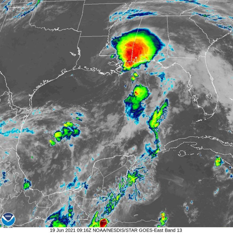
The National Hurricane Center said that as of 4:00am, the system we've been watching send rounds of rain onto the Gulf Coast had officially become Tropical Storm Claudette.
Forecasters said that as the system made it to about 45 miles southwest of New Orleans, it developed into a tropical storm.
"The system that we have been tracking for a few days finally has enough of a well-defined center and organized convection to be considered a tropical storm," Senior Hurricane Specialist Eric Blake said. "While the organization is not classical by any means, and there are some hybrid characteristics, the cyclone most resembles a sheared tropical storm, so the system is now Tropical Storm Claudette."
He said this happened as the storm was over land in coastal Louisiana, but with nearly all the impact to the east of the state.
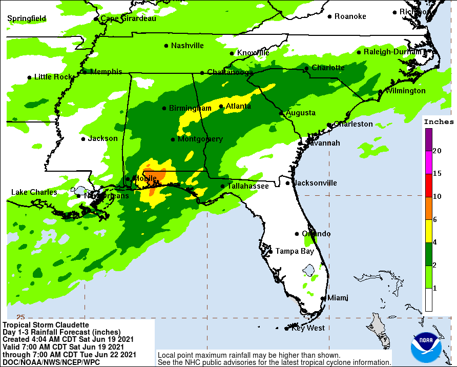
"Claudette is expected to produce heavy rainfall and life-threatening flash flooding across coastal Mississippi and Alabama, and the far western Florida Panhandle through the afternoon. Considerable flash, urban, and small stream flooding, will continue through the weekend along the central Gulf Coast, with flood impacts spreading northeastward into interior portions of the Southeast."
On the forecast track, the Hurricane Center says Claudette should move farther inland over Louisiana during the next several hours, then move across portions of the Gulf coast and southeastern states through the weekend.
It will be over the western Atlantic Ocean off the East Coast on Monday.
"Maximum sustained winds remain near 45 mph with higher gusts. Claudette is expected to weaken to a tropical depression by tonight and become a post-tropical cyclone on Sunday. The system is forecast to re-develop over the western Atlantic Ocean on Monday."
HAZARDS AFFECTING LAND
----------------------
RAINFALL:
Claudette is expected to produce rainfall totals of 5 to 10 inches with isolated maximum amounts of 15 inches across portions of the central Gulf Coast. Life-threatening flash flooding impacts are possible across coastal Mississippi and Alabama, and the far western Florida Panhandle through the afternoon. Considerable flash, urban and small stream flooding impacts as well as new and renewed minor to isolated moderate river flooding are likely across the remainder of the Central Gulf Coast.
As the system continues to lift northeast through the weekend, heavy rain will expand across central Alabama, central and northern Georgia, into the Piedmont of the Carolinas, resulting in rainfall totals of 3 to 6 inches with isolated maximum amounts of 8 inches. Flash, urban, small stream and isolated minor river flooding impacts are possible.
STORM SURGE:
The combination of storm surge and the tide will cause normally dry areas near the coast to be flooded by rising waters moving inland from the shoreline. The water could reach the following heights above ground somewhere in the indicated areas if the peak surge occurs at the time of high tide...
Morgan City, LA to Okaloosa/Walton County Line, FL...2-3 ft
Lake Borgne and Mobile Bay...2-3 ft
Lake Pontchartrain and Lake Maurepas...1-2 ft
Okaloosa/Walton County Line, FL to Panama City, FL...1-2 ft
Pensacola Bay, Choctawhatchee Bay, and Saint Andrew Bay...1-2 ft
Cameron, LA to Morgan City, LA...1-2 ft
Vermilion Bay...1-2 ft
WIND:
Tropical storm conditions should continue along the coast in the warning area today.
TORNADOES:
A few tornadoes are possible today and tonight across southern Mississippi, southern Alabama, the western Florida Panhandle, and southwest Georgia.
LISTEN on the Audacy App
Sign Up and Follow Audacy
Facebook | Twitter | Instagram


