


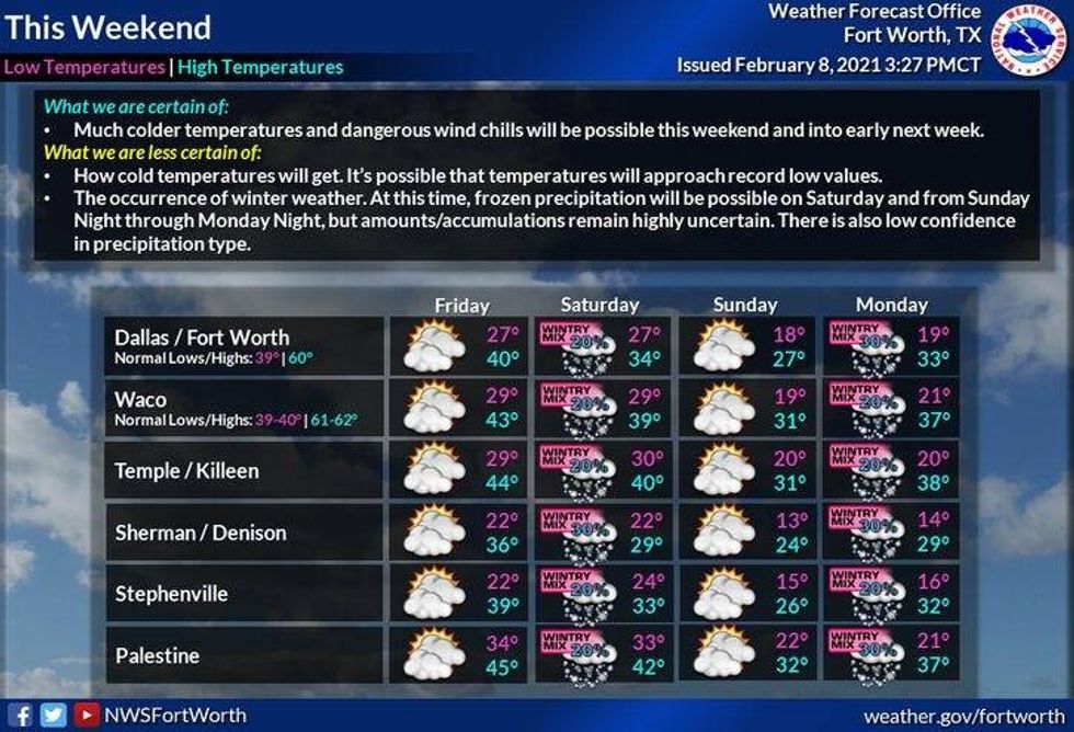
After Thursday's event across the southern parts of north Texas into central Texas, we get a little bit of a break Friday Saturday and Sunday.
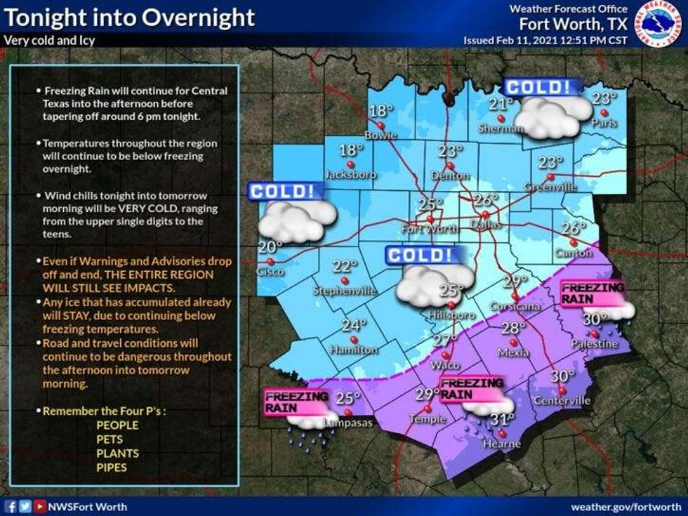
Temperatures during the period will hover in the mid to upper 20s. There may be some light freezing drizzle tomorrow morning and then again on Saturday morning.
 NWS
NWS
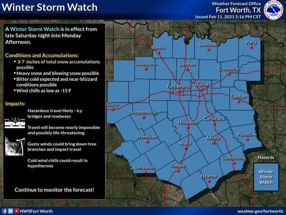
The big weather makers arrive the 2nd half of Sunday into early Monday.
Bitter cold air filters in with temperatures in the teens for highs by Monday and morning lows in the single digits. We might approach 0 or below early Tuesday morning depending on how much snow we see late Sunday into early Monday.
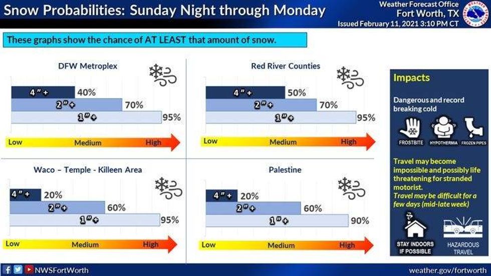
Right now the data continues to be consistent for 4 to 6" of snow possible across all of North Texas. Amounts will be tweaked down or up as we get closer to this event.
This will put us in a very dangerous situation for all of next week with snow packed roads with dangerously cold temperatures. Readings will remain in the teens and twenties for highs, with morning lows in the single digits and teens.
To make matters worse, another system may impact our weather with a wintry mix next Wednesday. Stay tuned for updates on that forecast.
7-Day Headlines:
* Winter Weather Advisory until noon.
* Patch freezing drizzle Friday morning. Better chance Sat. A.M.
* Wintry mix possible by Saturday afternoon and evening.
* Widespread snow Sunday into early Monday.
* Record breaking cold next week!!
* Morning lows close Tuesday near to zero…or below!
* Another possible snow storm late Tuesday into Wednesday.
_____________________
*Yesterday's High: 29; Low: 24
*Today's Averages: High: 60; Low: 39
*Records: High: 84 (1962); Low: minus 8 (1899) *Coldest ever*
______________________
*Yesterday's rain: Trace; Feb. rain: 0.01"; Feb. deficit: ">
*2021 Rain: 0.86"; 2021 Deficit: ">
*Sunrise: 7:14am; Sunset: 6:11pm
______________________
*Winter Storm Watch Sunday into early Monday*
Thursday night: Cloudy, windy and cold. Isolated FZDZ after 3am. Low: Low to mid 20s. Wind: N 10-20 mph.
 NWS
NWS
 NWS
NWS
Friday: Isolated A.M FZDZ, then spotty afternoon FZDZ (south of I-20). Windy and cold. High: Near 30. Wind: N 15-25 mph.
Friday night: Cloudy with areas freezing drizzle after 3am. Low: Mid to upper 20s. Wind: N 10-20 mph.
Saturday: Scattered wintry mix, picking up by evening. High: Upper 20s. Wind: N 10-20 mph.
Sunday: *Winter Storm Warning?* Cloudy, windy and cold. Snow and blowing snow likely (Accumulation forecast to come Sunday morning). High: Upper 20s early, falling into the teens.
Monday: Chance of snow and blowing snow before 6am, then cloudy, windy and BITTER COLD! Low: 5-10; High: Low teens.
Tuesday: Cloudy. Bitter cold! Chance of snow by evening. Low: Near zero; High: Mid teens.
Wed: Cloudy and cont. cold. Chance of accumulating snow. Low: low teens. High: Near 20.
Thursday: Cloudy and cold. Snow flurries and blowing snow. High: Near 20.
 NWS
NWS
_____________________