


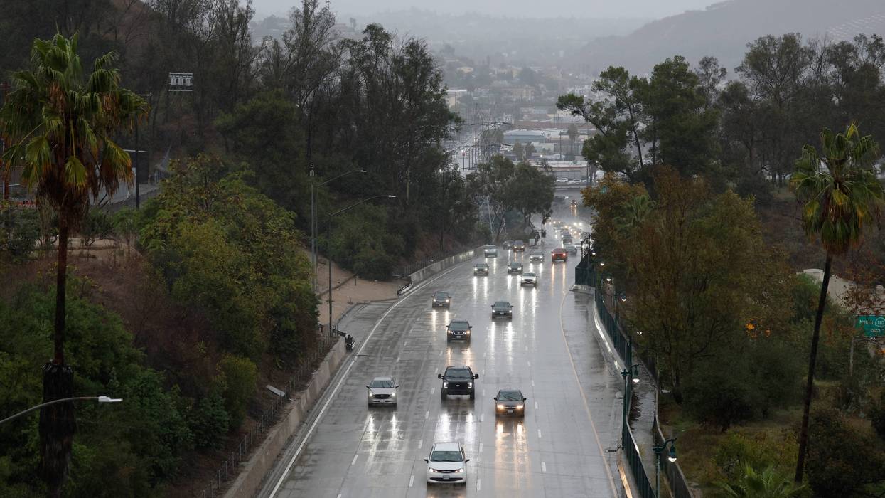
A "very dangerous" atmospheric river storm is expected to dump rain on Southern California beginning Tuesday evening and continuing through Christmas and into the weekend, prompting evacuation warnings and orders for residents near recent burn areas, most notably the Palisades and Eaton fires.
Some light rain began falling late Tuesday morning in select areas stretching from Long Beach to the San Gabriel Valley, but forecasters said that was just a warm-up for the storm still to come.
Speaking at a Tuesday afternoon news conference, NWS meteorologist Ariel Cohen said lower elevations such as downtown Los Angeles and points south will likely get 2 to 4 inches of rain, but areas to the north and west such as the Santa Monica Mountains, San Fernando Valley, San Gabriel Mountains and foothills, Hollywood Hills and northern sections of the L.A. basin could get 4 to 8 inches.
"In fact, some of our computer models projections indicate over a foot of rain falling in total over the mountains by the end of this week," he said. "Now I want to clarify, all of this rain will not be falling all at once. Rainfall rates may only approach or marginally exceed the debris flow thresholds, so while debris flows on the burn scars will be possible, in general they should be minor to moderate. However, with as much total rain as what we're expecting, widespread significant flooding will likely occur in urban and poor drainage areas, especially in and around the higher terrain. There will almost certainly be numerous rockslides and mudslides along with areas of severe flooding in urban locations and along freeways, which is why being out on the roads will be exceptionally dangerous."
He added, "If you're planning to be out on the roads during the Christmas holiday, please reconsider your plans. By the time we get to late Wednesday through Friday, many areas will likely be experiencing significant flooding, along with rockslides and mudslides, especially through the high terrain and canyon roadways."
A flood watch will be in effect from Tuesday afternoon through Thursday evening for much of Los Angeles County, with mud and debris flows possible across foothill and mountain areas, including recent burn scars, according to the National Weather Service.
"The south facing mountains and foothills as well as the coastal and valley areas below them were designated as a high risk area for dangerous and widespread flooding concerns," according to the NWS. "Some of the latest high resolution-model data show rain rates locally reaching 1.50 inches per hour, especially across favored south facing slopes."
Forecasters said 3 to 6 inches of rain is expected in coastal and valley areas by the end of the day Thursday, with 5 to 11 inches anticipated in foothills and mountains. Rain is expected to fall at rates ranging from 0.6 inches to 1.25 inches per hour in many areas, with some localized downpours reaching up to 1.5 inches on south-facing mountain slopes, dramatically raising the risk of flooding and debris flows.
Los Angeles city and county officials issued a series of evacuation warnings and orders in advance of the storm, which is also being described as a "Pineapple Express" event, picking up excessive moisture as it moves across the Pacific Ocean and makes landfall.
The city of Los Angeles issued evacuation warnings that will be in effect from 11 a.m. Tuesday through 11 p.m. Thursday for residents of Pacific Palisades and Mandeville Canyon near the Palisades Fire, and south of Runyon Canyon near the Sunset Fire area.
"The Los Angeles Police Department will go door-to-door to visit each high-risk home with evacuation orders," according to Los Angeles Fire Department spokeswoman Lyndsey Lantz.
Los Angeles County officials, meanwhile, issued evacuation warnings for residents near the Palisades, Eaton, Agua Dulce, Lidia, Franklin, Bridge, Canyon, Owen, Hurst and Kenneth fires. Those warnings will also begin at 11 a.m. Tuesday. Sheriff's deputies were also going door-to-door to high-risk residences to notify them of evacuation orders.
Sheriff Robert Luna said that as of Tuesday morning, 124 homes in the sheriff's unincorporated coverage area were under evacuation orders. County Public Works Director Mark Pestrella said roughly 260 other homes in various incorporated cities are also being placed under evacuation orders and will be visited by local police departments, including the LAPD.
Luna urged residents to heed the evacuation orders and warnings, saying those who fail to do are "putting your lives at risk."
"Start preparing now," Luna said. "Identify important items such as medications, important documents and other essential items in case you must leave quickly."
He noted that once the rain begins, "debris from the burn scar areas may impede the roads, and it may be difficult to leave once the storm begins."
"Do not wait until conditions become dangerous to act," Luna said.
He also urged people who may have elderly or disabled residents in the warning areas to "make sure you have communicated with them and ... coordinated a plan to get them out."
Residents can check the evacuation status of their neighborhoods at protect.genasys.com.
In Orange County, mandatory evacuation orders will take effect at 8 a.m. Wednesday near the Airport Fire burn scar, affecting areas of:
-- Trabuco Creek, including the RC Airport, fire station, campground/park and school;
-- Bell Canyon, including Starr Ranch; and
-- Hot Springs Canyon, including Lazy-W Ranch.
A reception center for displaced OC residents will be opened at the Foothill Ranch Library Program Annex adjacent to the library at 27002 Cabriole Way. The OC Animal Care shelter at 1630 Victory Road in Tustin will be available to care for evacuated residents' small pets. Large animal owners can contact OC Animal Care at 714-935-6848, or 714-259-1122 after hours, for sheltering options.
Road closures in the Orange County evacuation area will also be in place on Trabuco Canyon Road at Rose Canyon; Plano Trabuco near Robinson Ranch; Grey Rock at Bell Canyon; and Hot Springs Canyon at Ortega Highway.
In addition to the rain, the NWS predicted "strong and gusty southeast to south winds" from Tuesday through Christmas Day.
"Widespread gusts of 35-55 mph are highly likely across all areas," forecasters said, adding that gusts of 60 to 80 mph are possible in L.A. County mountains and deserts beginning at noon Tuesday and continuing through 3 p.m. Thursday.
The most powerful portion of the storm is expected in the area late Tuesday night into Wednesday, with showers continuing into Christmas Day on Thursday, and a second trough pushing into the region Friday into Saturday.
Forecasters said the intensity and duration of the rains will dramatically increase the risk of debris and mud flows.
Want to get caught up on what's happening in SoCal every weekday afternoon? Click to follow The L.A. Local wherever you get podcasts.
"The combination of increasingly saturated soil and the strong winds will bring the potential for widespread downed trees and power lines, especially in areas under a High Wind Warning," according to the NWS. "Once again, this is a very dangerous holiday storm. Anyone traveling on Christmas Eve or Christmas Day will need to exercise extreme caution. Make sure to take the proper protective actions before the storm hits."
The city of Los Angeles' Emergency Operations Center was activated Monday in anticipation of the storm and to help coordinate response efforts by the Emergency Management Department, police and fire departments and county Public Works officials.
"Los Angeles city personnel continue preparing for the storm this holiday week," Mayor Karen Bass said in a statement. "First responders, public works crews, and utility personnel are ready to respond to potential impacts due to the weather. Angelenos planning to travel to spend time with family and loved ones this holiday week should follow official guidance, use caution on the roads, plan ahead, and stay informed. Sign up for emergency alerts at NotifyLA.org."
Residents across the county can visit lacounty.gov/emergency to register for county emergency alerts, and to access links for additional local alert systems managed by other municipalities.
According to the mayor's office, the Los Angeles Fire Department will have stepped-up staffing in place to respond to swift-water rescues or mud and debris flows. Crews from the Department of Water and Power, Street Services and L.A. Sanitation are also on standby.
Free sandbags are being offered at all fire stations throughout the city. County officials were also providing free sandbags.
While the worst of the storm will likely be Wednesday, periods of rain, possibly heavy at times, are expected on Christmas Day. Moist south to southwest flow will continue to usher in sporadic showers to the area Friday and Saturday, though rain amounts by that time should be under a quarter inch per hour.
Snow is not expected to be a major factor with the storm, with levels dropping to around 7,000 feet Thursday and Friday.
Follow KNX News 97.1 FM