Thursday morning started mild and muggy with temperatures near 70 degrees and extensive low cloud cover. The first in a series of disturbances will head into the Central Plains states Thursday afternoon, sparking numerous showers and severe storms well to the west and north of the Dallas-Fort Worth area. The worst of it looks to be in the eastern Texas Panhandle, western Oklahoma, and in Kansas. All modes of severe weather are possible in these areas.
It's this area of storms that will head toward North Texas by Friday morning in a weakened state. There could be some gusty winds and small hail during the morning commute Friday morning. Everything should press east of us by 12 p.m. Friday. More storms may develop east of DFW Friday afternoon and evening, but most of the area will stay dry. Afternoon highs on Thursday and Friday will reach the low 80s.
If you have outdoor weekend plans, stay weather aware late Saturday afternoon and through early Sunday morning. That's our greatest chance for severe storms across North Texas. All modes of severe weather are possible. Please keep in mind not everyone will see severe storms, but the majority of the area will get at least an inch of rain.
The lightning threat will mainly be tomorrow morning and then again late Saturday evening into Sunday morning across north Texas. Temperatures will be in the 80s this weekend with a ton of wind.
The weak cold front that'll slide through the area on Sunday will go stationary somewhere just south of the Dallas-Fort Worth area. We could see some more storms along this frontal boundary on Monday. It lifts to the north on Tuesday with a few scattered storms possible. By Wednesday, we may have our first decent cold front in a while come through the area bringing more severe weather to North Texas. Afternoon highs will be in the mid-80s with a ton of humidity next week.
Peak severe weather season is beginning across North Texas. Please have multiple ways to receive warnings and also download our Audacy app to listen to KRLD anytime, anywhere.
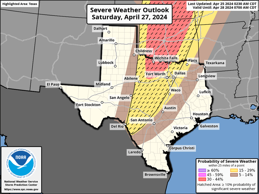 Severe weather outlook for Saturday, April 27, 2024.National Weather Service
7-Day Headlines:
* DFW Airport reached 85 yesterday.
* Humidity is back, and so is the wind.
* Quiet today, storms stay west of DFW.
* Increasing storm chances Friday morning, severity low.
* Severe threat late Saturday into early Sunday. All modes are possible.
* Monday looks quiet.
* Storm chances return Tuesday, especially by Wednesday.
_____________________________________________________
*Yest Rain: 0.00"; Yest High: 85; Low: 65
*Today's Averages: High: 78; Low: 58
*Record high: 91 (1902, 1925) Record low: 33 (1910)
_____________________________________________________
*April Rain: 3.81"; Surplus: 1.34"
*2024 Rain: 14.61"; Surplus: 3.55"
*Sunrise: 6:45am; Sunset: 8:07pm
_____________________________________________________
Thursday: Morning clouds, some afternoon sun. WIndy, warm and humid. High: Near Low 80s. South 10-20, G30 mph.
Thursday night: Cloudy, muggy and mild. Strong storms arrive by daybreak. Low: Near 70. Wind: South 20-30, G35 mph.
Friday: Morning strong storms, peeks of afternoon sun. Windy, warm and humid. Slight afternoon severe storm chance east of DFW. High: Low 80s. Wind: South 10-20, G30 mph.
Saturday: Mostly to partly cloudy, warm and VERY windy. Scattered showers and storms. Late afternoon and evening storms. Some severe. Threats: Large hail, damaging wind, isolated tornado or two. High: Low to mid 80s.
Sunday: Morning storms, some severe, then partly cloudy, windy and warm by afternoon. HIgh: Low 80s.
Monday: Partly cloudy, continued warm. High: Mid 80s.
Tuesday and Wednesday: Partly cloudy, warm and humid. Scattered showers and storms. Best chance on Wednesday. Highs: Mid 80s.
LISTEN on the Audacy App
Tell your Smart Speaker to "PLAY 1080 KRLD"
Sign Up to receive our KRLD Insider Newsletter for more news
Follow us on Facebook | Twitter | Instagram | YouTube