


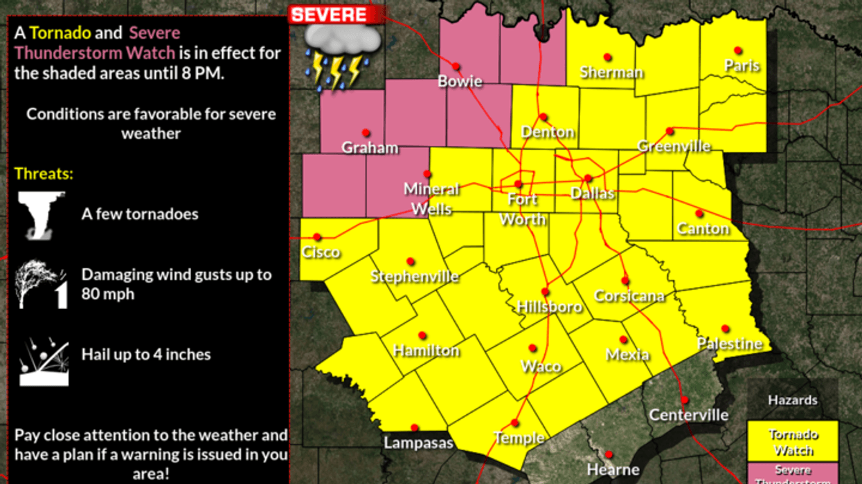
A slow-moving cold front approached North Texas from the north on Wednesday. Combined with plenty of surface moisture and daytime heating, it will produce scattered severe storms throughout the day. More storms will form along the dry line later Wednesday afternoon as it surges in from the west. The threats will be hail 2 inches in diameter or bigger, damaging wind over 60 mph, flooding, and an isolated tornado.
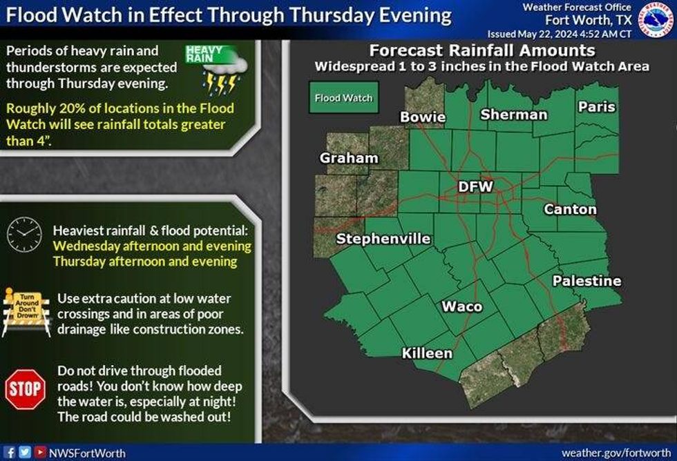
A Flood Watch goes into effect at 10 a.m. Wednesday and lasts through late Thursday night. Afternoon highs will approach 90 degrees before the storms form.
Storms should wind down and head south of DFW in the evening, but there could be a few scattered storms anywhere across North Texas through 12 a.m.
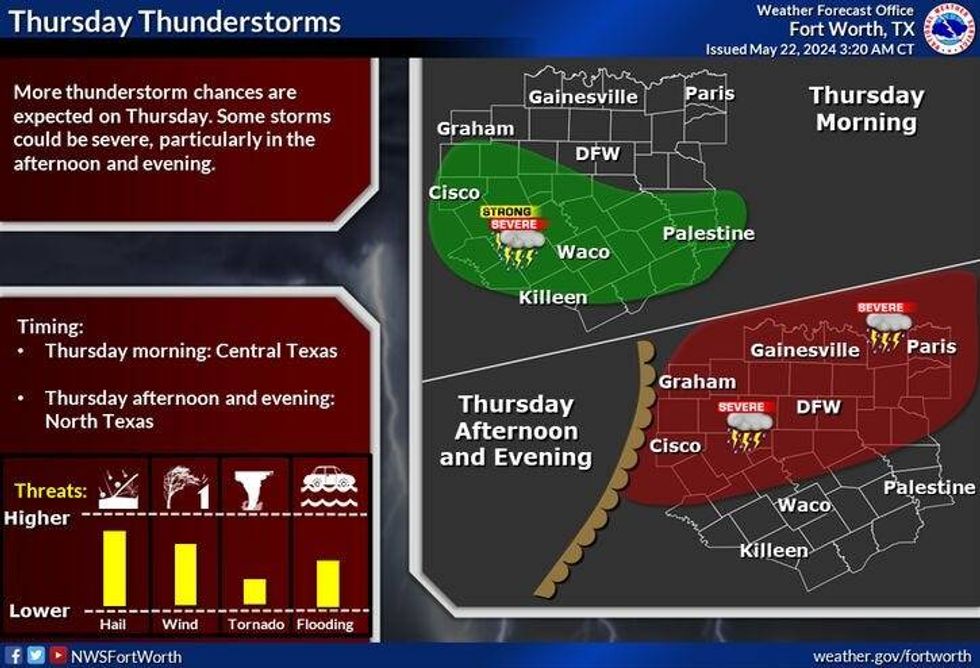
More storms are in the forecast for Thursday afternoon and evening as the cold front lifts back to the north. Large hail and damaging wind will be the main threats, along with the potential for more flooding in areas. Afternoon highs will reach the mid-80s.
 Flood Watch issued for North Texas through Thursday night.National Weather Service
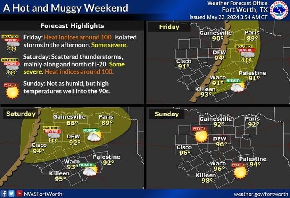
Scattered late afternoon and evening storms remain in the forecast for Friday and Saturday. Most of the storms should stay south of Interstate 20 on Friday, but a few will form anywhere across North Texas on Saturday. Afternoon highs will be in the low 90s on Friday, and in the mid-90s on Saturday.
No rain is in the forecast on Sunday, but it will be very hot, breezy, and humid. Afternoon highs will reach the mid to upper 90s. Heat index values will be over 100 degrees.
It looks like a cold front will move through the area during the first half of Memorial Day. Some areas will only reach the 80s for highs, while others will still be in the 90s south of the front. No rain is expected as of now.
Tuesday will be a seasonable day with low humidity. Plenty of sunshine with afternoon highs in the mid-80s.
 More severe storms are possible on Thursday, May 23, 2024.National Weather Service
7-Day Headlines
* DFW Airport reached 90 on Wednesday.
* Flood Watch from 10 a.m. Wednesday through Thursday night.
* Severe storms Wednesday.
* Another severe threat Thursday.
* All modes of severe weather are possible.
* A hot and humid holiday weekend ahead. A few late-day storms Friday & Saturday.
* Sunday and Memorial Day are hot, humid and dry.
_____________________________________________________
*Tuesday Rain: 0.00"; Tuesday High: 90; Low: 76
*Wednesday's Averages: High: 86; Low: 67
*Record high: 99 (2005) Record low: 51 (1931)
_____________________________________________________
*May Rain: 3.72"; Surplus: 0.44"
*2024 Rain: 20.99"; Surplus: 5.90"
*Sunrise: 6:24am; Sunset: 8:26pm
_____________________________________________________
Wednesday: **Flood Watch starts at 10am** Morning clouds, brief afternoon sunshine. Scattered strong and severe storms through the day. Threats: Large hail > 2", damaging winds and an isolated tornado. High: Upper 80s. Wind: South 10-20 mph.
Wednesday night: **Flood Watch** Scattered storms continue, some severe through midnight. Mild and muggy. Low: Low 70s. Wind: SE 10-15 mph.
Thursday: **Flood Watch** Morning clouds, afternoon sun. Scattered afternoon & evening storms. Some severe. Threats: Large hail, damaging wind and an isolated tornado. High: Mid to upper 80s. Wind: South 10-20, G25 mph.
Friday: Partly cloudy and warm. A few late day storms. Some severe, especially south of I-20. High: Low 90s.
Saturday: Mostly sunny, breezy, hot and humid. A few afternoon and evening storms. High: Low to mid 90s.
Sunday; Mostly sunny, breezy, hot and humid. High: Mid 90s.
Memorial Day: Mostly sunny, breezy, hot, and humid. Cold front. High: Mid 80s.
Tuesday: Sunny and seasonable. Dy aIr! High: Mid 80s
 Weekend rain and temperaturesNational Weather Service
LISTEN on the Audacy App
Tell your Smart Speaker to "PLAY 1080 KRLD"
Sign Up to receive our KRLD Insider Newsletter for more news
Follow us on Facebook | Twitter | Instagram | YouTube


