A couple more warm days ahead, before a strong cold front drops temperatures to below seasonal averages into the weekend into early next week. Unfortunately, no rain is in the forecast for the next 7 days, with the exception of "possibly" some patchy drizzle tomorrow morning.
We're waking up the temperatures in the 60s this morning with some cloud cover overhead. These clouds are associated with a leftover tropical cyclone ('MAX") that has worked its way out of central Mexico and is now forming a surface low off the lower Texas coast. Unfortunately, none of the rain to our SE will make it into our area. Afternoon highs will range anywhere between 78 and 84 from south to north.
Low clouds will invade overnight tonight with morning lows in the low to mid 60s. There may even be some patchy drizzle around as well. Plenty of sunshine will break out by afternoon with highs jumping up between 85° and 90° from east to west. A south wind will gust to 30 mph.
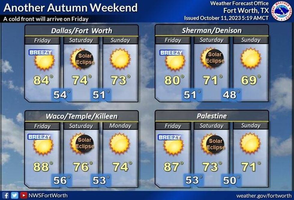
Our next weather change arrives before noon on Friday, as a strong cold front moves into the area. Unfortunately no rain will accompany this front, but a northerly wind will... as cooler/drier air moves in from the northern plains states....just in time for the weekend! Most of us will reachthe low 80s on Friday, but we'll cool off rapidly by the evening hours.
 NWS
NWS
You'll wake up to temperatures in the upper 40s to low 50s on Saturday morning, with a north wind gusting to 25 mph. Sunny, breezy and cool for Saturday with highs in the low to mid 70s.
Temperatures will fall into the mid 40s to low 50s both Sunday and Monday mornings, with afternoon highs in the low 70s. A good eight degrees below average for this time of the year. A slow warm up Is on the way by the middle of next week.
Have a great day and please enjoy the weather when you can, it's the only weather you've got!
7-DAY HEADLINES
* DFW Airport hit 85 degrees yesterday.
* Above average temperatures through tomorrow.
* Below average temperatures arrive Friday, and will last for a while!
* A bunch of wind through Saturday.
* 40s and 50s in the mornings; 70s in the afternoons
* No rain for the next 7 days.
_____________________________________________________
*Yest Rain: 0.00"; Yest High: 85; Low: 62
*Today's Averages: High: 81; Low: 59
*Record high: 99 (1979): Record low: 42 (1905, 1931, 1990)
_________________________________________________________
*October Rain: 1.04"; Deficit:
*2023 Rain: 16.70"; Deficit:
*Sunrise: 7:30am; Sunset: 6:59pm _________________________________________________________
Today: Partly cloudy, breezy and warm. High: Low to mid 80s. Wind: South 10-20, G25 mph.
Tonight: Partly cloudy, breezy and mild. Low: Low to mid 60s. Wind: South 10-20, G25 mph.
Thursday: Morning clouds, with patchy drizzle. Becoming partly cloudy by afternoon. Windy and warm. High: 85-90.
Friday: Late morning DRY cold front. Mostly sunny, windy and cooler. High: Near 80 (early).
Weekend: Saturday's morning annular eclipse (87% coverage in DFW; 10:23am - 1:29pm). Sunny, breezy and cool. Highs: Low 70s; Lows: 45-52.
Monday and Tuesday: MOTS (More of the same). Sunny and pleasant. Lows: 45-52; Highs: Low to mid 70s.
LISTEN on the Audacy App
Tell your Smart Speaker to "PLAY 1080 KRLD"
Sign Up to receive our KRLD Insider Newsletter for more news
Follow us on Facebook | Twitter | Instagram | YouTube