


A Winter Storm Warning is in effect now until 8:00 p.m. Tuesday instead of 6:00 a.m. Wednesday morning. That's some good news.
Anywhere between 1" to 3" of snow fell overnight across north Texas. I still don't have snow totals because it's still dark out and no one wants to venture out.
I'm hoping and praying that all of you have power restored very very soon! It's been a very trying time, not just for us, but for the entire state of Texas and for a big chunk of the United States. This is the coldest air mass any of us have experienced in Texas in over 30 years. To make matters worse, we had between 4"-7"of snow in a past few days. It's been even worse to the south and southeast of the Dallas/Fort Worth area over the past 3 to 4 days. Heavy snow a few days ago and now accumulating freezing rain and sleet are plaguing areas along and southeast of a Tyler to Corsicana to Waco to Gatesville line. These areas had seen heavy freezing rain and sleet overnight and this will continue through the 1st half of today.
Areas of light snow will continue through the morning tapering off to flurries this afternoon and evening. An additional 1/2" of snow is possible in some areas, with a bit higher totals this morning with the bursts of snow.
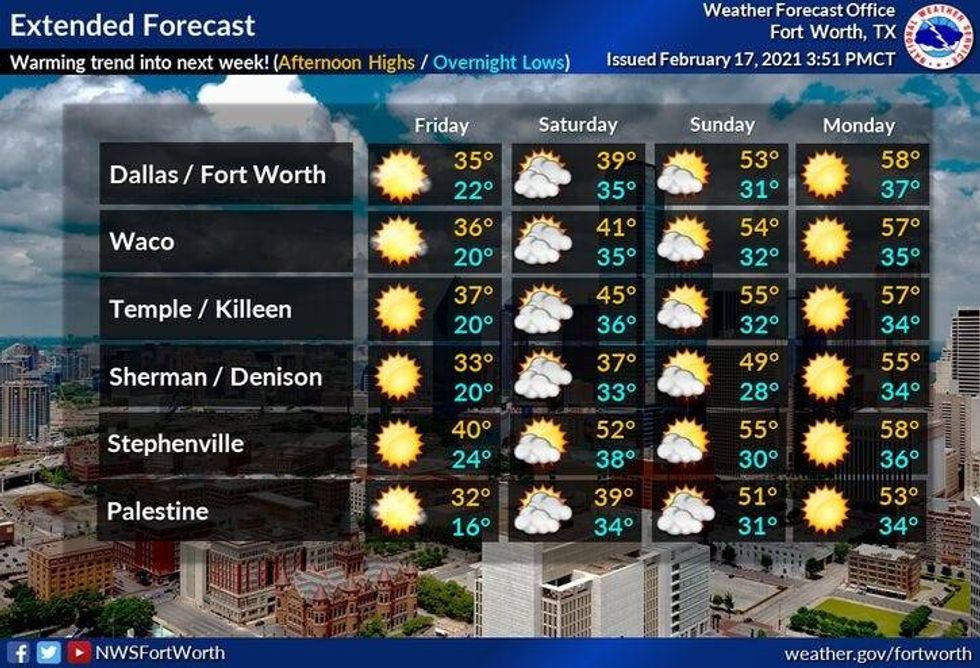
Temperatures will remain cold today and tomorrow with high temperatures in the low twenties today and upper twenties tomorrow. We should get slightly above freezing with sunshine on Friday and then really warming up into the weekend!
A peek at next week, high temperatures in the fifties and sixties with sunshine!
 NWS
NWS
7-Day Headlines:
* Temperatures inching towards the melting point today.
* Slightly above freezing by Friday.
* Morning black ice today through Saturday.
* Warming up this weekend!
* Even warmer NEXT week! 60s to near 70? Mmmmm huh!
__________________________________________________________
*Yest Rain: 0.16"; Snow: 1"; *Yest High: 27; Low: 18
*Today's Averages: High: 61; Low: 40
*Record high : 85; (1986); Low: 10: (1936)
___________________________________________________________
*February rain: 0.38"; February deficit: "
*2021 Rain: 1.23"; 2021 deficit: ">
*Sunrise: 7:08am; Sunset: 6:16pm
___________________________________________________________
Today: Partial clearing as we approach the melting point! Still cold though. High: Near 30. Wind: NNW 15-25 mph.
Tonight: Partly to mostly cloudy and cold. Below freezing still. Low: 18-23. Wind: NNE 10-20 mph.
Friday: Morning clouds, some afternoon sun. Slightly above freezing!!! High: Mid 30s.
Weekend: Warming up and thawing out! Highs: Saturday: 37-43; Sunday: Low 50s!
Monday: Mostly sunny and nice! High: Mid to upper 50s.
Tuesday: Sunny and warmer. 65 degrees warmer than this past Tuesday morning!! High: Low to mid 60s.
Wednesday: Sunny windy and warm! High near 70! REALLY? Yes!!!
 NWS
NWS
 NWS
NWS


