Thursday's North Texas Forecast Discussion:
Severe weather season persists across North Texas, with two or three additional chances of severe storms anticipated in my 7-day forecast. Welcome to late May!
A quiet start this morning is marked by clouds attempting to move in from the south, with temperatures around average, ranging from the mid to upper 60s. Today will be warm and humid, with plenty of sunshine and afternoon highs reaching the low 90s, accompanied by a light south wind. However, this evening will see a change as a slow-moving cold front approaches our area.
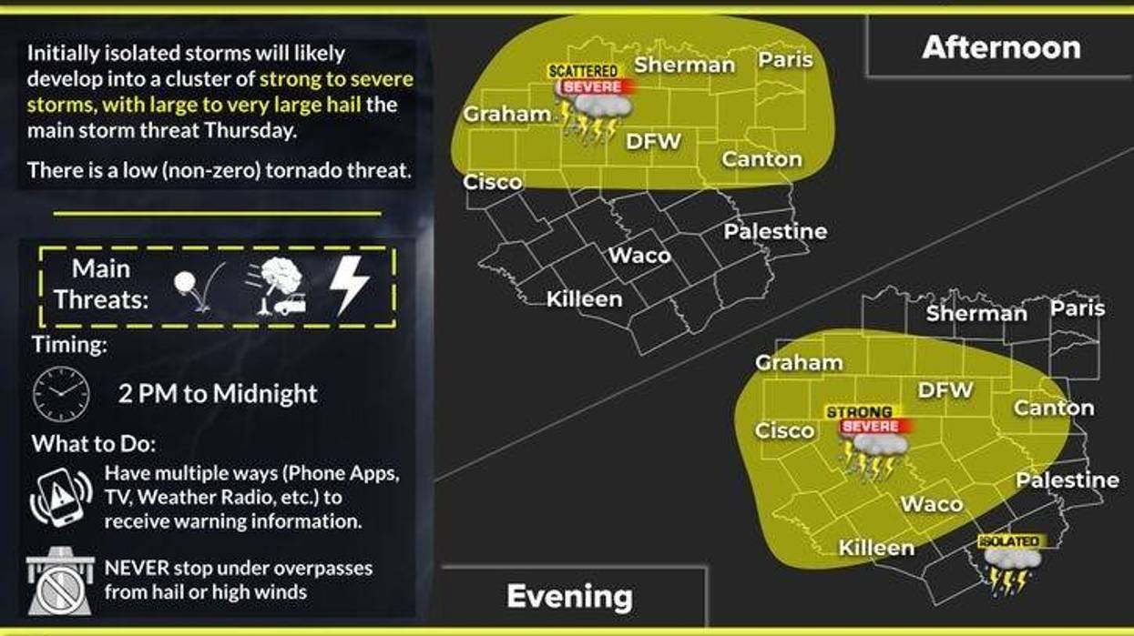
Widespread shower and thunderstorm activity will develop to our northwest and move into the area late this evening through early tomorrow morning. Please remain weather-aware between 8:00 p.m. to the north, 10:00 p.m. and midnight across DFW, and points south thereafter. Hail and damaging winds are the primary threats, with a very low tornado threat. Most areas will receive a half inch to an inch of rain.
Friday through most of Sunday is expected to be uneventful, warm, breezy, and humid, with afternoon highs on Friday reaching the low 90s, mid-90s on Saturday, and near 90 on Sunday.
Our next weather change will arrive Sunday evening, as another cold front heads in our direction. This slow-moving front may bring heavy rain across the area Sunday night through Memorial Day, with some storms potentially becoming severe, featuring hail and wind as primary threats. Two waves of heavy rain are anticipated: one late Sunday night into early Monday morning and another wave Monday afternoon and evening. The heaviest rain will fall along and ahead of the slow-moving cold front, with everything expected to move south of us by Monday evening.
Cooler temperatures behind the front are a welcome prospect, with readings dropping into the 60s amidst steady rain during Monday afternoon. Skies will slowly clear on Tuesday, with highs only in the low 70s, followed by mid-70s with sunshine on Wednesday. Morning lows will be in the 50s area-wide.
Please stay tuned to NewsRadio 1080 KRLD AM throughout the rainy periods. We will activate the KRLD Storm Center team coverage if necessary, with updates at least every 10 minutes.. I will also continue to keep you updated on this page.
Have a great day and enjoy the weather when you can, it's the only weather you've got.
7-Day Headlines:
DFW hit 88 degrees on Wednesday.
Strong to severe storms arrive late this evening. 50% coverage.
Threats: Large hail, damaging wind.
Stay weather aware toward bedtime!
Please download our Audacy App. Favorite KRLD.
Next storm chance late Sunday into Memorial Day.
*Yest Rain: 0.00"; Yest High: 88 Low: 61
*Today's Averages: High: 86; Low: 67
*Record high: 99 (2005): Record low: 51 (1931)
*May Rain: 2.31"; Deficit:
*2025 Rain: 16.24"; Surplus: 1.15"
*Sunrise: 6:24am; Sunset: 8:26pm
Thursday: Some morning clouds, afternoon sun. Warm. High: Near 90. Wind: South 5-10 mph.
Thursday night: Scattered storms, some severe between 8pm to 1am. Threats: Large hail and damaging wind. Low: 65-70. Wind: South 5-10.
Friday: Partly cloudy, warm and humid. High: Low 90s.
Saturday: Partly cloudy, hot and humid. High: Mid 90s.
Sunday: Increasing clouds, warm and humid. Widespread storms by late evening, through the overnight into Monday. High: Low 90s.
Monday: Showers and storms continue. Heavy rain threat. Slow moving cold front. High: Low 70s.
Tuesday: Mostly cloudy and pleasant. High: Low 70s.
Wednesday: Partly cloudy and nice! High: Mid 70s
LISTEN on the Audacy App
Tell your Smart Speaker to "PLAY 1080 KRLD"
Sign Up to receive our KRLD Insider Newsletter for more news
Follow us on Facebook | Twitter | Instagram | YouTube