
Well weather-wise, not a lot is changing around here. It’s going to be pretty decent today, Friday, and as we head into the upcoming weekend. The biggest story right now will be the warming trend.
We’ve been rather cool for this time of year this past week, but now temperatures are starting to climb as a little bubble of high pressure builds across the area this weekend.
Highs will push well into the 80s today, and I believe we’ll see low 90s Friday and Saturday, likely continuing into Sunday and Monday as well.
There will still be a few showers and storms around — some this afternoon into the evening hours — but nothing like what we’ve seen over the past several days. Same idea late Friday, with a slightly better chance late Saturday into early Sunday morning as storms kind of meander around North Texas.
If you’ve seen a lot of rain recently, flooding could still occur pretty quickly with any heavier downpours.
Next week, we’ll keep an eye on a front that may back into the area Tuesday and Wednesday. If that happens, shower and thunderstorm chances could increase a bit and temperatures may drop back into the 80s for highs.
Also, hurricane season officially starts Monday. That doesn’t mean we’re going to see a hurricane on Monday, but typically in June and July the Gulf of Mexico becomes the climatological area where tropical systems can form.
By August and especially September, storms tend to develop farther east off the western coast of Africa and track across the Atlantic, the Caribbean, and sometimes into the Gulf of Mexico. Again, this doesn’t mean we can’t get a strong hurricane this season — it’s something we’ll watch closely over the coming months.
Have a great day today and enjoy the weather when you can — it’s the only weather you got!
_____________________________________
7-Day Headlines:
- DFW Airport hit 85 degrees on Monday. Officially: 0.02” of rain
- Keep you umbrella handy though next week
- Isolated showers and storms through next Monday
- Scattered showers and storms Tuesday and Wednesday
- Threats: Heavy rain, lightning, gusty wind, small hail
- 90+ degree temps on the way, heat index near 100 degrees
- Download our AUDACY app. Listen to KRLD at home
Almanac:
- Yest Rain: 0.02”; Yest High: 85; Low: 67
- Today’s Averages: High: 87; Low: 68
- Record high: 107 (1927); Record low 51 (1907)
- May rain: 2.96”; Deficit: <01.22”>
- 2026 Rain: 13.18”; Snow: 2.4” Deficit: <2.81”>
- Sunrise: 6:22am; Sunset: 8:30pm
Forecast:
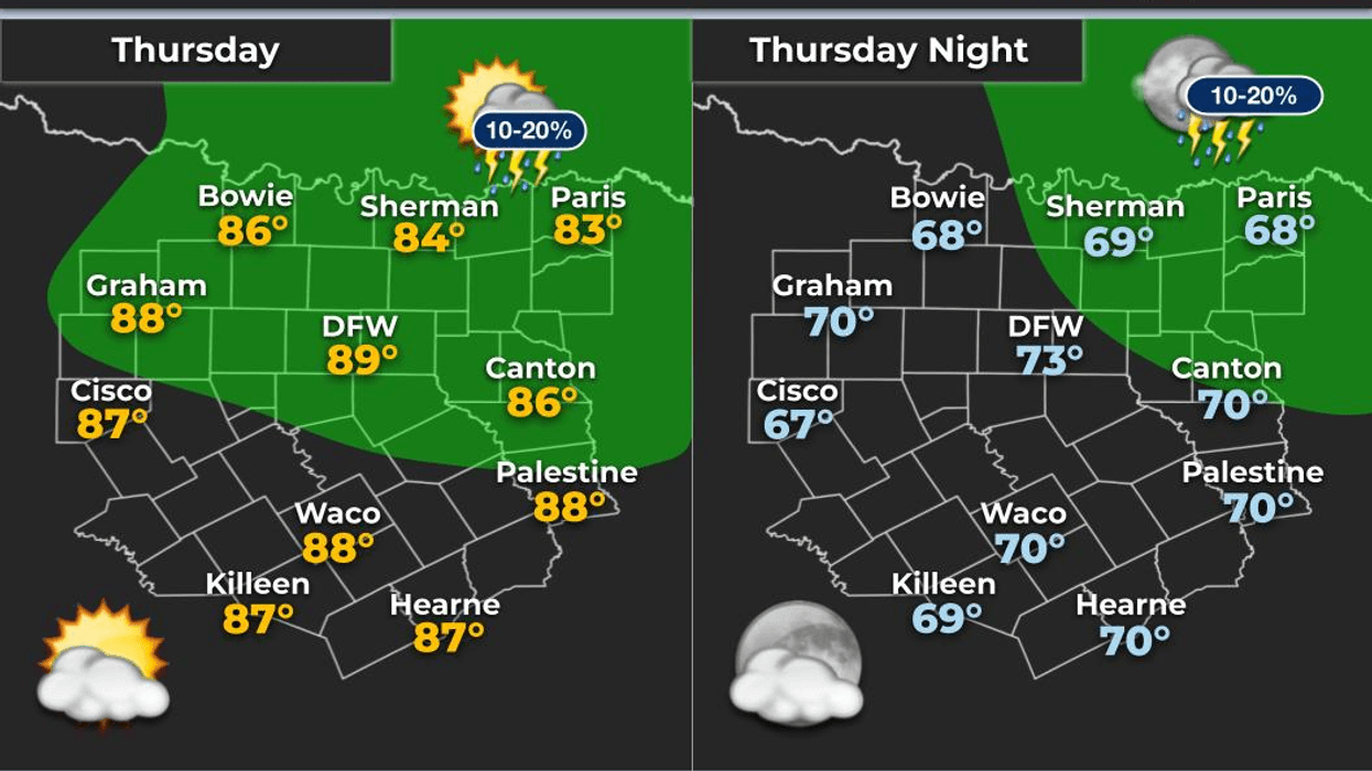
Thursday: *Air Quality Alert* Partly cloudy, warm and humid. Isolated late day showers and storms. High: Upper 80s. Wind: WSW 5 mph.
Thursday night: Partly cloudy and humid. Low: Near 70. Wind: SE 5 mph.
Friday: Partly cloudy, warm and humid. Isolated late day storms.. High: Low 90s. Heat index near 100 degrees. Wind: South 5-10 mph.
Weekend: Partly cloudy, warm and humid. Isolated showers and storms. Highs: Low 90s. Heat index near 100 degrees.
Monday - Wednesday: Partly cloudy, warm and humid. Scattered afternoon and evening storms. Highs: 87-92.
LISTEN on the Audacy App
Tell your Smart Speaker to "PLAY 1080 KRLD"
Sign Up to receive our KRLD Insider Newsletter for more news
Follow us on Facebook | Twitter | Instagram | YouTube