We're starting off this morning chilly for this time of the year, as readings have fallen into the 40s under a clear sky. Today will be a beautiful day with plenty of sunshine. Afternoon highs will top out in the low 70s. Below average for this time of the year. The average high is 77°.
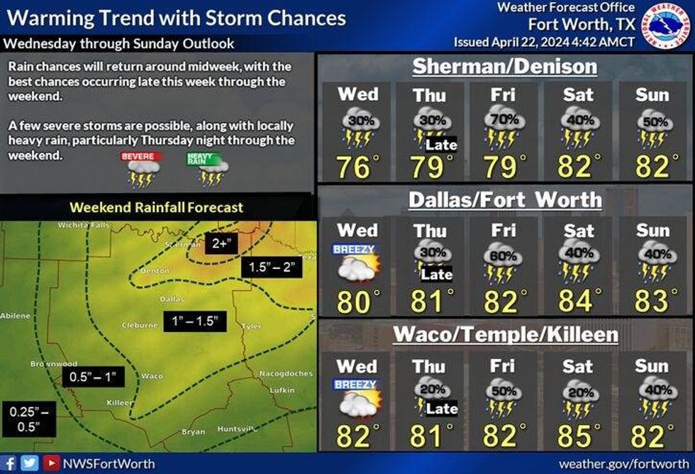
We'll start off tomorrow in the low to mid-50s as south winds pick up. It'll be a breezy day with highs approaching 80°. There will also be a weak front that'll stall along the Red River late in the day. This may produce a few strong thunderstorms both tomorrow and Wednesday late in the day. A few may become severe, but they will not affect the Dallas/Fort Worth area. Afternoon highs on Wednesday will be near 80°.
 National Weather Service - Fort Worth
The dryline will start to get active to our west Thursday through the weekend. A few of these storms may sneak into the area late Thursday evening. Some may become severe.
Scattered storm chances, some severe. will continue mainly in the late evening hours Friday through Sunday. I'll definitely keep an eye on things and update you as we get closer. Afternoon highs through the period will be in the low 80s.
*Yest Rain: 0.00"; Yest High: 65; Low: 51
*Today's Averages: High: 77; Low: 57
*Record high: 94 (1963); Record low: 39 (1927)
*April Rain: 3.81"; Surplus: 1.69"
*2024 Rain: 14.61"; Surplus: 3.90"
*Sunrise: 6:50am; Sunset: 8:04p
LISTEN on the Audacy App
Tell your Smart Speaker to "PLAY 1080 KRLD"
Sign Up to receive our KRLD Insider Newsletter for more news
Follow us on Facebook | Twitter | Instagram | YouTube