"Oh what a night"..... NOT late December back in '63, but early March in '26. A significant flooding event occurred just south and east of Dallas last night, with totals ranging from 4 to 7 inches. DFW Airport broke a record for daily rainfall, receiving 1.55 inches. I welcome you to almost Friday.
The extreme rains last night caused damage and power outages in some areas, and I offer my sincerest apologies to those affected. Fortunately, the rain has ceased for the time being.
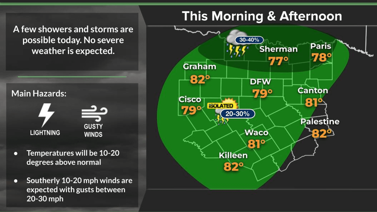
We are waking up to a cloudy sky with temperatures in the mid-60s, 20 degrees above average for this time of year. Although unlikely for most of you today, keep your umbrella handy; isolated showers and thunder are possible this afternoon. High temperatures will reach the upper 70s, the average high for this date is 65 degrees.
The next weather system will arrive Friday afternoon and evening, bringing isolated strong to severe thunderstorms across North Texas. Although the coverage will not be as widespread as Wednesday evening, there is a possibility of large hail, damaging winds, and isolated tornadoes. Approximately 50% of the area will remain dry on Friday, with afternoon highs nearing 80 degrees.
A strong cold front will arrive early Saturday, bringing temperatures down from the upper 60s in the morning to the low 50s by dinner time. Additionally, waves of rain, some heavy at times, will move over North Texas throughout the day. The rain shield is expected to shift south of DFW as the day progresses, with flooding being a major concern, especially for areas that experienced heavy rain on Wednesday night. Severe weather is not anticipated.
The position of the cold front Sunday and the trajectory of the upper-level disturbance will determine if we see more heavy rain across parts of North Texas. Afternoon highs will be cool with readings in the low 60s, slightly below average for this time of year. The cold front will move back north Sunday night into Monday, bringing a chance for showers and isolated storms, however, severe weather is not expected. Highs on Monday will return to the 70s.
A stronger storm system will approach the area on Tuesday, bringing a decent chance for showers and storms in the late afternoon and evening hours. Some of these storms may become severe, and this is something that will be closely monitored. Highs on Tuesday will be well into the 70s, providing ample fuel for the storms. Rain chances may persist on Wednesday, depending on the speed and track of the strong upper-level low approaching on Tuesday. Please stay tuned for updates. Temperatures may be slightly cooler by the middle of next week, with highs in the 60s.
Please exercise caution on the roads and keep your hands on the wheel. Have a nice day!
7-Day Headlines:
* DFW Airport reached 81 yesterday.
* 1"-8" of rain fell yesterday. 1.55" at DFW broke a daily record.
* Severe weather threat returns late Friday.
* Threats: Hail, wind, and isolated tornadoes.
* Flooding threat returns this weekend. Severity is low.
* Stay weather aware!
* More storms, some severe next Tuesday.
*Yest Rain: 0.00"; Yest High: 81; Low: 64
*Today's Averages: High: 65; Low: 45
*Record high: 96 (1991); Record low 20 (1989)
*March rain: 1.55"; Surplus: 1.13"
*2026 Rain: 3.79"; Snow: 2.4" Deficit:
*Sunrise: 6:50am; Sunset: 6:29pm
Thursday: Morning clouds, some afternoon sun. Windy and mild. Scattered showers and isolated storms. NOTHING like Thursday's rain. High: Upper 70s. Wind: South 15-25, G30 mph.
Thursday night: A few showers late. Low: Mid 60s. Wind: South 15-25 mph.
Friday: Morning clouds, some afternoon sun. Scattered showers and storms, some severe. Threats: Large hail, damaging wind, an isolated tornado. High: Mid to upper 70s. Wind: South 10-20, G30 mph.
Saturday: Morning cold front. Showers and storms are a good bet. Flooding a concern. Severe storms south and east are possible. Waves of heavy rain. Highs: Upper 60s early into the 50s by dinnertime.
Sunday: Mostly cloudy and cooler. More rain on the way. High: Low 60s.
Monday: Cold front lifts north. Mostly cloudy, breezy and warmer. Scattered showers and storms. High: Low to mid 70s.
Tuesday: Mostly to partly cloudy, breezy and mild. Scattered showers and storms. Some possible severe? High: Mid to upper 70s.
Wednesday: Mostly to partly cloudy and cooler. A few leftover showers. High: Mid 70s.
LISTEN on the Audacy App
Tell your Smart Speaker to "PLAY 1080 KRLD"
Sign Up to receive our KRLD Insider Newsletter for more news
Follow us on Facebook | Twitter | Instagram | YouTube