


Above-average temperatures through Thursday, turning cooler Friday through the weekend, and unfortunately, no rain is in the forecast for the next 7 days.
It's a cool start this morning with temperatures mainly in the 50s across north Texas. Plenty of sunshine today with afternoon highs warming into the mid to upper 80s. Wind will be light from the south.
Increasing clouds tonight and cool with morning lows in the upper 50s to the mid-60s.
Tomorrow will be mostly cloudy, breezy, and a little bit cooler with afternoon highs in the low to mid-80s. It will feel the same on Wednesday as well. Thursday will be the warmest day this week with afternoon highs pushing 90°.
 National Weather Service - Fort Worth
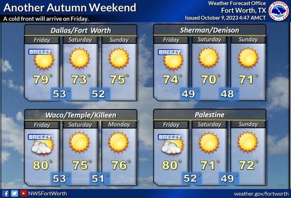
Our next weather change arrives Friday morning as a dry cold front moves through the area. It will turn windy and cooler with afternoon highs in the middle 70s, North winds will gust to 30 mph.
Cool mornings and mild afternoons will be our weather story as we approach the weekend with morning lows in the 50s and afternoon highs in the low 70s.
*Yest Rain: 0.00"; Yest High: 79; Low: 52
*Today's Averages: High: 81; Low: 60
*Record high: 96 (2017): Record low: 36 (1917)
*October Rain: 1.04"; Surplus: 0.17"
*2023 Rain: 16.70"; Deficit: 11.44"
*Sunrise: 7:28am; Sunset: 7:03pm
Monday: Mostly sunny and warm. High: Mid to upper 80s. Wind: South 5-10 mph.
Tonight: Partly cloudy and cool. Low: 58-64. Wind: South 10 mph.
Tuesday: Mostly cloudy, breezy and warm. High: Low to mid 80s. Wind: SSW 10-20 mph.
Wednesday: Mostly to partly cloudy, windy and warm. High: Low to mid 80s.
Thursday: Partly cloudy, windy and warmer. High: Near 90.
Friday: Morning DRY cold front. Mostly sunny, windy and cooler. High: Mid 70s.
Weekend: Sunny, breezy and cool. Highs: Low 70s; Lows: 50s.
LISTEN on the Audacy App
Tell your Smart Speaker to "PLAY 1080 KRLD"
Sign Up to receive our KRLD Insider Newsletter for more news
Follow us on Facebook | Twitter | Instagram | YouTube


