Yesterday was indeed a beautiful day. Unfortunately, temperatures are expected to rise today and tomorrow, but another cold front will bring cooler temperatures and rain for some into the holiday weekend.
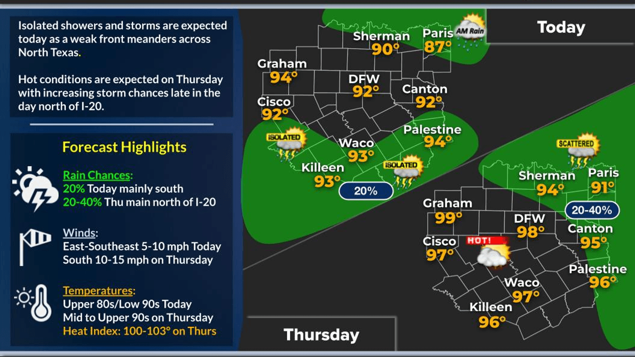
Good morning and happy Wednesday, ladies and gentlemen. This morning, we are experiencing some cloud cover and there are showers to the north and east of the Dallas-Fort Worth area, but they are moving eastward away from North Texas. While I cannot rule out an isolated shower today, afternoon highs are expected to reach the low 90s, which is slightly below average for this time of year.
The front that has been to our south will move back to the north today, allowing temperatures to heat up for Thursday. Partly cloudy conditions will prevail, with afternoon highs reaching the upper 90s. Although I do not think we will hit 100 degrees, we will come close.
Our next weather change will arrive on Friday as another rare August cold front moves into the area. Scattered showers and thunderstorms will move into the Dallas-Fort Worth area on Friday. According to current data, most of the rain will be just east and north of our area. However, I hope this forecast is incorrect. Temperatures will be cooler on Friday, warming up only to the 80s.
This front will stay to our south for the holiday weekend, as a couple of upper-level disturbances ride along the front, producing widespread shower and thunderstorm activity mainly west of the Dallas-Fort Worth area late Friday into Saturday. While I am not entirely convinced that some of this rain will move into DFW, it is a possibility. Afternoon highs will reach the low to mid-80s. Heck yeah!
Another disturbance will ride along the front, which will be well to our south, late Saturday into Sunday. As of now, it appears that the heavy rain will stay just to the west and the SW of the Dallas-Fort Worth area. However, I cannot rule out some scattered showers and storms, especially just west of Interstate 35W.
A slow warm-up is expected Monday and Tuesday of next week. However, some extended data, which is subject to change, indicate another cold front arriving by the middle of next week. This would keep our temperatures below average and bring rain chances back to the area. Please stay tuned for updates on this forecast.
Have a great day today, and please enjoy the weather when you can, it's the only weather you've got!
7-Day Headlines:
DFW hit 88 degrees on Tuesday.
An isolated shower today. Warmer!
A hot Thursday to come.
Friday cold front.
Scattered showers and storms.
Scattered showers and storms continue Saturday and Sunday.Heaviest rain west of DFW.
Cooler temperatures.
Labor Day looks dry.
*Yest Rain: 0.00"; Yest High: 88 Low: 74
*Today's Averages: High: 94; Low: 75
*Record high: 107 (1901); Record low: 61 (1906)
*August Rain: 1.45"; Deficit:
*2025 Rain: 23.61"; Surplus:
*Sunrise: 7:00am; Sunset: 7:58pm
Wednesday: Partly cloudy and warmer. An Isolated late-day shower. High: Low 90s. Wind: SSE 5-10 mph.
Wednesday night: Partly cloudy and pleasant. Low: Mid to upper 70s. Wind: SE 10-15 mph.
Thursday: Partly cloudy and hot. High: Mid to upper 90s.Wind: SSW 10-20 mph.
Friday: Scattered showers and storms. Heaviest west of DFW. Cooler! High: 80N-95S.
Weekend: Partly to mostly cloudy and pleasant. Scattered showers and storms. Heaviest west of DFW. Some afternoon sun. High: Mid 80s.
Labor Day: Partly cloudy and warmer. High: Near 90.
Tuesday. Mostly sunny and seasonable. High: Low 90s.
LISTEN on the Audacy App
Tell your Smart Speaker to "PLAY 1080 KRLD"
Sign Up to receive our KRLD Insider Newsletter for more news
Follow us on Facebook | Twitter | Instagram | YouTube